
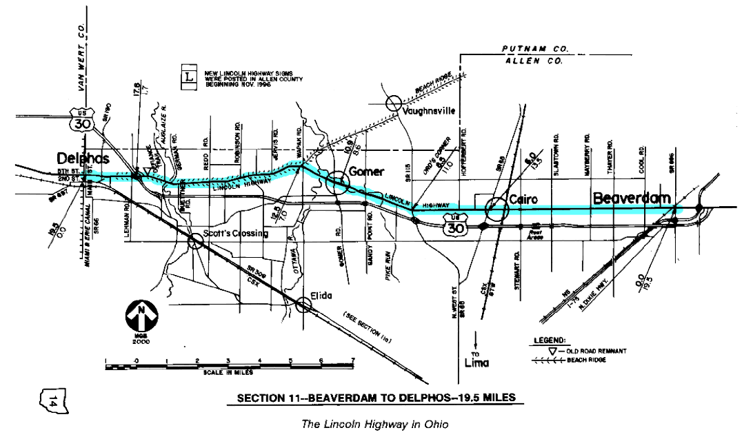
SECTION 11—BEAVERDAM TO DELPHOS—19.5 MILES
The route of the 1928 Lincoln Highway between Beaverdam and Delphos is virtually the same alignment of roadway that bears that name through Allen County today. The historic route across the "top" of Allen County has legally been known as Lincoln Highway since November 27, 1968, although the history of the highway in this particular location began almost fifty years prior.
As discussed in Section 10, Lincoln Highway officers finally adopted a route through Williamstown and Beaverdam as part of the coast-to-coast route in 1919—just in time for the coming of the U.S. Army's Transcontinental Motor Convoy in July. This "northern" route had been a corridor of travel since 1835, when the Bucyrus and Fort Wayne State Road was laid out. Except for a diversion around a beaver swamp at the future site of the town of Beaverdam, this alignment through Allen County is nearly a duplicate of what the first surveyors had laid out. In 1844, another survey of the road was made from Williamstown to and through the new canal town of Delphos, that road being called the Williamstown Free Turnpike Road.
The town of Beaverdam was laid out where the Bucyrus Road crossed the Lima and Findlay State Road. Originally the two roads crossed at a 45-degree angle; therefore, when surveyors laid out the town in the typical rectangular pattern of streets and lots, the "diagonal" course of the Findlay Road was altered to square up with the east-west Bucyrus Road. Thus, on the east side of town, Church Street became part of the Findlay Road, and as the town grew westerly toward the railroad, West Street became part of that road as well. Because the Bucyrus Road and Findlay Road would eventually become the Lincoln Highway and Dixie Highway, respectively, Beaverdam could boast of having two great transcontinental routes that overlapped for several blocks within her borders—a fortunate circumstance which would prove beneficial to the town through four decades.
Indeed, Beaverdam is one of many towns in the United States which have laid claim to being "The Crossroads of America." Where the highways once overlapped on Main Street, many tourist services were offered, including the Dixie-Lincoln Restaurant. At one time, AT&T had a major switching station which transferred calls from all corners of the nation, somewhat like the two highways. Today, the large truck stops at the I-75 interchange give testimony to the fact that the town still has a legitimate claim to that title.
This section of the coast-to-coast route has also had an interesting history relative to numerology. On Ohio's "First Official Map of the State Highway System," dated 1912, only that portion of the route at the beach ridge was numbered. It was designated as Inter-County Highway #133, or Findlay-Delphos Road. A designation for that part of the route bearing easterly from the beach ridge did not occur until about 1922, when the maps begin to indicate Inter-County Highway #512, or Delphos-Upper Sandusky Road. Since that time, this section has been numbered State Route 5 (1923), then U.S. Route 30-N (1931), and then U.S. Route 30 (1973), although most of this section of roadway lost its "30" designation in the early 1970s, when a new four-lane highway section of U.S. 30 from Beaverdam to Delphos was opened. The city of Delphos was bypassed as part of another project near the end of that decade.
The notion of "Main Street Across America" is perpetuated quite well in this section of the Lincoln Highway. Within the corporate limits of both Beaverdam and Cairo (the post office was known as West Cairo until 1922), the legal name of the roadway is Main Street. In the unincorporated community of Gomer, the main street retains the Lincoln Highway name. Although railroads at one time passed through each of these three towns, it is fair to say that all these towns grew up on the Bucyrus Road/Lincoln Highway, because each has developed in an east-west direction (the direction of the highway) instead of in a north-south direction (the direction of the railroads).
The community of Gomer was the site of the most noteworthy event in the local history of the Lincoln Highway. On the afternoon of Saturday, October 29, 1939, Admiral Richard Byrd's "Snow Cruiser," traveling from Chicago to Boston, "scraped the corner of a bridge just east of Gomer [0.5 mile east of the schoolhouse], went out of control and landed in muddy Pike Run, tearing down a farm fence and guardrail en route." The vehicle was "a 37 ton giant...55 feet long, 20 feet wide and 16 feet high...designed by Dr. Thomas Poulter and built in Chicago for [Byrd's] Antarctic expedition." Poulter and nine others passengers were involved in the crash (Byrd was not a member of the traveling party) which brought national media attention to the community of Gomer, plus "an estimated 125,000 spectators" during that weekend. The crash of the Snow Cruiser was blamed on "a break...in the hydraulic line that controlled the steering  and brakes. The cause of the break was never determined."
In 1939, the Snow Cruiser built for Admiral Byrd's Antarctic explorations ran off the road east of Gomer and crashed. The event brought in the national media attention and an estimated 125,000 spectators. LHA member Ray Gottfried, who built this scale model, may be the world's leading authority on the subject.
Keeping with the idea of bridges, several structures remain in this section which were built in the 1920s. One worth noting is the bridge over the Ottawa River at 0.75 miles west of Gomer, which is an attractive old triple-arch concrete structure, similar to several others along the route which have been or will be replaced. Another more unique structure is the small bridge with the slightly arched parapet walls, which is 1.4 miles east of Gomer, at another crossing of Pike Run. The bridge at the site of the "Snow Cruiser" crash was similar to this, but was replaced in 1955 as part of a U.S. 30 improvement project. The present curve here is not as sharp as the curve which existed at the time of that crash.
Although this route has been in nearly the same general location since 1835/1844/1919, there have been a number of significant reconstruction projects. These projects include the typical bridge replacements or refurbishing, plus the smoothing and superelevating of curves. One example of a curve improvement project is at the highway's intersection with what is now State Route 115, once known as Ord's Corner. When the Lincoln Highway passed through Lima, this truly was a corner in the sense that the transcontinental route made nearly a right angle turn at this point. As a result of this project, a sharp 7-degree curve was replaced with a smooth 2-degree curve, thus improving what has always been a dangerous intersection, but requiring the elimination of a gas station at the northwest corner.
There is apparently only one place in this entire section where new construction was far enough away from the original pavement so as not to disturb it. At a point one-half mile west of the Auglaize River bridge—a refurbished triple-arch structure—there is a short remnant of old roadway on the north side of the road, at a barnyard now on private property. This remnant can be adequately observed without leaving the public right-of-way, and for that reason, tourists should stay at or along the roadway.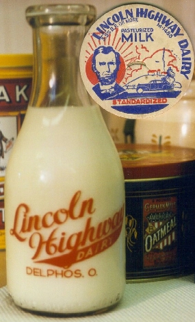
In the city of Delphos, the route of the 1928 Lincoln Highway is at Fifth Street, all the way through town. However, until the mid-1920s—or perhaps when U.S. 30 was first marked—the route entered the town by way of Second Street. This street had been the main east-west street of Delphos going back to the days of the Bucyrus and Fort Wayne State Road. At present-day Main Street, the route turned north for three blocks, where it intersected Fifth Street, then matching the 1928 route toward Van Wert.
Today, the original route at Second Street can no longer be followed completely, because the street now dead-ends just short of Fifth Street on the east side of town. During the mid-1950s, a new junction point for U.S. 30-N and U.S. 30-S was constructed—now the intersection of Fifth Street and Elida Road—which moved the original junction point out of downtown Delphos. At that time, or perhaps a little later, it appears that the legal access from Second Street to Fifth Street was closed, thus creating the dead-end at the east end of Second Street. The original route can still be explored by making some creative diversions in the east part of Delphos.
While in Delphos, the tourist may also want to explore a part of the old Miami and Erie Canal. The canal follows the county line north and south through town, one-half block westerly from and parallel with Main Street. A very informative historical marker on the north side of Fifth Street, at the crossing of the canal, provides a good background for the history of this once-important waterway. The Delphos Canal Commission has a museum in the old bank building at the southwest corner of Main Street and Third Street which is now home to the Lincoln Highway sign from the destroyed brick pillar at Oceola.
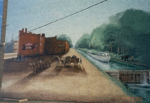 Delphos also has a mural celebrating its canal heritage (see Massillon). Remnants of the old locks and aqueducts of the Miami and Erie Canal can still be observed in and around town. On April 21, 2001, Delphos will be the host site for the Seventh Annual Meeting of the Ohio Lincoln Highway League.
On the opposite side of Fifth Street from the canal marker is the third concrete post replica to be placed along the route in Ohio. This post was dedicated on September 1, 1997, sixty-nine years to the day after the original posts were set. Appropriately, the Boy Scouts were on hand that foggy day for the unveiling of the new post.