|
|
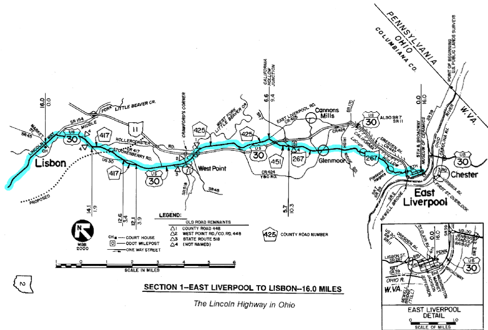
SECTION 1—EAST LIVERPOOL TO LISBON—16.0 MILES
The beginning of the charted course for the grand tour of the
Lincoln Highway across Ohio is in downtown East Liverpool, at the
intersection of Fifth Street and Broadway. At the southeast corner of
this intersection is the city's old post office, which is now the
Museum of Ceramics, operated by the Ohio Historical Society. Also on
this corner is one of the concrete Lincoln Highway posts that were set
along the 1928 version of the route—the featured route in this road
guide. Although not in its original position, this now-reinforced post
is in good condition, and an appropriate point to begin this 241-mile
tour.
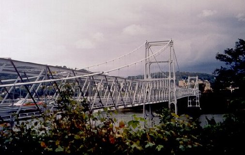
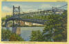 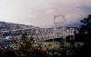 The Chester Bridge (left) was built in 1897, and
carried the Lincoln Highway from 1928 to 1969. Prior to the opening of
the Jennings-Randolph Bridge in 1977, U.S. 30 was temporarily routed
over the Newell Bridge (below). The Chester Bridge (left) was built in 1897, and
carried the Lincoln Highway from 1928 to 1969. Prior to the opening of
the Jennings-Randolph Bridge in 1977, U.S. 30 was temporarily routed
over the Newell Bridge (below).
In 1928, the route of the Lincoln Highway crossed the Ohio River into
East Liverpool by way of the Chester Bridge. This bridge was built in
1897, and at one time carried the local trolley, crossing the river
from the north end of First Street in Chester to the south end of
College Street in East Liverpool. It was dismantled after its closing
in spring 1969. Between that time and the opening of the
Jennings-Randolph Bridge in November 1977, U.S. Route 30 was
temporarily routed over the Newell Bridge, which still exists about a
mile downstream. Because the new bridge is part of a limited access
highway, the "zero" point for the odometer charts has been established
at the more accessible downtown location.
Between East Liverpool and Lisbon, the 1928 route of the Lincoln
Highway was very much influenced by the same Appalachian topography
that prevailed in Pennsylvania and West Virginia. Having to rise from
the banks of the Ohio River before winding its way through the hills
and hollows of Columbiana County, this section—from an engineering
standpoint—may have been the most challenging of all the Lincoln
Highway sections built in Ohio. Until 1928, the Lincoln Highway in
Columbiana County had been "one of the worst stretches in the east."
However, according to the 1924 Guide, more than 27miles of
improvements, at the cost of over one million dollars, had resulted in
"one of the finest stretches of hard surfaced Lincoln Highway between
the two coasts."
Even into the 1970s, challenging projects were being undertaken to
bring U.S. 30 into Ohio and through East Liverpool. The
Jennings-Randolph Bridge, and the interchange at the north end of that
bridge, are perhaps the most impressive engineering projects on any
part of U.S. 30 in Ohio. In the 1980s, more new construction was
completed through the Third Street corridor of East Liverpool, but
apparently with some delays—the right-of-way plans carry dates from
the early 1970s. These projects were the last links of a four-lane
superhighway (U.S. 30 in part; S.R. 11 in full) from the Ohio River to
Lake Erie.
From the north end of the old Chester Bridge, the 1928 route followed
Third Street, Jefferson Street, and Eighth Street, to Lisbon Street,
which predictably, was the road of that day to Lisbon. Lisbon
Street—then and now, also designated State Route 267—is noteworthy in
that it features the most dramatic climb of any that is made on Ohio's
portion of the Lincoln Highway. Bearing northwesterly from the area of
the Eighth Street intersection (elevation about 760 feet), a climb of
over 350 feet is made, in just 0.9miles, to the Pleasant Heights
neighborhood (elevation about 1120 feet). This ascent includes a long
steep grade of 10 percent.
A significant three-mile section of brick was also in this part of the
route, extending from Eighth Street to the old Y&O Railroad crossing
at Glenmoor. The oldest part of this brick may have been one of the
first brick pavings in the entire state. Perhaps it still remains
beneath the existing blacktop.
Within East Liverpool, there may have been at least two different
Lincoln Highway alignments between 1913 and 1928. Maps in both the
1921 and 1924 Guides show the route passing through downtown on
Pennsylvania Avenue and Fifth Street, meeting the 1928 route at
Jefferson Street. Other evidence suggests that at one time, Sixth
Street may also have been a part of the route—photographs from June
1915 picture buildings on that street which are all decked out in red,
white, and blue, for the "official opening" of the Lincoln Highway.
This 1915 event was also the occasion of a motion picture crew
arriving in town, whose purpose was to take pictures along the Lincoln
Highway for a premiere showing at the Panama-Pacific Exposition in San
Francisco. It is believed that eight towns in Ohio made monetary
contributions for the movie project in order to be included in the
film. East Liverpool, at that time the pottery center of the nation,
celebrated the opening of the highway in a most unique way—by blowing
up the old glass house kiln, which had been covered with pottery
donated by local manufacturers.
A mystery which remains at East Liverpool is why the Lincoln Highway
route was not relocated to follow the route of U.S. 30 when the latter
was first marked in 1927. The route of U.S. 30 took a more northerly
direction out of downtown, avoiding the steep climb that existed on
Lisbon Street. It followed Market Street and Dresden Avenue into the
area known as California Hollow, and continued to and through the
community of Cannons Mills, and then met the Lincoln Highway route at
what is now the intersection of East Liverpool Road (County Road 425)
and Old Lincoln Highway (County Road 451), a point which came to be
known as California Hollow Junction. The route of the Lincoln Highway
was marked as State Route 267, which despite some small modifications,
still exists today. The route for the new U.S. 30 was used until the
late 1960s, when the present four-lane expressway, also known as State
Route 11, was opened in multiple phases.
As a result, the route of U.S. 30 was not the route marked in
September 1928 with the new concrete posts. Perhaps when Gael Hoag was
planning the locations of all the markers, he was not sure where the
proposed U.S. 30 was going to be routed. Or perhaps the pavement of
the new route was not yet in a satisfactory condition, which is
implied by the maps of that time. Oddly, the 1926 Ohio Department of
Highways map shows a tentative location through East Palestine, not
East Liverpool. Whatever the case may be, the portion of the Lincoln
Highway which became State Route 267 is the only part of the 1928
route in Ohio which was not part of either U.S. Route 30 or State
Route 5.
Out in the countryside of Columbiana County, beyond the junction of
State Route 267, the early routes of the Lincoln Highway/U.S. 30 in
this section continue to be characterized by change. The first routes
of the Lincoln Highway had generally followed the route of
Inter-County Highway #12, or Cleveland- East Liverpool Road. This was
one of the major routes laid out in 1912 on Ohio's first map of
numbered highways [see Appendix D], and had been a corridor of travel
for nearly 100 years, connecting the town on the river with the city
on the lake. However, there was apparently at least one variation of
the Lincoln Highway from that first version of the inter-county
highway, because what is now Rollercoaster Road (not shown as part of
I.C.H.#12) was once part of the transcontinental route. This road is
appropriately named, with its alternating "up and down" grades. Later,
what is now the path of Stookesberry Road (which was part of I.C.H.#12)
was chosen for the Lincoln Highway route, and it was this route that
later inherited the federal designation of U.S. 30. This was a more
level route which ran parallel with Patterson Creek, bearing
northwesterly from the community of West Point.
The three miles of Stookesberry Road in Elkrun Township apparently
included one of Ohio's two Seedling Miles—the Lincoln Highway
Association's object lesson in concrete. In July 1918, Columbiana
County applied to the association for 2000 barrels of cement to
improve one mile of a 3.1-mile highway project near Lisbon. The Board
of County Commissioners was gracious in expressing their thanks and
appreciation to the association, pledging to "use its best efforts to
complete the Lincoln Highway in Columbiana County at the earliest
possible date." Ohio's other Seedling Mile was more than 200 miles
away, in Paulding County, on the opposite side of the state—very close
tothe Indiana line.
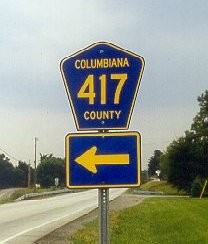
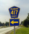 Between East Liverpool and Lisbon, tourists should
watch for blue-on-yellow signs for County Roads 451, 425, and 417, all
of which were parts of the Lincoln Highway. Between East Liverpool and Lisbon, tourists should
watch for blue-on-yellow signs for County Roads 451, 425, and 417, all
of which were parts of the Lincoln Highway.
In the odometer charts for this section, the scenic Stookesberry Road
remnants have been made a part of the charted course, resulting in a
temporary departure from U.S. Route 30. To anticipate these
diversions, travelers should watch for the standard five-sided
yellow-on-blue county road number signs at the various intersections,
and not the typical road name signs. In the case of Stookesberry Road,
watch for the blue sign with [county road number] 417 in yellow.
Directions to Rollercoaster Road, which is nearby, are included in the
odometer charts for those tourists who desire to cover every possible
alignment of the transcontinental route.
Other short Lincoln Highway remnants that are still open to traffic
are parts of State Route 518 and West Point Road, both between U.S.
Route 30 and the community of West Point. However, because of both the
difficult turning movements from and to U.S. 30, and the relative
shortness of these two remnants, neither has been made a part of the
charted course. Another remnant, which is northeast of West Point and
now labeled County Road 448, is no longer open to through traffic
because the bridge over the West Fork of Little Beaver Creek has been
removed. Photographs of this concrete arch bridge appear in both the
1921 and 1924 editions of the Lincoln Highway Guide. The bridge
replaced an old steel span known as Brown's Bridge.
These segments, like those at Stookesberry Road, plus two unmarked
remnants closer to Lisbon, all became remnants when U.S. Route 30
underwent major reconstruction and realignment, starting in the 1940s.
Thus, it can truthfully be said that most of U.S. 30 between State
Route 11 (near West Point) and Lisbon is an entirely different road
from the one traveled in 1928. Several old remnants are now on private
property.
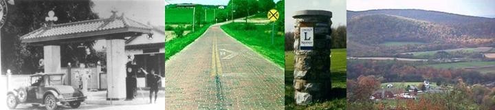
Lisbon is one of three Ohio towns where the Lincoln Way street name is
still being used. Interestingly, in both Lisbon and Minerva, the name
of the roadway had been Walnut Street before the coming of the Lincoln
Highway. In Massillon, that city's Lincoln Way was originally Main
Street through the downtown, and Wooster Road out the west side of
town.
Odometer charts for this section
Strip Maps for this section
|
