|
|
1928
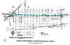
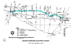
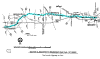
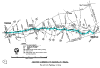
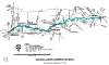
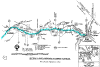
ROUTE EASTBOUND ODOMETER CHART
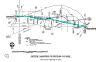
HOW TO USE THESE CHARTS
Numbers indicate the mileage eastbound from the control station, or
zero point, at the west end of the subject section. All mileages are
scaled from the quadrangle maps of the United States Geological
Survey. The tourist must allow for small mileage corrections within
each section because of the inherent accumulating errors of the
typical car odometer.
 The zero milepost at the Ohio/Indiana state line is
also the "zero" point for the eastbound tour of the Lincoln Highway
across Ohio. The Ohio Department of Transportation places similar
milepost signs along every state and federal highway in Ohio, with
mileages being measured from either west-to-east, or from
south-to-north, based on the roadway distance from the county line. If
a route begins within a particular county (not entering the county at
a county line), the zero milepost is placed at the beginning point of
that route. For those tourists who will be faithfully using these
odometer charts, the twenty mileposts of U.S. Route 30 in Hancock
County (mileposts 0 thru 19) provide an excellent
opportunity for you to calibrate the odometer of your vehicle. The zero milepost at the Ohio/Indiana state line is
also the "zero" point for the eastbound tour of the Lincoln Highway
across Ohio. The Ohio Department of Transportation places similar
milepost signs along every state and federal highway in Ohio, with
mileages being measured from either west-to-east, or from
south-to-north, based on the roadway distance from the county line. If
a route begins within a particular county (not entering the county at
a county line), the zero milepost is placed at the beginning point of
that route. For those tourists who will be faithfully using these
odometer charts, the twenty mileposts of U.S. Route 30 in Hancock
County (mileposts 0 thru 19) provide an excellent
opportunity for you to calibrate the odometer of your vehicle.
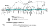
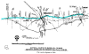
1928 ROUTE
SECTION 13--INDIANA STATE LINE TO VAN
WERT
SECTION 12--VAN WERT TO DELPHOS
SECTION 11--DELPHOS TO BEAVERDAM
SECTION 10--BEAVERDAM TO UPPER SANDUSKY
SECTION 9--UPPER SANDUSKY TO BUCYRUS
SECTION 8--BUCYRUS TO CRESTLINE
SECTION 7--CRESTLINE TO MANSFIELD
SECTION 6--MANSFIELD TO WOOSTER
SECTION 5--WOOSTER TO MASSILLON
SECTION 4--MASSILLON TO CANTON
SECTION 3--CANTON TO MINERVA
SECTION 2--MINERVA TO LISBON
SECTION 1--LISBON TO EAST LIVERPOOL
SECTION 13 -- INDIANA STATE
LINE TO VAN WERT 15.4 MILES
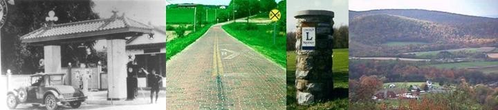
0.0—CONTROL STATION AT Ohio/Indiana State Line; the
construction of four-lane U.S. 30 through the southwest corner of
Paulding County obliterated one of the Lincoln Highway Association's
two Seedling Miles in Ohio
1.2—Paulding/Van Wert County Line; note another milepost 0 at Right
2.0—Bridge over Blue Creek; old road remnants are at Left in
makeshift barnyard
5.9—Turn Left onto Dixon-Cavett Road at 0.7 miles easterly from
milepost 4
6.0—Junction with Lincoln Highway; to observe the bridge over Upper
Prairie Creek, which has Lincoln Highway signs in the ends of the
parapet walls, turn sharply Left for 0.1 mile; return to this
point and...
0.0—Reset odometer to zero; then proceed easterly with Lincoln
Highway
 0.8—Replica Burma-Shave signs at Right 0.8—Replica Burma-Shave signs at Right
5.7—Original roadway angled sharply here, passing at the immediate
north edge of the cemetery; remains of a small culvert are sometimes
visible in the grassy area at the southeast corner of the intersection
7.0—After stop sign at U.S. Route 224, continue easterly with
Lincoln Highway
7.5—Ridgeway Drive-In Theater at Left was formerly Lincoln Drive-In
7.7—Former Restwell Motel at Right
8.2—Old Carl G. Wright complex at Right; post cards list "modern
cabins, restaurant, garage, service station, and barber shop"
8.4—Economy Inn, formerly Stripe's Westside Motel at Left
8.6—B&K Root Beer stand at Left; original neon sign
8.7—Spray's Radiator Service is at northeast corner; has nice display
of petroliana signs; began as a Shell station in 1927
9.2—Brumback Library at Left was the first county library in the
United States (1901); at Right, opposite the library is a restored
concrete post
9.4—ORIGINAL CONTROL STATION at Right is at the Marsh Hotel in
VAN WERT, as called for in the early Lincoln Highway Guides; Van Wert
County Court House is at Left; also at Left is "Balyeat's Coffee
Shop—Nationally Famous Since 1924"; reset odometer to zero
SECTION 12--VAN WERT DELPHOS
13.4 MILES
0.0—Continue easterly with Main Street
0.6—Turn Left onto Wayne Street; note old gas station at
northwest corner
0.7—At yellow flashing signal, turn Right onto Lincoln Highway
3.2—Interchange with four-lane U.S. Route 30; near the southwest
corner of the interchange is a single brick post, which marked the
boundary corner for a roadside rest area that was removed when the
four-lane highway was built; similar brick posts can be found at other
older roadside rests in Ohio
3.8—Ohio Bicentennial Barn at Left
4.5—Church at Left; the east-west driveway immediately in front of the
church is an old road remnant
5.0—Line of utility poles diverging at Left side of road delineates
both the original and present right-of- way line (a good way to
imagine where the road used to be, before reconstruction in the early
1940s); the first of several such areas in this section; the many
trees planted within the right-of-way area are a result of the highway
beautification plan for that reconstruction project
5.6—Lincolnway (Van Wert County Home) at Right; the east-west driveway
immediately in front of the building is an old road remnant; note
replica Burma-Shave signs along both sides of the highway
5.8—Ringwald Road T's Right; south of this point is an old
road remnant, now a farmhouse driveway
6.5—Pole line diverging at Left, as per 5.0 above
7.4—Old road remnant at Right, in front of old Dutch Mill buildings
7.9—Van-Del Drive-In Theater is at Right
8.5—Pole line diverging at Left, as per 5.0 above
9.7—Road diverges from crest of beach ridge of Maumee Glacial Lake,
which bears southeasterly
11.4—Pole line diverging at Left, as per 5.0 above; note surviving
trees from beautification plan
12.0—Location of Mox Curve was at Right, now on private property; the
only trace of the old roadbed is a grass strip between the house and
the creek
 12.6—Old Lincoln Inn at Left 12.6—Old Lincoln Inn at Left
12.7—Lincoln Highway Dairy was at Left, at small metal-sided building;
dairy operated under this name from 1915 to about 1956
12.9—After stop sign and red flashing signal, continue easterly
with Fifth Street; also junction with State Route 66
13.4—CONTROL STATION at DELPHOS is at the traffic signal at the
intersection of Main Street; Miami and Erie Canal parallels Main
Street at one-half block to the west; there is a historical marker at
the west bank of the canal at the north side of the street; former
Lincoln Highway Garage is at northeast corner; concrete post
replica is near southwest corner; reset odometer to zero
SECTION
11--DELPHOS TO BEAVERDAM 19.5 MILES
0.0—Continue easterly with Fifth Street
0.5—Arrow Motel at Left
0.7—Second Street Y'd Back Right; now closed here, this was part of a
previous route from downtown Delphos (compare 1924 Guide)
0.8—Old junction point of U.S. 30-N and U.S. 30-S from 1950s to 1970s
1.7—Interchange with four-lane U.S. Route 30; continue easterly
with Lincoln Highway
2.2—Old road remnant on private property, at barnyard area at
Left
 3.1—Buettner Road T's Right 3.1—Buettner Road T's Right
3.9—Lincoln View Farm at Right
5.4—Abandoned roadside rest at Right
6.4—"Grave" shown on 1949 right-of-way plans is at Left, surrounded on
four sides by guardrails; supposedly the grave of Shadrack Benham, to
whom the government deeded this quarter-section of land in 1835
7.8—New bridge opened in 2002 replaced triple-arch concrete bridge;
historical marker to be placed at Right, before river
7.0—Leave the beach ridge of the Maumee Glacial Lake, which bears
northeasterly toward Findlay; except for the area through Delphos and
immediately west of Delphos, the route followed the beach ridge all
the way from New Haven, Indiana, a distance of over 48 miles
8.6—Sugar Creek Township School at GOMER at Left
9.1—1955 bridge over Pike Run; this bridge is about 50 feet north of
the previous bridge, which was the site of the crash of Admiral Byrd's
"Snow Cruiser" in 1939
10.0—1927 bridge over Pike Run, with unique arching parapet walls
11.0—ORD'S CORNER; after stop sign at State Route 115, continue
easterly with Lincoln Highway
13.5—At traffic signal, State Route 65 X's N-S at CAIRO ;
Lincoln Log Cabin is at northeast corner
17.5—Former site of hubcap sculpture pictured in Drake Hokanson book
(after page 48) was at the northeast corner of this intersection
19.5—CONTROL STATION at BEAVERDAM is at the red flashing signal
at the intersection of West Street; fire station is at the southwest
corner; the brick building just south of the fire station was once a
relay station for all coast-to-coast telegrams; reset odometer to zero
SECTION
10--BEAVERDAM TO UPPER SANDUSKY 36.8 MILES
0.0—Continue easterly with State Route 696/Main Street; for 0.3
miles from this point, Dixie Highway/U.S. 25 overlapped the Lincoln
Highway/U.S. 30
0.3—Brick pillar replica erected in 1999 by OLHL is at Right; Church
Street, which T's Left, was part of Dixie Highway/U.S. 25
1.1—Interchange with four-lane U.S. Route 30; S.R. 696 ends;
continue easterly with Lincoln Highway
8.0—At traffic signal, continue easterly with Lincoln Highway/U.S.
Route 30; State Route 235 X's here and interchanges with new U.S.
30 at one-half mile south
10.4—Old roadside rest area at Right; two brick corner posts are at
rear of parcel
 11.0—Gentle reverse curve at milepost 6; clue of
township line in rectangular survey system 11.0—Gentle reverse curve at milepost 6; clue of
township line in rectangular survey system
12.5—NEW STARK
16.0—"Truckers Welcome/Bon-Air Motel" at Left
16.6—Begin bypass of WILLIAMSTOWN; note old road remnants
at Right; old railroad overpass was location of a photograph in Drake
Hokanson book (after page 48)
21.3—Old brick schoolhouse at Right; supposed location of old tourist
cabin pictured in Hokanson book (after page 48) is on opposite side of
road
23.0—Gentle reverse curve at milepost 18; compare to 11.0 above
31.5—Old road remnant Y's Ahead Right; now a private drive
31.6—Bridge over Oak Run is a replacement of previous structure which
was about 200 feet Right
31.7 to 32.2—Township Road 54, a half-mile old road remnant
which parallels U.S. 30, is at Right
32.3—Bridge over Tymochtee Creek is third in Lincoln Highway history
at this location; first location was at Left; second location was at
Right
32.4—Township Road 102 T's Left; old road remnant and access to
observe remnants of old bridge
 33.5—Turn Right onto County Road 330, leaving
U.S. 30 33.5—Turn Right onto County Road 330, leaving
U.S. 30
33.6—Township Road 330 T's Right; this old road remnant was
rendered by construction of the bypass, and is now a dead-end access
road to a farmhouse
36.0—At yield sign, turn Right onto Warpole Street
36.35—Turn Left onto Wyandot Avenue
36.8—CONTROL STATION at UPPER SANDUSKY is at the traffic signal
at the intersection of Sandusky Avenue; Wyandot County Court House is
at southeast corner; reset odometer to zero
SECTION 9--UPPER SANDUSKY
TO BUCYRUS 16.7 MILES
0.0—Continue easterly with Wyandot Avenue, also with State Route
182
0.2—Brick pillar replica at Right, at southeast corner of
Fourth Street
 0.55—New bridge over Sandusky River, replaced George
Washington Bridge in 1998; old road remnants are ahead at Right 0.55—New bridge over Sandusky River, replaced George
Washington Bridge in 1998; old road remnants are ahead at Right
0.65—Avoid State Route 182, which turns Right (south); continue
easterly with Wyandot Avenue
0.7—Old brick road remnant at Right, marked Old Lincoln
Highway; Ohio Bicentennial Commission/Ohio Historical Society
marker was erected here in October 2001
1.7—Lincoln Highway Farm at Left
2.1—Junction with two-lane U.S. Route 30, and interchange with
four-lane U.S. Route 23; continue easterly with U.S. Route 30
3.5—Lincoln Hills Golf Club at Right is the former site of Lincoln
Hills Tourist Court
5.5—Relocated concrete post, along driveway to farm at Right
7.5—Old roadside rest area at Right; the brick corner posts at both
front and rear of property are typical for old rest area parcels in
Ohio, and should not be confused with Lincoln Highway pillars
10.0—Marion-Melrose Road X's at OCEOLA ; a brick pillar replica
is at the northeast corner of this intersection, near location of a
similar pillar destroyed in 1993
10.1—The Oceola Garage at Right, is the replacement of Sipe's
Filling Station, which was destroyed by fire shortly after Drake
Hokanson made one of my favorite photographs in his book (after page
48)
11.0—Original brick pillar at Right , at top of sideslope, about 200
feet past U.S. 30 milepost 2
12.7—Avoid ramp for eastbound U.S. 30, which bypasses Bucyrus;
continue with Lincoln Highway
16.6—Old Texaco gas station at northwest corner of Poplar Street
16.7—CONTROL STATION at BUCYRUS is at the traffic signal in
Washington Square at the intersection of Sandusky Avenue; a relocated
concrete post is ahead in green space at Left; reset odometer
to zero
SECTION
8--BUCYRUS TO CRESTLINE 13.3 MILES
0.0—Continue easterly with Mansfield Avenue
0.1—Crawford County Court House at Left (See West Bound charts
for old postcard of this section)
0.4—Lincoln Highway sign in abutment wall of railroad viaduct
0.95—Stone pillar at Left, at golf course; stones are probably
left over from...
1.1—Hopley Monument, also at Left, also at golf course
2.2—Junction with two-lane U.S. 30; continue easterly with U.S.
Route 30/Lincoln Highway
2.7—Original brick pillar at Right, at northwest corner of
Stewart Cemetery
 8.1—At Right, the large white building with skylights
was part of the Green Lawn Auto Court 8.1—At Right, the large white building with skylights
was part of the Green Lawn Auto Court
The large building at the front of the old Green Lawn Auto Court
was remodeled long ago, but survives between Crestline and Bucyrus.
8.6—Angle Right onto Leesville Road, taking temporary leave
from U.S. 30
10.3—LEESVILLE; J&M Trading Post is ahead at Right; stop and
say hello to Joe Everly, LHA member
 10.7—Colonel Crawford Monument at Right 10.7—Colonel Crawford Monument at Right
11.7—At stop sign, angle Right onto U.S. Route 30/Lincoln Highway
12.75—Clink Boulevard T's Right (south); original brick
pillars are at both corners
13.3—CONTROL STATION at CRESTLINE is at the traffic signal at
the intersection of Seltzer Street; reset odometer to zero
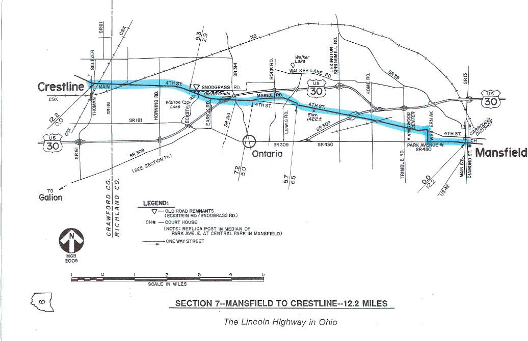
SECTION
7--CRESTLINE TO MANSFIELD 12.2 MILES
0.0—Continue easterly with Main Street/U.S. Route 30
2.9 to 3.3—Snodgrass Road and Eckstein Road at Left are
old road remnants; explorations here are best made when
traveling westbound
 4.2—Avoid ramp for eastbound U.S. 30, which bypasses
Mansfield; continue easterly with Fourth St. 4.2—Avoid ramp for eastbound U.S. 30, which bypasses
Mansfield; continue easterly with Fourth St.
5.0—Angle Left onto Mabee Road, taking temporary leave from
Fourth Street
6.5—At stop sign, turn Left, resuming easterly with Fourth Street
7.1—Highest elevation on Lincoln Highway in Ohio, near
automotive plant; elevation=1422 feet
 10.6—At traffic signal, turn Right onto Western Avenue
11.0—At traffic signal, turn Left onto Park Avenue West
12.2—CONTROL STATION at MANSFIELD is at the
traffic signal at the west side of Central Park, at the intersection
of Main Street; although not directly related to the Lincoln Highway,
a memorial to Abraham Lincoln is near the bandshell at the northeast
corner of Park Avenue and Main Street; the heart of Mansfield's
Carrousel District is two blocks north of this point; reset odometer
to zero
SECTION
6--MANSFIELD TO WOOSTER 32.0 MILES
0.0—Continue easterly with Park Avenue West, also with State Route
430
0.05—In median of Park Avenue East is a concrete post replica
set
0.1—Richland County Court House at Right
0.5—After passing under the railroad bridge, turn Right at traffic
signal , continuing easterly with Park Avenue East/State Route 430
2.4—Old-fashioned Stewart's Root Beer stand at Right
8.0—S.R. 430 ends; turn Right onto State Route 603, which
becomes Maine Street in Mifflin
8.25—Concrete post at/near original position, at Right, just
before main intersection in town
8.3—MIFFLIN; avoid S.R. 603, which turns Right; continue
easterly with Maine Street/Co. Rd. 30-A
13.8—HAYESVILLE; old opera house is near southeast corner;
continue easterly, now with S.R. 179
14.5—Angle Left, resuming with roadway designated County Road 30-A;
diverge from S.R. 179
16.0—Angle Left, continuing with County Road 30-A; avoid road
which continues toward school
16.3—At stop sign, cross four-lane U.S. Route 30 and continue with
County Road 30-A
18.2—State Route 89 X’s at JEROMESVILLE; concrete post replica
is at Right, beyond traffic signal
21.0—Old roadside rest area at Right
22.0—Old Kohler Tavern is at Right is at county line; is on National
Register of Historic Places
 23.2—REEDSBURG 23.2—REEDSBURG
27.6—JEFFERSON; old-fashioned motel is at Left before
intersection
28.3—At stop sign and red flashers, cross four-lane U.S. Route 250 and
continue easterly with Old Lincoln Way/County Road 30-A
31.6—At traffic signal, angle Right onto Liberty Street, also with
State Route 302
32.0—CONTROL STATION at WOOSTER is at the traffic signal in the
city square at the intersection of Market Street; Wayne County Court
House is at northwest corner; reset odometer to zero
SECTION 5--WOOSTER TO MASSILLON
22.1 MILES
(Numerous old motel sites remain in this section; watch also for
several businesses which use Lincoln in their name)
0.0—Continue easterly with Liberty Street
0.4—Angle Left onto Pittsburgh Avenue after crossing railroad
0.7—Lincoln Way Elementary School at Right
1.1—Turn Right onto Bauer Road to reach old road remnant
now known as Sylvan Road, the east end of which is a
ten-foot wide brick remnant with eight-inch wide cement borders;
return to this point and...
0.0—Reset odometer to zero; then resume easterly with Pittsburgh
Avenue
1.4—Junction with two-lane U.S. Route 30, which is also designated
Lincoln Way; continue easterly
 2.3—HONEYTOWN 2.3—HONEYTOWN
5.6—EAST UNION
7.0 to 7.7—Old Lincoln Way at Left is an old road remnant
that is best explored when traveling westbound
8.2—RICELAND; a relocated concrete post is in the rock garden at the
northeast corner
8.7—Turn Right onto Sugar Creek Township Road 129/Kohler Road, then
immediately Left onto Old Lincoln Way
9.1—Concrete post at/near original position at Right, in the
community of McQUAID
9.2—Turn Left onto Kidron Road to return to U.S. Route 30; the
private lane ahead to Camp Luz is another old road remnant
9.3—Turn Right, resuming easterly with U.S. Route 30
9.7—Old road remnant dead-ends near railroad at Left
10.9—Turn Left onto Old Lincoln Way, taking temporary leave
from U.S. 30. Old Lincoln Way becomes Main Street in
Dalton
11.1—Relocated concrete post at Right, on private property
12.0—At traffic signal in DALTON, Mill Street X's N-S; relocated
concrete post is near the northwest corner of the intersection; gazebo
is opposite at Right
13.1—At stop sign, cross the westbound lanes and turn Left onto
four-lane U.S. 30
 13.2—Jones Motel at Left is the site of the old Parkette Motel
The Jones Motel just east of Dalton is the site of the old Parkette
Motel.
14.0—Exit Right, continuing easterly onto State Route 172
15.4—EAST GREENVILLE (old control point in Lincoln Highway
Guides)
18.6—WEST BROOKFIELD (old control point in Lincoln Highway
Guides)
20.6—At traffic signal, angle Left onto Lincoln Way, continuing
with State Route 172
20.8—Cross Four Chaplains Memorial Viaduct
21.1—CONTROL STATION at MASSILLON is at the traffic signal at
the intersection of Erie Street; reset odometer to zero
SECTION 4--MASSILLON TO CANTON
7.9 MILES
0.0—Continue easterly with State Route 172/Lincoln Way
0.05—Relocated concrete post at Right; Massillon Museum is
nearby
0.1—Lincoln Theater at Left
0.8—Lincoln Way Motors at Left
3.1—PERRY HEIGHTS
3.5—Motel Lincoln at Left (See West bound chart for old
postcard of this section)
3.8—Lincoln Way (Massillon) becomes Tuscarawas Street (Canton)
 4.1—REEDURBAN 4.1—REEDURBAN
6.5—Lincoln Hardware ghost sign, on west face of brick building at
Right
7.2—Avoid angle Right where State Route 172 diverges; continue
easterly with Tuscarawas Street
7.5—George's Diner at Right
7.9—CONTROL STATION at CANTON is at the traffic signal at the
intersection of Market Avenue; Stark County Court House is at
northwest corner; a concrete post replica is in front of the
court house; Classic Car Museum is six blocks south of here; reset
odometer to zero
SECTION 3--CANTON
TO MINERVA 16.1 MILES
0.0—Continue easterly with Tuscarawas Street
0.9—Junction with State Route 172; continue easterly with State
Route 172/Tuscarawas Street
3.0—Junction with U.S. Route 30 at Trump Avenue; again continue
easterly, now also with U.S. 30
3.4—Moon Mist Motel at Left
3.5—Site of White Swan Motel at Right, with Cabins
4.75—Concrete post at/near original position at Right
4.8—At traffic signal in EAST CANTON, turn Right, continuing with
U.S. Route 30
5.0—At traffic signal, turn Left, continuing with U.S. Route 30
5.5—Old road remnant now marked Osnaburg Street bears
Back Right with utility poles
5.9—Turn Left onto Cindell Street; this turn is opposite where
S.R. 44 diverges Right
7.2—At stop sign at U.S. 30, turn Left onto Lincoln Street/U.S
Route 30; historic Clearview Golf Course is behind at Right of
U.S. 30
7.4—Old road remnant passes behind Park 'N' Ride lot at Left
7.5—Old road remnant, also marked as Cindell Street, Y's Ahead
Right at Woodland Park Estates
7.5 to 8.1—Old road was located at Right, with line of utility poles
8.3—Turn Left, then immediately Right onto a brick portion of
Cindell Street
8.9—At stop sign, turn Right onto Sam Krabill Avenue, toward
another stop sign; then turn Left, resuming with Lincoln
Street/U.S. Route 30
8.9 to 9.2—Old road was located at Left
10.3—At ROBERTSVILLE, turn Right on Applehill Avenue
 10.4—Angle Left onto Baywood Street, which has long
sections of brick 10.4—Angle Left onto Baywood Street, which has long
sections of brick
12.7—At stop sign, continue easterly with Baywood Street
12.8—At stop sign, turn Right onto Paris Avenue
13.1—At stop sign at U.S. 30, angle Left, resuming with Lincoln
Street/U.S. Route 30
13.3—Brick bridge over Hugle Run; abutment of pre-1935 bridge is 150
feet northeast of here
13.5—Culvert at Left indicates pre-1935 alignment of road
15.0 to 15.2—Cindell Street and Tunnel Hill Road at Left
are old road remnants
15.9—At traffic signal, turn Left onto Lincoln Way, continuing with
U.S. Route 30
16.1—CONTROL STATION at MINERVA is at the traffic signal at the
intersection of Market Street; an old gas station is at southwest
corner; a relocated concrete post is near the southeast corner;
reset odometer to zero
SECTION 2 -- MINERVA TO LISBON
20.0 MILES
0.0—Continue easterly with Lincoln Way and U.S. Route 30, also with
State Route 183
0.4—Lincoln Way Furniture at Right
1.0—State Route 183 diverges Left; note site of Green Gables Tourist
Cabins also at Left
1.1—Star Motel at Right; several years ago, the neon sign still looked
good
2.1—BAYARD
 4.1—EAST ROCHESTER 4.1—EAST ROCHESTER
6.0—LYNCHBURG
9.0—Stop at red flashing signal in KENSINGTON, then turn
Left, continuing with U.S. Route 30
10.4—Angle Right onto Lincoln Street in Hanoverton, taking temporary
leave from U.S. 30
10.55—At stop sign, turn Left (north) onto First Street/County Road
406, crossing bridge
10.6—At traffic signal in HANOVERTON, turn Right, resuming easterly
with U.S. Route 30; a brick pillar replica is at the northeast
corner of this intersection
10.7—Historic Plymouth Street T's Left; Spread Eagle Tavern is up the
street; a concrete post replica is at the northwest corner of this
intersection
11.7—Canal Tunnels historical marker at Right
12.0—Old Stone culvert at Left of S-curve remains from original
alignment
14.8—Trinity Church Road Y's Back Right; old road remnants are
on private property in this area
19.4—Cross high bridge; a stone pier of the old Canton Bridge is below
this bridge
20.0—CONTROL STATION at LISBON is at the traffic signal in town
square at the intersection of Market Street; Columbiana County Court
House is at the southwest corner; Crosser Diner is a half- block back,
at Left; reset odometer to zero
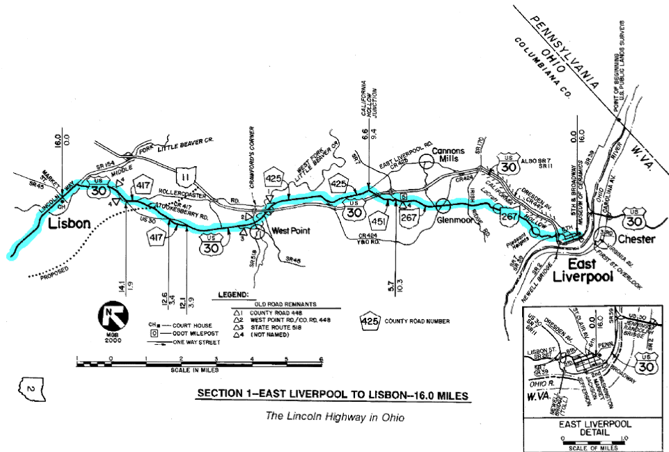
SECTION 1--LISBON
TO EAST LIVERPOOL 16.0 MILES
0.0—Continue easterly with Lincoln Way/U.S. Route 30
0.1—Steel Trolley Diner at Right
0.5—At traffic signal, turn Right, continuing with U.S. Route 30
1.1—Frola Motel and Capehart Motel, both at Right
1.4—Unmarked old road remnant Y's Ahead Left
1.6 to 1.9—Unmarked old road remnant at Right
1.9—Turn Left onto County Road 417, a.k.a. Stookesberry Road,
diverging from U.S. 30
2.3—West end of Rollercoaster Road Y's Ahead Left
3.4—Stop at U.S. 30, then continue with County Road 417
3.9—At stop sign, turn Right, resuming with U.S. 30
4.3—Former Victoria Motel and Trail’s end Motel, both at Left
5.9—Road X's; Road Right is to WEST POINT; Road Left is to CRAWFORD'S
CORNER and Rollercoaster Road; old road remnants abound in this
area (see map); after exploring, return to this point and...
 0.0—Reset odometer to zero 0.0—Reset odometer to zero
0.4—Avoid the ramp for eastbound U.S. 30, which T's Right; instead,
pass under the four-lane highway, continuing easterly onto the road
designated County Road 425
0.9—County Road 448 at Left is an old road remnant; "no outlet"
prevails now that the old concrete arch bridge known as Browns Bridge
has been removed
2.3—Avoid County Road 424, which Y's Ahead Right; continue easterly
with County Road 425
3.5—At CALIFORNIA HOLLOW JUNCTION, angle Right onto County Road 451,
a.k.a.
Old Lincoln Highway
4.4—At stop sign, turn Right onto State Route 267; access road
to houses at below Right is built on part of old alignment
5.7—GLENMOOR
6.5—Old brick road remnant at Left, beyond the intersection of
Irish Ridge Road
8.3—PLEASANT HEIGHTS
9.4—At traffic signal at bottom of downgrade, turn Left onto Eighth
Street, and
pass thru interchange area
9.55—At traffic signal, angle Right and go uphill with Jefferson
Street
9.6—Eight-stall garage at Left, pictured in Drake Hokanson book (after
page 16)
9.65—Angle Right, continuing with Jefferson Street
9.75—At traffic signal, turn Left onto Fifth Street
10.0—At traffic signal, turn Right onto Broadway
10.1—CONTROL STATION at EAST LIVERPOOL is at the intersection
of Broadway and E. Fifth Street; Museum of Ceramics is at southeast
corner; a relocated concrete post is also here; this marks the
end of the charted course; see maps and history text for directions to
points of interest in West Virginia and at the Pennsylvania line
Write to author
Mike Buettner |


