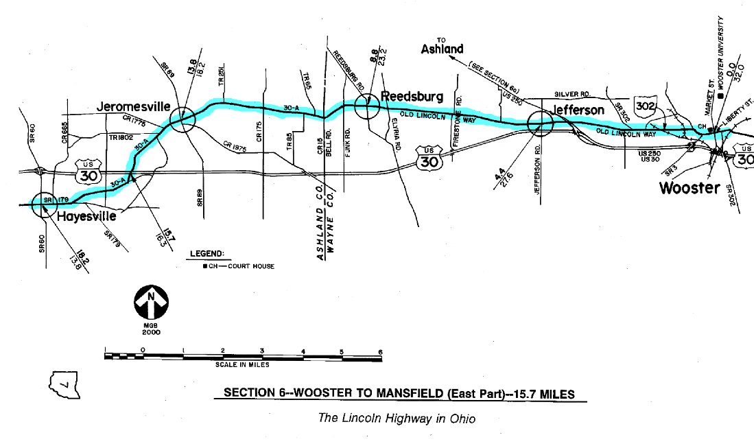
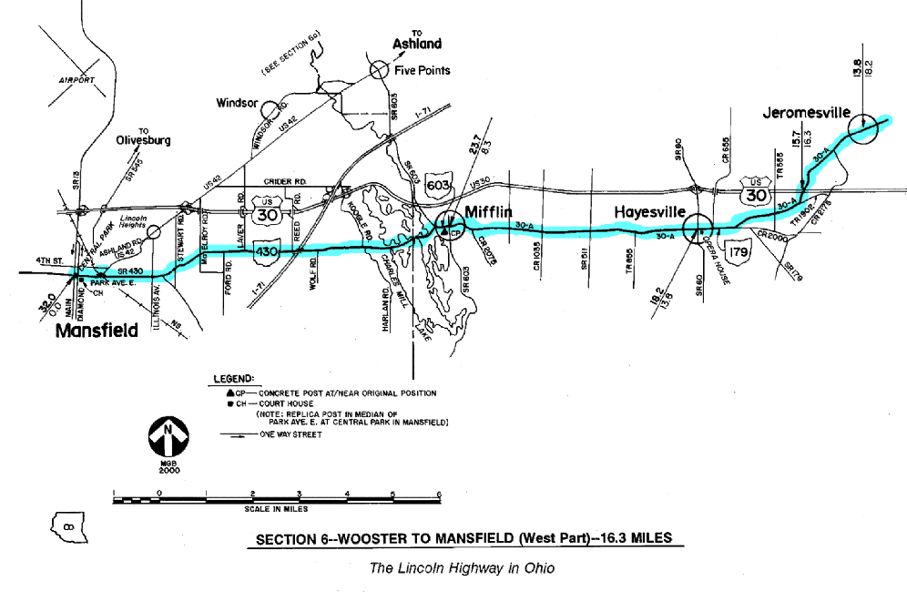
SECTION 6—WOOSTER TO MANSFIELD—32.0 MILES
The route of the 1928 Lincoln Highway between Wooster and Mansfield is probably the best scenic section to travel on this route across Ohio. Now thirty years removed from the busy traffic of U.S. Route 30, this section has truly retained much of the same rural character that would have made it appealing to drive in those early days of the Lincoln Highway - offering sweeping views like those in eastern Ohio, but without the distraction of through traffic.
In 1928, this section was also one of the newest sections of the Lincoln Highway in Ohio. From 1913 to 1928, the Lincoln Highway route from Wooster to Mansfield had been by way of New Pittsburg, Rowsburg, and Ashland, with the inevitable detours of the day sometimes creating variations. That route today would be the equivalent of earlier versions of what are now U.S. Route 250 and U.S. Route 42, including a fine old alignment on what is now Windsor Road, which passes through the community of Windsor [see §6a]. In March of that year, the Lincoln Highway Association approved a revision of the route to a course by way of Reedsburg, Jeromesville, Hayesville, and Mifflin, resulting in a distance reduction of three miles. However, the marking of the new route was delayed until September, when the Boy Scouts set concrete posts along the entire coast-to-coast route. It is interesting to note that State Consul Frank Hopley was apparently not made aware of this route change until after the posts were set, stating that he "was not a little surprised to note [that the route] had been changed east of Mansfield."
The locations of all the concrete markers had been charted by Gael Hoag, the long-time field secretary of the Lincoln Highway Association. Hoag had held this office since the accidental death of Henry C. Ostermann in 1920, and probably knew the route of the Lincoln Highway better than anyone at that time. Unfortunately, only one of the concrete posts set in this section by the Boy Scouts survives in its original position. The post is near the southwest corner of the central intersection in Mifflin, at the junction of State Route 430 (Maine Street) and State Route 603 (Ohio Street). It is the third of the three concrete posts in Ohio which are at or near their original positions.
When the State of Ohio created its system of Inter-County Highways, this route was designated as I.C.H. #146, or Mansfield-Wooster Road. It was not part of Main Market Route No. 3, which passed through Ashland. In later years, this route assumed the designations of State Route 10, which was also known as the Harding Highway, and ultimately U.S. Route 30. Note that State Route 5, like Main Market Route No. 3, would have followed the "Ashland Route."
Today, this same section of the 1928 route has several different designations, due to the fact that it is in three different counties. In Wayne County, the route, once outside of Wooster, is designated Old Lincoln Way (a.k.a. County Road 30A). In most of Ashland County, it is County Road 30A, save for a one- mile segment east of Hayesville that is now part of State Route 179. In the westernmost part of Ashland County, and through Richland County to Mansfield, the old route is now renumbered as State Route 430. Note that when renumbering certain routes, ODOT sometimes "hides" the old highway number within the new number. Another example is State Route 309 west of Mansfield, which had been U.S. Route 30-S.
Between Jeromesville and Hayesville, the 1928 route is intersected at grade by the present four- lane version of U.S. 30. This particular routing, from a point "below" Wooster to a point "above" Mifflin, was opened in the mid-1960s. However, this project was not completely built to the standards of the U.S. Interstate Highway System, as has been the case with several U.S. 30 projects. Whereas some limited access sections of U.S. Route 30 have grade separations and interchanges throughout, the policy here was to design and construct intersections at grade with many of the side roads.
One typical feature not found in this section is old road remnants. Over the years, the highway department was apparently satisfied with the roadway alignment just as it was. West of Mifflin, the Charles Mill Lake and Dam projects probably altered the route at least a little, and research continues with that thought in mind—although some potential remnants may have been submerged.
What can be witnessed are the activities of the Mid-Ohio Chapter of the present-day Lincoln Highway Association, which has posted modern renditions of the standard red, white, and blue Lincoln Highway signs at strategic points along the route. This chapter has been one of the most active chapters in the entire United States in its promotion and preservation of the Lincoln Highway as a historic landmark.
Upon reaching Mansfield, the tourist has arrived at the second largest city on the 1928 route of the Lincoln Highway in Ohio. It is a city which has had an interesting and colorful history with respect to the different Lincoln Highway/U.S. 30 routes through town. For example, between 1920 and 1928 the route through downtown was entirely on Fourth Street, although most folks, and several merchants, considered Park Avenue the main east-west street of the city. The Richland County Court House and Central Park, plus a number of banks, churches, and hotels were on this main thoroughfare, and the street had been part of the original Lincoln Highway that continued west to Galion. The story goes that the merchants on Park Avenue, under the cloak of darkness, would move the Lincoln Highway signs which were posted on Fourth Street over to favored locations on Park Avenue.
When the "Ashland Route" was suddenly abandoned in 1928, Park Avenue did again become an official part of the Lincoln Highway. After passing through downtown on Park Avenue, the newly-marked route jogged at Western Avenue, rejoining Fourth Street, and resuming westerly toward Crestline. Downtown Mansfield was later the eastern junction point of the federal routes of U.S. 30-N and U.S. 30-S. With the designation of these routes, the previous "jog" at Western Avenue was apparently shifted to Main Street, in the center of town. Later, when "one way" streets were marked, other downtown streets also carried the federal markings.
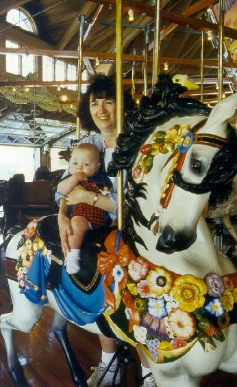
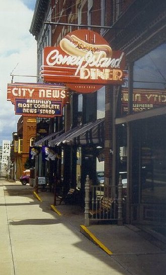 Two blocks north of Mansfield's Central Park is the Carrousel District. At Richland Carrousel Park, kids of all ages (left) can "ride the first new hand-carved wooden carrousel to be built and operated since the early 1930s." Nearby is the Coney Island Diner (right), a local landmark which originally opened in 1936.
When exploring Mansfield, the tourist should note the directions of these one way streets. Main Street, which runs along the west side of Central Park, is one way southbound, and Diamond Street, which runs along the east side of Central Park, is one way northbound. This is important to consider when planning to visit the wonderful Carrousel District, which is centered two blocks north of Central Park at the Main Street/Fourth Street intersection.
Regarding Central Park, it should be noted that Park Avenue did not always pass through the park as it does now. Prior to a construction project in the late 1950s, traffic jogged around the square which can still be traced between Diamond Street and Main Street. This project was unpopular in some circles, as is the case whenever a long-standing landmark is altered, moved or removed. The Vasbinder Fountain, donated to the city in 1881, was removed from the center of the park in 1958. It was restored and relocated back into the park in 1979.
Interestingly, there is a monument to Abraham Lincoln located in Central Park, but it is not a monument directly relating to the Lincoln Highway. This memorial was erected here because of the claim that this park was the site where Lincoln's name was first suggested for the presidency - a claim which has since been disputed.
 Located in the median of Park Avenue East, this concrete replica post in Mansfield is the first of five replica posts that have been set in Ohio. Similar posts have also been set in Canton, Delphos, Jeromesville and Hanoverton.
A recent addition to the several monuments in Central Park is a replica version of the concrete posts set in 1928, and the first of its kind to be set along the highway in Ohio since that time. This new post was constructed and set in April 1996 by Richard Taylor, a local resident and member of the Mid-Ohio Chapter of the Lincoln Highway Association who has built a wooden mold which is being used to cast additional concrete posts for placement along the route. Taylor has been instrumental in the restoration of several Lincoln Highway monuments in Ohio, including the brick pillars at Crestline, and the stone memorial at Bucyrus. By June 1997, at the Fifth Annual National Conference of the Lincoln Highway Association, Taylor and his chapter had attached a plaque to the south face of the Mansfield post for its official dedication.
Because this section between Wooster and Mansfield was such a late addition to the coast-to- coast route, it was generally not a part of the route of the U.S. Army's Transcontinental Motor Convoy. However, there is one interesting story that is somewhat pertinent to this section which came about as a result of that historic event. Although at times it seems that the army engineers may have had to make up the route as they came west—not necessarily following any version of the Lincoln Highway—it is known that they did make news in the town of Olivesburg. In 1919, Olivesburg was apparently on the best route from Ashland to Mansfield insofar as the army convoy was concerned. On July 15, one of the army tank trucks crashed through a bridge in Olivesburg, which delayed the convoy's arrival that day in Bucyrus. Up to the task, the army engineers reportedly left the town that day "with a sound, new bridge where the old one was."
One young officer who was part of the convoy's transcontinental journey was Lt. Col. Dwight D. Eisenhower, who would later become the thirty-fourth president of the United States. In 1954, during the first of his two terms, Eisenhower established a President's Advisory Committee on a National Highway Program. The resulting report from this committee eventually led to the Federal Aid Highway Act of 1956, which established the now-familiar Interstate Highway System. Eisenhower had become an advocate for such a system of national defense highways after witnessing first-hand the efficiency of Germany's Autobahn during his tenure as Allied commander in World War II. It is thus appropriate that this system of highways is officially known today as the Dwight D. Eisenhower System of Interstate and Defense Highways.