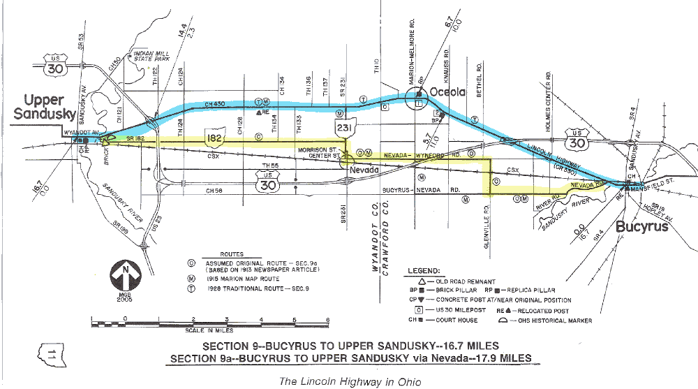
SECTION 9—BUCYRUS TO UPPER SANDUSKY—16.7 MILES
The route of the 1928 Lincoln Highway between Bucyrus and Upper Sandusky enters the homelands of the last group of Indians to leave Ohio. This was the home of the Wyandot tribe until their removal to the west in 1842. Earlier rewarded for their loyalties to the Americans during the War of 1812, the Wyandots had been granted a reservation area of about 228.5 square miles, plus a mill near the center of the reservation along the Sandusky River.
An area near this mill would later become the town of Upper Sandusky. Today, the main east-west street and the "traditional" route of the Lincoln Highway is appropriately Wyandot Avenue, and Upper Sandusky is the seat of government of Wyandot County. Take time to visit to the Wyandot County Court House, which has perhaps the most beautiful interior of the several courthouses on the route of the Lincoln Highway in Ohio. Northeast of town, the Indian Mill State Memorial, built in 1861 to replace the previous mill, houses the nation's first educational museum of milling.
Construction of the present Crawford County Court House in Bucyrus actually began in 1854, a decade before the Civil War. The addition of a rear wing in 1893 and the enlargement of the front in 1909 have obscured the original structure. The stone pillars and copper dome are replacements of previous features.
Bucyrus, which was platted in 1822, was one of the earliest settlements in this part of the state, and became the seat of government for Crawford County. Its importance in the development of northwestern Ohio was enhanced by being on the route of the Columbus and Sandusky Turnpike, laid out in 1827, and by the survey of the Bucyrus and Fort Wayne State Road in 1835. However, it is interesting to note that the road to Fort Wayne passed through the settlement of Little Sandusky—several miles south of Upper Sandusky—on its way to Williamstown, Van Wert, and points west. Diagonal portions of Township Road 96 and County Road 85 in southwestern Wyandot County may be two remaining parts of the alignment of that first road to Fort Wayne.
 This former Texaco station in Bucyrus is one of my favorite examples of old roadside architecture along the route.
The roadway from Bucyrus which actually became the route of the 1928 Lincoln Highway was part of an early road to Perrysburg, the original county seat of Wood County. Located on the Maumee River about ten miles upstream from present-day Toledo, the town of Perrysburg was laid out in 1816 as one of the first settlements in northwestern Ohio. A small remnant of diagonal roadway northwest of Oceola, which is designated Perrysburg Road, is one of the last reminders of the old road.
The towns of Oceola and Upper Sandusky were apparently connected about the time when Oceola—named by its proprietors for the chief of Florida's Seminole tribe—was platted in the 1830s. Wyandot County road records indicate that the Bucyrus and Upper Sandusky Free Turnpike, which passed through Oceola, was changed by the county commissioners to a "State Road" in the mid-1840s. Also of significance here is the transfer of interests of the Oceola and Bucyrus Plank Road to the commissioners of Crawford County, which occurred in 1866.
When Henry Joy announced his route correction of October 1913, it appears that his original intent was to locate the route through Oceola. However, based on several route guides, including those published by the Lincoln Highway Association, the first route marked between Bucyrus and Upper Sandusky was through Nevada (pronounced nuh-VAY-duh, like the town in Iowa which annually hosts "Lincoln Highway Days"), which is 1.5 miles to the south. Oceola was probably not on the Lincoln Highway route until 1921, when the last stretch of brick paving was completed across Crawford County.
|
SECTION 9a—BUCYRUS TO UPPER SANDUSKY via Nevada—17.9 MILES There were at least two versions of the route to Nevada, apparently depending on prevailing conditions and improvements of the day. Both versions left Bucyrus on the Bucyrus-Nevada Road and entered Nevada on what is now Nevada-Wynford Road (Township Road 55 in Wyandot County). Variations occurred in getting from one road to the other—the earliest variation used Glenville Road (described in Bucyrus Journal in January 1914), and the later version used what is now Marion-Melmore Road (shown on a map prepared in 1915 by a delegation from Marion who tried to get their city back on the route). Both versions required a crossing of the Pennsylvania Railroad. These one-mile jogs and railroad crossings were no longer necessary when today's Nevada-Wynford Road (originally Inter-County Highway #490) was extended easterly from Glenville Road to the "Oceola Road" at about this same time. It is uncertain whether this extension was ever part of the Lincoln Highway. Map It almost seems that there may have been a new route for every new driving season in this area. For instance, the 1920 Automobile Blue Book charts yet another route that follows the Oceola Road as far west as Bethel Road, where it "dropped" south to rejoin the road to Nevada [see Appendix E]. But like the extension of the Nevada-Wynford Road, it is not apparent whether this was an official Lincoln Highway routing. Multiple routes also prevailed between Nevada and Upper Sandusky. The 1921 Official Road Guide shows a route that approaches Upper Sandusky by way of today's State Route 182, which agrees with the route described in the Bucyrus newspaper in 1914. The 1915 Marion map delineated a route that follows today's State Route 231 and U.S. Route 30. Rather than duplicate the western part of the route charted for Section 9, the charted course for the alternate section follows the 1914/1921 version. The 1915 routing was probably a temporary version which was the best route at that time. |
There are two important Lincoln Highway landmarks along the roadway in this section of the "traditional" route. The first landmark is one of the original concrete posts placed by the Boy Scouts. From 1928 to 1997, this post was located in the "triangle" of the Mary Street intersection at the west edge of Bucyrus. In 1997, the post was moved to the town square in downtown Bucyrus. Another post from the west end of this section has also been saved, but has been removed from alongside the route and placed on the grounds of the Wyandot County Historical Museum, at 130 S.Seventh Street in Upper Sandusky.
The second important landmark is the brick pillar that is one mile easterly from the crossroads in Oceola. Of the four pillars which remain along the Lincoln Highway in 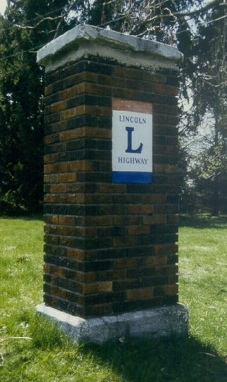 Ohio, this is the only pillar that does not have a dedication plaque. It was set in 1921 to commemorate the completion of the bricking of this part of the highway, and is the only survivor of what may have been eight pillars in Crawford County west of Bucyrus. Past-President Esther Oyster has determined that these brick pillars were set at one-mile intervals, in a span of seven miles from Bucyrus to the Wyandot County Line, and has thus far been able to verify the construction of six of these pillars.
This pillar, one mile east of Oceola, was dedicated in 1921 to commemorate the completion of brick paving across Crawford County.
The first of these brick pillars was at the Bucyrus city limits, 0.7 miles west of the town square (or 7.0 miles east of the county line), and was known as the Hopley Marker. This marker was dedicated on November 28, 1917, and like the stone memorials on the east side of Bucyrus, was dedicated to John E. Hopley, state consul of the Lincoln Highway Association. Had this pillar survived, it would stand nearly opposite the concrete post at the Mary Street "triangle." Unfortunately, the pillar was hit by a car and demolished in 1922; however, the base of the pillar, although slightly turned on its foundation, still remains. The marble dedication plaque from the face of this pillar is now in the Bucyrus Historical Museum.
A second brick pillar, one mile west of the Hopley Marker location, was known as the Ostermann Marker, and was apparently destroyed by an unhappy landowner who did not want the marker in front of his farm. This marker was also dedicated on November 28, 1917, and honored the popular Henry C. Ostermann, who was the first field secretary of the Lincoln Highway Association. In 1920, Ostermann was tragically killed when his car overturned in a traffic accident on the Lincoln Highway in Tama County, Iowa. He is buried in Riverview Cemetery in East Liverpool, which was his wife's home town.
A third brick pillar, apparently three miles west of the Hopley Marker location, has been verified in an old photograph. Thus far, no other information has been found.
A fourth brick pillar, five miles west of the Hopley Marker location, is the pillar near Oceola, described above. A good way to anticipate the location of this marker is to watch for the milepost 2 sign along U.S. Route 30. The brick pillar is about 200 feet easterly from this sign, and on the same side of the road. It is also at the top of a side slope, and is sometimes obscured by the leaves of a catalpa tree.
A fifth brick pillar, six miles west of the Hopley Marker location, was at the northeast corner of the crossroads in Oceola. Sadly, this pillar was demolished in the summer of 1993 by a van which left the roadway. Happily, the red, white, and blue Lincoln Highway sign was saved, and has since found its way to a museum in Delphos.
A sixth brick pillar, seven miles west of the Hopley Marker location, was located at the southeast corner of the Crawford/Wyandot County Line Road. This location is based on old survey crew field notes from the Ohio Department of Highways (now Ohio Department of Transportation). Thus far, no other information has been found.
There is evidence from that same book of field notes that at least five brick pillars were set in eastern Wyandot County; however, none of these markers remain today, except in old photographs. Using the Sandusky River bridge in Upper Sandusky as the "zero" point for their survey measurements, the surveyors located these pillars from west to east as follows:
1. On the north side of the road, at 2.17 miles east of "zero";
2&3. On the south side of the road, on each side of the driveway to the old Kuenzli house, at 3.53miles east of "zero";
4. On the northwest corner of the intersection with County Road 128, at 4.42 miles east of "zero"; 5. On the southeast corner of the intersection with State Route 231, at 7.44 miles east of "zero."
A brick pillar was also set in the west part of Upper Sandusky at the corner of Wyandot Street and Eighth Street, with the traditional plaques on at least two sides. Another pillar is reported to have been at the corner of Wyandot Street and Warpole Street. This would make sense because no concrete posts were called for at this turn in 1928. The existence of a pillar may have eliminated the need for additional markers. Other brick pillars may have been set between Upper Sandusky and Beaverdam, although research here has been inconclusive, if not difficult. In the summer of 1999, Ohio's first brick pillar 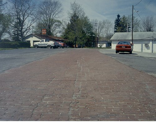 replica was erected by city forces at the southeast corner of Wyandot Avenue and Fourth Street in Upper Sandusky.
In July 2000, the Ohio Bicentennial Commission awarded the Ohio Lincoln Highway League with a historical marker that will be placed at  this brick road remnant in Upper Sandusky.
The Ohio Lincoln Highway League is proud to be associated with the Ohio Bicentennial Commission.
The most interesting feature remaining in the Wyandot County portion of this section is the old remnant of brick roadway near Upper Sandusky. An Ohio Historical Society marker was placed alongside this landmark in the fall of 2000. The old road remnant is sixteen feet wide, with cement borders, and is located just east of the new bridge over the Sandusky River (or 0.6 miles easterly from the courthouse), behind the grocery store and in front of the radio station. This had been the location of an earlier Lincoln Highway alignment, before a previous bridge (George Washington Bridge) and approaches were constructed in about 1931. The new approach on the east side of the river was built on new fill, and eliminated a sharp curve that had previously existed at another earlier bridge. The story goes that some of the paving bricks taken up from the old highway were used to build the county highway garage on the west side of Warpole Street. The George Washington Bridge, a photogenic spandrel filled arch structure, was originally built after the untimely collapse of the old Red Bridge, a steel truss structure that went down with a Studebaker semi-truck on May 27, 1931.
 Built after the collapse of the Red Bridge in 1931, the George Washington Bridge in Upper Sandusky was itself replaced in 1998.
Historically, this section of the 1928 Lincoln Highway was originally designated as Inter-County Highway #200, or Bucyrus-Upper Sandusky Road. It was later assigned the State Route 5 and U.S. Route 30-N markings typical of all the sections between Mansfield and Delphos. The final U.S. 30 numbering came about in November 1973. Crawford County has marked the present U.S. Route 30 as Lincoln Highway on its white-on-green road name signs, and Wyandot County has designated their two-lane portions of the present U.S. 30 as "USH 30." A bypass route of U.S. 30 was opened in November1993 around the north side of Upper Sandusky, overlapping part of four-lane U.S. Route 23.