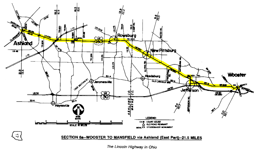
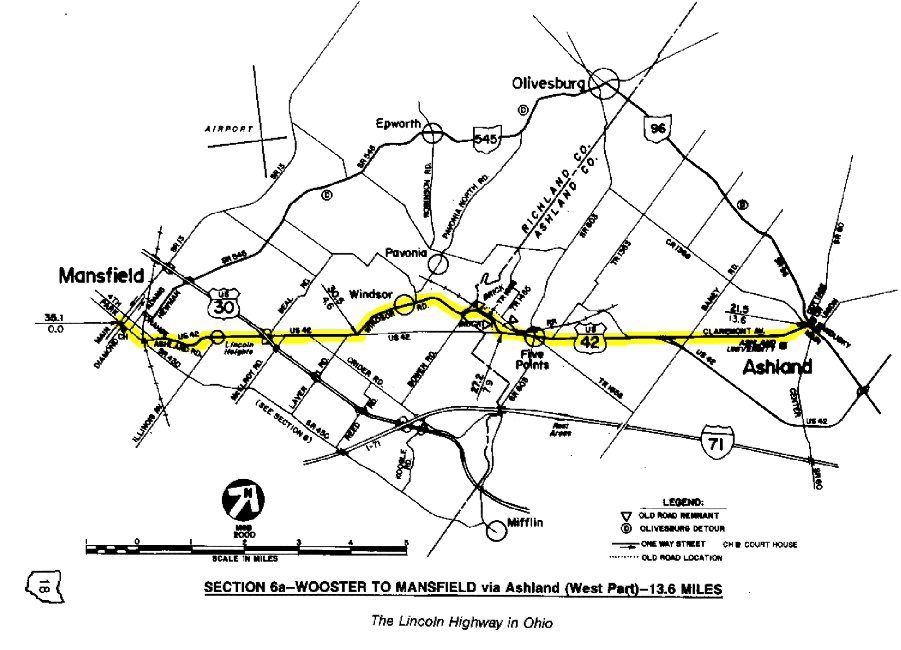
SECTION 6a—WOOSTER TO MANSFIELD via Ashland—35.1 MILES
Between 1913 and 1928, the route of the Lincoln Highway passed through the city of Ashland, the county seat of Ashland County. Ashland was one of nine county seats that were on the route
 The Ashland County Court House is on a prominent block of high ground in Ashland, one block north of the pre-1928 Lincoln Highway. Completed in 1929, it is a rare example in Ohio of late Neoclassical or Art Deco architecture. Conspicuous by their absence are the typical dome, clock and statue of the Goddess of Justice.
of Main Market Route No. 3, which provided the framework for most of Ohio's original Lincoln Highway route. After 1923, most of the market route was also known as State Route 5, but when federal designations were assigned in 1926, it was the southern route through Hayesville, Jeromesville, and Mifflin that received the U.S. 30 designation.
Bearing westerly from Wooster, this early route was duplicated by the 1928 route until reaching the crossroads community of Jefferson, where it turned north on today's Jefferson Road, an early version of U.S. 250, which now bypasses Wooster. This was also the path of Inter-County Highway #141, or Wooster-Ashland Road. One-half mile north of Jefferson, the early route turned west again onto today's Silver Road at Dead Man's Curve, following that road to its end at a modernized version of U.S. 250.
Bearing northwesterly toward Ashland, U.S. Route 250 almost completely follows its original course, passing through New Pittsburg and Rowsburg without the delay of a single stop sign or stop light. The only remnant in this section visible from the roadway is a brick driveway one-half mile west of Rowsburg that was rendered by the improvement of a reverse curve at a stream crossing.
The U.S. 250 designation first appeared on the highway maps of Ohio in 1929, apparently as a late addition to the federal highway system. Prior to that, the section between Wooster and Ashland carried the dual designations of both State Route 5 and State Route 6. Just as much of State Route 5 in Ohio became parts of U.S. 30, most of State Route 6 became parts of U.S. 250.
Five miles east of Ashland, a monument on the north side of U.S. 250 identifies the site of the Studebaker homestead and shop, built in 1835. Three sons of John Studebaker were born here, and would become the founders of the Studebaker Institution in South Bend, Indiana.
In Ashland, the Lincoln Highway followed Main Street into downtown and turned southwesterly toward Mansfield on Claremont Avenue. The Ashland County Court House is one block north of this intersection—an unusual case where the court house is not directly on a main thoroughfare. At one time, Main Street was Lincoln Way East and Claremont Avenue was Lincoln Way West, but those names long ago vanished into history.
Southwest of Ashland, Claremont Avenue merges into U.S. Route 42 as it bears toward Mansfield. However, the old Lincoln Highway route does not completely follow the present route of U.S. 42. The old road actually passed through the community of Windsor, on ground that was more high and dry than the present alignment through the "flats"—one that borrowed part of the roadbed of an abandoned interurban right-of-way. The old road is now known as Township Road 1688 in Ashland County and Windsor Road in Richland County, and the keen eye can still observe some exposures of original brick along the edge of the road which may date back to the late 1910s. More apparent is a short stretch of brick on a "fill"  section which was the approach for an overpass of the interurban.
This old brick road remnant along Windsor Road was the approach to the crossing of an old interurban railroad between Mansfield and Ashland. At its peak, Ohio had more interurban track mileage than any other state.
Another highlight on Windsor Road is the Mail Pouch barn that L.H.A. member Richard Taylor had painted as an anniversary gift for his wife Mary Lou. This barn was painted by 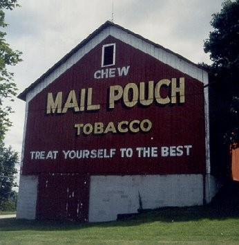 Harley Warrick, the last in a long line of Mail Pouch painters. Warrick claims to have painted about 20,000 barns.
LHA member Richard Taylor has this Mail Pouch barn painted for his wife Mary Lou as an anniversary present. It was painted by Harley Warrick, who claims to have painted over 20,000 such barns.
Although the charted course at the east end of Windsor Road now follows the south side of the old Erie Railroad embankment, another alignment which predated the interurban crossing was on the north side of the railroad. Thus, the railroad was crossed twice within a one mile distance after diverging from the present route of U.S. 42 near Five Points (at junction with S.R. 603). Part of this first alignment exists today as the east end of Township Road 1455. The remainder has blended into fields and fence lines.
In Mansfield, the Lincoln name still survives in the northeast part of the city as a reminder of the highway's original location. Two churches in the Lincoln Heights area continue to use the neighborhood name as part of the church name. There is also a Lincoln Inn, despite the fact that within the Mansfield city limits, the roadway is now known as Ashland Road.
Through Mansfield, the charted course for this alternate section follows Park Avenue, as it did from 1913 to 1920. By following Park Avenue, the tourist can continue with charted courses for both the 1928 route to Crestline [§7] and the earlier route to Galion [§7a]. Park Avenue also traverses the heart of downtown Mansfield, and passes a concrete replica post in Central Park just east of the Main Street intersection. From 1920 to 1928, the route from Ashland would have followed Fourth Street, which today passes through the wonderful Carrousel District before continuing westerly toward Crestline.