BY THE NUMBERS
A CHRONOLOGY OF THE FEDERAL HIGHWAYS IN OHIO
Part two of this series is also
included, featuring the history of state routes and their numbering in Ohio.
Michael G. Buettner
November 18, 1925--A report from the U.S. Department of
Agriculture/Bureau of Public Roads was approved on this date by the Secretary of
Agriculture. Many maps dated 1926 show these tentative routes, including the
Ohio Department of Highways (ODH) map of that year. These are the numbers of the
proposed routes which were in Ohio: 20 21 22 23 24 25 27 30 40 42 50 52 127.
 Click to view 1926 Ohio Department of Transportation map oddity.
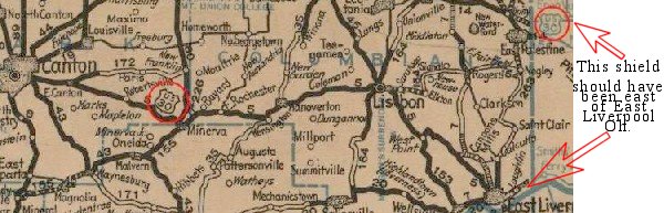
An oddity on the 1926 ODH map shows US30 shields in two places east of Canton:
one on the main road west of Minerva; another on the road into Pennsylvania from
East Palestine. Unless one of the shields is erroneously located, the route east
of Lisbon must have been a horrible one. No shield is shown in the vicinity of
East Liverpool, where the route was first signed in the field.
A route numbered 121 between Cleveland and Lisbon was not shown on the ODH map
and was apparently dropped from the Bureau's proposal earlier in 1926. Most of
the route locations as described in the report would be recognized on Ohio maps
well into the 1970s, with the following exceptions:
US20 was the original transcontinental route ending at Astoria, Oregon, not
US30. The proposed terminus for US30 in the 1925 plan was at Salt Lake City.
This would change by the time the American Association of State Highway
Officials (AASHO) approved the plan.
Also, the first version of US127 terminated at Toledo, but in 1932 was
designated for a new route to Cincinnati. The original US127 was renumbered as
US223.
November 11, 1926--AASHO accepts a modified plan for the first federal highway
system. Numbers in use for Ohio are as follows: 20 21 22 23 24 25 27 30 40 42 50
52 127 322 422
US322 and US422 were addenda to the 1925 plan. US22 was originally proposed to
terminate at Cleveland, but was modified to terminate at Cambridge. The
Cleveland endpoint was accomplished by two three-digit branch roads which
diverged from US22 in Pennsylvania.
 Relative to Ohio, the other proposed routes had no drastic changes, although
many routes were lengthened beyond her borders. US30 became the route of the
Lincoln Highway through much of Ohio, but not nearly as much as one might think.
US30 took the southern route across Ashland County, through Jeromesville and
Hayesville, and also varied from the traditional Lincoln Highway by reviving the
old main market route through Galion, Marion, Kenton, and Lima. Another
variation was between East Liverpool and California Hollow Junction in
Columbiana County.
Relative to Ohio, the other proposed routes had no drastic changes, although
many routes were lengthened beyond her borders. US30 became the route of the
Lincoln Highway through much of Ohio, but not nearly as much as one might think.
US30 took the southern route across Ashland County, through Jeromesville and
Hayesville, and also varied from the traditional Lincoln Highway by reviving the
old main market route through Galion, Marion, Kenton, and Lima. Another
variation was between East Liverpool and California Hollow Junction in
Columbiana County.
The Lincoln Highway crossed four of these original federal routes:
21 at Massillon; 42 at Mansfield; 23 at Upper Sandusky; 25 at Beaverdam.
Interestingly, US30 was the longest of all the new federal routes, traversing
3472 miles from Atlantic City, New Jersey to Astoria, Oregon. It was rivaled
only by US40 (3205 miles from Atlantic City to Oakland, California) and US50
(2856 miles from Annapolis, Maryland to Sacramento, California). US20 in its
original form terminated at Yellowstone National Park in Wyoming, only 2542
miles west of Boston. Isn't it odd that two transcontinental routes started at
Atlantic City?
Also fascinating is the fact that Ohio had a nice straight run of numbers—20,
21, 22, 23, 24, 25.
For what it is worth, Ohio could boast of having the longest "straight" well
into the early history of federal numbers. Later, several new or extended routes
gave Texas the right to that claim with an impressive "hand" of numbers from 79
through 85.
1929—The first new number to show up in Ohio's federal scheme was US250, which intersected US30 at Wooster. Although its original termini were at Grafton, West Virginia and Norwalk, Ohio, it was later extended to Richmond, Virginia and Sandusky, Ohio.
 Soon to become the
intersection of US 250 and US 30.
Lincoln Highway Collection, Transportation History Collection,
Special Collections Library, University of Michigan.
Soon to become the
intersection of US 250 and US 30.
Lincoln Highway Collection, Transportation History Collection,
Special Collections Library, University of Michigan.
1931—The route of US127 between Lansing, Michigan and Toledo, Ohio was
renumbered as US223, thus rendering it a branch of US23 instead of US27. A new
US127 was designated between Lansing and Cincinnati, crossing the Lincoln
Highway at Van Wert.
Also in 1931, US30 between Mansfield and Delphos was split into two routes of
equal importance, US30-N and US30-S. This was a carryover from the early days of
the Lincoln Highway, when Marion interests, miffed by Henry Joy's quick-trigger
1913 rerouting, created what would become the Harding Highway. US30-N put
Bucyrus and Upper Sandusky on an east-west federal route for the first time.
Although AASHO despised them, compromising suffixes like these were nothing new.
In fact, the original 30-N and 30-S numberings had existed for four years in
western Wyoming.
In Ohio, north and south suffixes were in use for US50, and soon there would be
a US20-N (later US20-A). Only US40 seemed to escaped the suffix problem for the
major east-west routes crossing Ohio.
1932—Three new federal routes show up for the first time on the ODH map of 1932.
Routes 6, 36, and 62 are added. Most significant is US6, which meandered from
Cape Cod to Colorado. Eventually this route would reach Long Beach, California,
traversing 14 states and 3517 miles, overtaking US30 as the longest federal
highway. The only other routes that passed through fourteen states were US1,
US40, and US50. US30 passes through only twelve states.
In later years, US30 would similarly drop behind US20 and US50 in terms of
mileage. Those routes were extended west to the Pacific Coast at Newport, Oregon
and San Francisco, California, respectively, and US50 eventually reached the
Atlantic at Ocean City, Maryland.
US6 is known as The Grand Army Of The Republic Highway, and is often marked as
such in Indiana. It is rare to see such a sign in Ohio, where it is not within
state standards to have a "named road" sign displayed on a numbered route.
US36 in its original form was between Indianapolis, Indiana and Colby, Kansas.
In its longest, and frustratingly meandering form, it stretched from Cadiz, Ohio
to Denver, Colorado, tracing much of the corridor of the old Pikes Peak
Ocean-To-Ocean Highway.
At Canton, US62 became the seventh federal route to cross the Lincoln Highway
and US30. It traversed 2289 miles from Niagara Falls, New York to El Paso,
Texas.
1933—Another new route appeared on the Ohio map the following year. US68 finally
escaped the borders of Kentucky, bridging the Ohio River at Maysville, Kentucky
before continuing north to Toledo. It crossed the Lincoln Highway at the small
community of Williamstown. This route followed in the footsteps of a proposed
US125, which would have been a branch of US25 between Findlay, Ohio and
Maysville.
1934—Yet another new route was created across Ohio, this time as a branch of
US24. US224 was designated between New Castle, Pennsylvania and Huntington,
Indiana. It was the ninth route to have a junction with US30 in Ohio. This
meeting was at Van Wert, where it shared the path down Washington Street with
US127. Thus, Van Wert was the only Lincoln Highway town in Ohio where two
federal routes crossed the Lincoln Highway.
1935—For the third consecutive year, a single federal route was added to the
federal scheme in Ohio. US35 cuts a diagonal across southwestern Ohio between
Charleston, West Virginia and Michigan City, Indiana, and crosses the Lincoln
Highway in the middle of nowhere in Starke County, Indiana.
1938—The last federal route to be marked in Ohio was US33, another diagonal
route which was more or less parallel with US35. Its termini were Richmond,
Virginia and St. Joseph, Michigan, and its junction with US30 is at Fort Wayne,
Indiana, where US27 also crosses.
1970s—As the construction of the main routes of the Interstate Highway System
neared completion, many of the federal routes became redundant, or were rendered
of secondary importance. Because much of US21 and US25 had been superseded in
Ohio by I-77 and I-75, respectively, those federal numbers were dropped from the
scheme. State Routes 21 and 25 are now the shortened reminders of their past.
Between Mansfield and Delphos, the shorter US30-N corridor was the one improved
to become a four-lane highway. Thus, the "cumbersome compromise" of suffixes was
finally dropped in November 1973, with US30-N becoming US30 and US30-S becoming
State Route 309. Another three-digit number which serves as a reminder of its
US30 heritage is State Route 430 near Mansfield.
After US50-N became State Route 550 in southern Ohio, all of the old suffixes
had finally been eliminated with the exception of US20-A, which survives west of
Toledo. The US30-A designation at Dalton is a mystery of sorts—it shows up with
a shield for the first time on the ODH map of 1962, although the Dalton bypass
had been built for about ten years.
HERE ARE SOME PARTICULARS FOR OHIO'S ORIGINAL FEDERAL HIGHWAYS (1927)
20 Boston, Massachusetts to Yellowstone National Park, Wyoming—2542 miles
21 Cleveland, Ohio to Yemassee, South Carolina—793 miles
22 Elizabeth, New Jersey to Cambridge, Ohio—490 miles
23 Mackinaw City, Michigan to Portsmouth, Ohio—625 miles
24 Pontiac, Michigan to Kansas City, Missouri—771 miles
25 Port Huron, Michigan to North Augusta, Georgia—792 miles
TRIVIA: Note that in the original federal scheme, two-digit roads ending in 1 were the major north-south routes, not those ending in 5. Although US25 eventually stretched 1151 miles between Port Austin, Michigan and Brunswick, Georgia, it was considered secondary in its original form to routes such as US21 and US31.
27 Cheboygan, Michigan to Cincinnati, Ohio—516 miles
30 Atlantic City, New Jersey to Astoria, Oregon—3472 miles (crosses 12 states)
40 Atlantic City, New Jersey to Oakland, California—3205 miles (crosses 14
states)
42 Cleveland, Ohio to Cincinnati, Ohio—243 miles
50 Annapolis, Maryland to Sacramento, California—2856 miles (crosses 14 states)
52 Huntington, West Virginia to Fowler, Indiana—343 miles
MINUTIA: The only federal route in Ohio that terminates in an international boundary is US52, which now ends in the US/Canada line at Portal, North Dakota. Many routes terminate at coastal cities, but this is the only route which ends at our national border.
127 Lansing, Michigan to Toledo, Ohio—77 miles
322 Water Street, Pennsylvania to Cleveland, Ohio—226 miles
422 Ebensburg, Pennsylvania to Cleveland, Ohio—203 miles
In 1912, the State of Ohio's Highway Department published their first map
showing numbered roads. That numbering system was the first of five different
systems that have been used in Ohio since that time. Part one highlighted the federal numbering system.
This part will discuss the other four numbering systems which have been or are
being used in Ohio.
The 1912 highway map of Ohio was titled "Map Of Ohio Showing Inter-County
Highways" and identified 444 inter-county highways such as ICH #12, known as
Cleveland-East Liverpool Road, and ICH #146, known as Mansfield-Wooster Road.
Most of the inter-county routes had the character of the latter, simply
connecting two cities in adjacent counties. Only several of these routes came
close to crossing the entire state. The most notable exceptions were ICH #1,
which was the route of the old National Road, and ICH #7, the Ohio River Road.
At the same time that the inter-county highways came into use, a network of Main
Market Routes was designated by authority of the state legislators. These routes
did cross the state, and in a grid pattern similar to the federal network of
highways that would be marked about fifteen years later. More than twenty of
these market routes were eventually added to the official state highway map,
including Main Market Route No. 3, which supposedly was to be the route of the
Lincoln Highway in Ohio. However, the imperfect overlaps rendered here and there
by Henry Joy became the source of more than one headache—not only with the
seemingly-slighted citizens of Marion and Kenton, but also in Paris Township in
Stark County. These stories are more completely told in A History And Road Guide
Of The Lincoln Highway In Ohio.
It appears that the system of market routes was used only until 1921, because it
disappears on the state map of 1922. Curiously, the market routes went through a
renumbering in 1920, and for a brief time, the route of the Lincoln Highway was
generally the same as a new Main Market Route No. 2. Other market routes would
be familiar to road fans as the future corridors of the Dixie Highway and 3-C
Highway, just to name two.
The network of inter-county highways would outlast the main market routes by
more than twenty years. It was this set of numbers which first appeared on a
state route sign in 1920. Potentially confusing, however, is the fact that the
official sign did not show "Inter-County Highway" as part of the text. Instead,
the marker had "STATE ROUTE" lettered above the route number, with "OHIO"
appearing below. Supposedly the story goes that "INTER-COUNTY HIGHWAY" took up
too much space on the sign. This first sign was actually no more than black and
white paint on a utility pole. By the way, there is no evidence that any market
route was ever signed—it appears that the number was merely a paper designation.
The state route/inter-county language is again potentially confusing because in
1923, Ohio's third system of numbered highways was designated. This system
provided the original framework of the same state route system which survives
today. The confusion lies in the fact that the Department of Highways continued
to use the old inter-county highway numbers for office purposes until 1947.
Thus, all highway projects in that era are referenced to the inter-county
highway number (and state route number of 1920-1922) and not the new state route
number established in 1923. This is important to consider when researching old
bridge and roadway plans. By the time those original numbers were discontinued
in 1947, over 1000 inter-county highways had been designated.
 Click
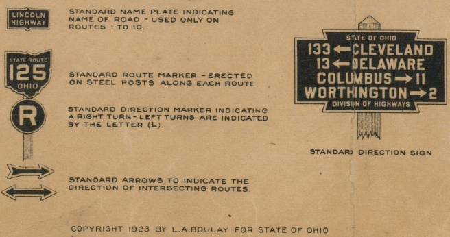
to view. The legend of the 1923 map
(click left) shows the first Ohio route sign to be fabricated and
placed on a post. Although the colors of the sign are not specified here, by
1926 it is known that the signs were black on yellow. In later years, the signs
would revert to the black on white which is still the standard today.
Click
to view. The legend of the 1923 map
(click left) shows the first Ohio route sign to be fabricated and
placed on a post. Although the colors of the sign are not specified here, by
1926 it is known that the signs were black on yellow. In later years, the signs
would revert to the black on white which is still the standard today.
With this new system, the total of numbered roads in Ohio was reduced to 223.
However, it did not take long for the system to be expanded, for by 1935 and
1936, the highest numbered route on the map was State Route #386. Then, an
apparent burst of energy must have struck the highway department. Almost
magically, more than 150 new routes appeared on the 1937 map, with numbers
ranging in the 500s, 600s, and 700s. Note that only half the available numbers
were used here. Many but not all would come into use soon thereafter.
#386. Then, an
apparent burst of energy must have struck the highway department. Almost
magically, more than 150 new routes appeared on the 1937 map, with numbers
ranging in the 500s, 600s, and 700s. Note that only half the available numbers
were used here. Many but not all would come into use soon thereafter.
1926 black on yellow state road signs.
It is not known why the 400 series of numbers was skipped. John Simpson, who
maintains an impressive web site he calls
The Unofficial Ohio State Highways Web
Site, speculates that the 400 series was "reserved for a new state freeway
or toll road system, much like Ontario's 400 series highways.
Although it is not easily discerned, there does appear to have been some method
to the madness of numbering all these state routes. Routes 1 through 10 were
definitely the most important routes, as witnessed by the fact that most would
soon become routes of the federal highway system. The ten routes were also set
apart by having a rectangular "named road" sign above the Ohio shield. The
numberings had a mixture of logic and randomness. State Route 1 remained the old
National Road, and State Route 7 remained the Ohio River Road, and were the rare
exceptions of routes which carried over their previous inter-county numbers. It
also made sense that the 3-C Highway (Cleveland/Columbus/Cincinnati) was
numbered State Route 3. The route
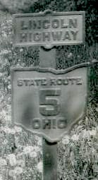 of the Lincoln Highway became State Route 5,
the Dixie Highway was State Route 6, and the Harding Highway was State Route 10.
State Route 11, which did not carry the auxiliary sign, also crossed the state
and formed the backbone of what would become U.S. Route 35.
of the Lincoln Highway became State Route 5,
the Dixie Highway was State Route 6, and the Harding Highway was State Route 10.
State Route 11, which did not carry the auxiliary sign, also crossed the state
and formed the backbone of what would become U.S. Route 35.
Lincoln Highway Collection, Transportation History Collection,
Special Collections Library, University of Michigan.
Starting with State Route 12, tracing the numbering system becomes a fascinating
adventure. It is likely that someone in authority merely sat down, or sat
someone down, at a drafting table or desk and laid out the map of what would
become the 223 routes. This privileged individual then put numbers on the map in
whatever way made the most sense at the time. John Simpson calls it a
"clustering" system.
Note that the original State Routes 12 through 16 all radiated from Cleveland.
Similarly, Routes 19 through 21 from Columbus. It seems that longer routes from
the largest urban areas were given low number priority. Numbers such as 79, 80,
and 81 were used for major routes which criss-crossed the state without entering
the biggest cities.
At this point in the numbering scheme, it appears that the mapmaker turned his
pen to the northeast corner of the state, and commenced to fill in numbers for
all the minor routes nearest the state's perimeter. He worked his way around the
state in a counter-clockwise direction, starting with numbers in the 80s in the
northeast counties. Thus, numbers in the 90s abounded in the north central part
of the state, numbers in the 100s in the northwest corner of the state, numbers
in the 110s in the west central counties, and so forth. By the time the mapmaker
had circled back around to eastern Ohio, he had exhausted all the numbers into
the 150s. It appears he then made another pass across the state, filling in the
numbers for routes of similar importance which were closer to the center of the
state.
It is obvious that by the time the mapmaker reached the 200s, he was labeling
the most minor routes and connecting roads. Other minor routes, connectors, and
access roads to state parks are prominent in the 300 series. Note the numbering
similarities for routes in the vicinity of Indian Lake, Lake Loramie, and Grand
Lake St. Marys. As discussed above, numbers in the 500 through 700 series burst
onto the 1937 map, but seemingly in a scattershot fashion, although some
clustering is evident.
The fourth numbering system effecting Ohio was the first one created by federal
government. This was the federal highway system shown on the Ohio map of 1927,
and included U.S. Route 30 in the corridor of the Lincoln Highway. Again this is
a story more completely told in A History And Road Guide Of The Lincoln Highway
In Ohio, but suffice it to say that the first version of U.S. Route 30 did not
completely follow the Lincoln Highway route traced by State Route 5. The most
notable exception is between Mansfield and Delphos, where the original version
of U.S. 30 followed the Harding Highway, putting Galion, Marion, Kenton, and
Lima back on a route of national prominence after each had been methodically
eliminated from the route of the Lincoln Highway.
The federal numbers for Ohio were more specifically discussed earlier, but it is worth noting that these new numbers forced the state
highway department to renumber many of the state routes that appeared on the
1923-1926 maps. It was this renumbering that began the unraveling of whatever
order had existed in that state route numbering scheme.
More unraveling would occur as the Interstate Highway System was completed. This
system, now almost fifty years old, would be the fifth system of numbers for
highways in Ohio. This time, however, the state was slower to make a decision to
renumber duplicate routes. Despite the opening of bits and pieces of I-70 and
I-75 during the late 1950s, State Routes 70 and 75 retained those designations
until 1962.
Today there are more than 550 numbered routes in Ohio. Of these, 22 routes are
survivors from the federal highway system, and 21 bear the blue and red
interstate shield. Numbers in the 400 and 800 series can now be found on the
Ohio map. Numbers in the 400s are generally segments of previous routes which
have been replaced by major improvement projects. For example, routes 421, 423,
424, and 430 are all parts of previous federal highways 21, 23, 24, and 30.
Numbers in the 800s seem to be the choice for the highway department's newest
additions. In 1969, State Route 8 south of Canton was renumbered as State Route
800. Newer numberings such as 807 and 835 imply a relationship with nearby State
Route 7 and U.S. Route 35. Other new numbers in the 800 series, including
several bridges across the Ohio River, have less obvious ties to previous
numberings.