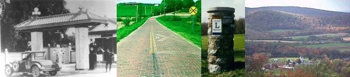
IN SEARCH OF . . .
THE DIXIE HIGHWAY IN OHIO
Page One
Michael G.
Buettner
February, 2006
By the fall of 1914, Carl G. Fisher was no longer at front and
center in the improvement activities of the Lincoln Highway
 Association.
Instead, much of his attention was being directed to the development of a
“jungle-like peninsula” of palmettos, mangroves, and marshes that we now know as
Miami Beach, Florida. The threat of war in Europe had helped to slow the sales
of lots, but Fisher was quick to recognize the ultimate need for a good road to
connect the cold industrial North to the warm tourist-friendly South.
Association.
Instead, much of his attention was being directed to the development of a
“jungle-like peninsula” of palmettos, mangroves, and marshes that we now know as
Miami Beach, Florida. The threat of war in Europe had helped to slow the sales
of lots, but Fisher was quick to recognize the ultimate need for a good road to
connect the cold industrial North to the warm tourist-friendly South.
In its original scope, the Dixie Highway was conceived by Carl Fisher as “a
great highway from Indianapolis to Miami.” Indianapolis was Fisher’s home town,
and he had begun wintering in Miami in 1910. With the help of W.S. Gilbreath of
the Hoosier Motor Club, Carl “made plans for a new road, mapping routes and
lining up participants” in much the same fashion as had been done for the
Lincoln Highway. It is not clear when the original northern terminus was revised
to Chicago, but in November 1914, Gilbreath was in Atlanta to attend the fourth
annual meeting of the American Road Congress, “trying to obtain approval from
the governors of all the states through which the highway…would pass.” He
promoted the newly proposed road as the Cotton Belt Route. With the optimistic
promise of new tourist dollars that in other times would have gone to a peaceful
Europe, he challenged the southern states to improve their deficient highway
networks, especially in the form of interstate highways.
By April 1915, the new north-south highway was being called the Dixie Highway.
According to one web site, the name was chosen “to honor fifty years of peace
between North and South.” At that time, Fisher and Gilbreath were part of a
conference in Chattanooga at which the Dixie Highway Association was formed.
This new association was modeled after the Lincoln Highway Association, and
there seems little question that Fisher’s experiences with that great east-west
transcontinental route proved valuable in this new endeavor. The Indianapolis
News reported that “every town in every state wished a place in the Dixie
Highway sun,” and some feared that the keen competition would kill the project
altogether. Fisher was reportedly quick to suggest a compromise idea at a May
meeting of the highway commissioners. Thus, instead of one highway, the
commissioners settled on two routes—a western route from Chicago to
Indianapolis, Louisville, and Nashville, which likely resembled Fisher’s
original idea; and an eastern route from Detroit to Cincinnati, Lexington, and
Knoxville. The routes had a junction point at Chattanooga.
From this concept of parallel highways funneling traffic south to Miami Beach,
the Dixie Highway system grew into a network of interwoven vines on a trellis of
eastern states. On the 1923 map, Asheville, North Carolina and Greenville, South
Carolina are waypoints on a later addition to the system. On that same map are
parallel Dixie Highway routes in the lower peninsula of Michigan which joined at
Mackinaw before reaching a northern endpoint at Sault Sainte Marie. There were
also multiple routes in Florida.
In Ohio, the selection of the first Dixie Highway route was accomplished over a
quick but colorful course of several weeks in 1915. To the benefit of this
writer, the Lima newspapers offered almost daily coverage of the planning
activities for the highway. With intentions to improve the proposed route in
Ohio, the Lake Loop District of the Dixie Highway was formed in Lima on June 4.
Representatives were present from nearly every city between Cincinnati and
Detroit.
Unfortunately, promoters in Lima soon found themselves in a difficult position,
with boosters in other nearby cities trying to align themselves on altered
versions of the first proposed route. From the start, Lima and Findlay had
worked together with Piqua, Sidney, Wapakoneta, and Bowling Green in seeking to
improve their part of the projected route, which already had a historical
precedent as
Main Market Route Number Seven. However, Ottawa and Napoleon fought
a spirited battle to sway the route away from Findlay and Bowling Green.
Likewise, the cities of Springfield, Urbana, Bellefontaine, and Kenton lobbied
for a Dixie Highway course that would pass through that line of county seats.
The local newspapers shuddered at the thought of Lima losing the route,
especially after being a lead player in the original plan. By August, the local
councils from Lima had finally restated their endorsement of a route which
paired their city with Findlay. In the end, the route that was originally
projected was the route that was chosen.
The importance of the Dixie Highway was not lost on the writer of one Lima
Daily News editorial. On July 29, 1915, he opined the following:
The Dixie Highway will be more valuable in one minute than the Lincoln Highway in one year, for the very reason that the resorters and persons planning trips up to Michigan will take the Dixie Road to reach their destinations. This will bring benefits to Lima business men, Lima hotels, and Lima in general. Get the highway, and let the other fellow fight about the route.
History would prove that writer to be somewhat correct. However,
in modern times, most vacationers are now heading south, while it is the many
hunters and fishers that still head north. Regarding traffic, today’s version of
the Dixie Highway is essentially the crowded route of Interstate 75, which
carries five times the traffic as U.S. Route 30, the modern equivalent of the
Lincoln Highway.
In an earlier editorial published in the May 16, 1915 issue of The Lima
Sunday News, the existing Lincoln Highway was seen as a potential
beneficiary of the Dixie Highway. As it was written:
Lima should be on [the Dixie Highway], if for no other reason than the fact that it will be a junction point with the Lincoln Highway. This would ensure the coming of tourists who would be seeking a trip out of Chicago, yet would prefer to come through a new territory in reaching eastern points…While the Lincoln Highway has not been the wonderful success that originally was expected…the Dixie Highway should go a long way toward solving the problem…[putting] the Lincoln Highway on the map more forcibly than by any other means.
Lima would in fact become the original point of intersection for
the Lincoln Highway and the eastern branch of the Dixie Highway. The 1920
Automobile Blue Book states that a monument was located in the Lima Public
Square to recognize this fact, but this author has never found any photographic
evidence to support this statement. Alas, the relocation of the Lincoln Highway
in June 1919 to the long straight course through Beaverdam would have rendered
the memorial a moot point.
In tracing the route of the Dixie Highway through Ohio, I have relied on a
combination of three guide books from the 1920s, plus numerous official Ohio
Department of Highways (ODH is now known as ODOT) maps. The Ohio Department of
Transportation has scanned over
ninety years of official highway maps and has posted them on their web site.
Thus, knowing the locations of State Route 6 (between 1923 and 1926) and U.S.
Route 25 (after 1926) makes it much easier to trace the routes of the Dixie
Highway in Ohio.
Beginning at the Michigan border, there have been two popular routes between
Detroit and Toledo, witnessed by the closely parallel routes of U.S. 24
(Telegraph Road) and U.S. 25 (Detroit Avenue) for many years. Once upon a time,
the federal routes actually overlapped on Detroit Avenue in Toledo, but today
only U.S. 24 is marked, while the U.S. 25 designation was dropped in deference
to Interstate Route 75. The Dixie Highway would have reached downtown Toledo by
way of 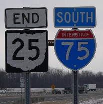 Collingwood Avenue and Jefferson Avenue (one guide has Madison Avenue)
before turning southwest at St. Clair Street. Modern travelers will now have to
follow Summit Street out of downtown, because St. Clair Street is no longer a
through street.
Collingwood Avenue and Jefferson Avenue (one guide has Madison Avenue)
before turning southwest at St. Clair Street. Modern travelers will now have to
follow Summit Street out of downtown, because St. Clair Street is no longer a
through street.
Only 34 miles of today’s State Route 25 remain
in northwest Ohio to continue the legacy of that once important federal highway
number. The southbound terminus of the route is partway down the entrance ramp
of the I-75 interchange at Cygnet.
Leaving downtown Toledo, the earliest guide books chart a preferred route which
crossed the Maumee River at the old Fassett Street Bridge, which disappeared
from the highway maps after 1959. In 1923, this would become the path of State
Route 6, passing through Rossford before turning south at Perrysburg. On the
1926 map, a tentative U.S. 25 shield is shown on this same alignment. However,
subsequent maps indicate that U.S. 25 was moved to the north side of the river,
following Broadway Street out of Toledo and into Maumee—crossing the river at
the historic bridge at the south end of Conant Street. The Dixie Highway route
through Rossford was then renumbered as a part of U.S. 23. By the 1940s, the
route of U.S. 25 would completely avoid downtown Toledo with an alignment that
followed the newly constructed Anthony Wayne Trail easterly from Maumee to an
intersection with Detroit Avenue, where it turned north for several miles to
meet the previous alignment.
To reach the Rossford side of the river, turn left from Summit Street to cross
the Anthony Wayne Suspension Bridge, which hosts State Route 2, State Route 51,
and State Route 65. Follow the signs of State Route 65 out of the Toledo city
limits, by way of Oak Street, Fassett Street, and Miami Street to meet the
original alignment. In downtown Rossford, State Route 65 curiously becomes
either Dixie Highway (southbound) or Superior Street (northbound), depending on
which side of the boulevard one is traveling. Between Rossford and Perrysburg,
the route is marked as Dixie Highway, then River Road.
In Perrysburg—a historic and photogenic town that is worth a day trip all by
itself—the old route follows Front Street into downtown, then turns south for
three blocks on Louisiana Avenue (diverging from State Route 65), west for two
blocks on Indiana Avenue, and south again on Findlay Street, which will
eventually merge into State Route 25. In Wood County, the numbered route is also
marked as Dixie Highway and can easily be followed to Bowling Green. Several
establishments along the route make use of the Dixie name, including one
old-fashioned motel court just south of the I-475 Bypass.
One mile east of downtown Perrysburg, and along the north side of U.S. 20
(Sandusky Street), is Milestone Park, which features milepost one of the old
Maumee and Western Reserve Road. This historic road was laid out in the 1820s to
cross the swamplands between Perrysburg and Lower Sandusky, which is now named
Fremont. West of town is the site of Fort Meigs, where the British were turned
back in the War of 1812. This site was recently expanded by the Ohio Historical
Society to include a large welcome center.
One of my favorite stops whenever I travel this route is the Wood County
Courthouse in Bowling Green, completed in 1896. Perrysburg, which is one of only
four Ohio towns surveyed by the national government, had been the first county
seat, but as the county grew, the government offices were moved to this more
central location. The beautiful courthouse interior is enhanced by two large
murals which recall two eras of history—one is a tribute to Fort Meigs, and the
other recalls the fascinating era of oil drilling which boomed the area in the
late 1800s.
South of Bowling Green, State Route 25 becomes an example of four-lane
redundancy rendered by the completion of an adjacent portion of Interstate 75 in
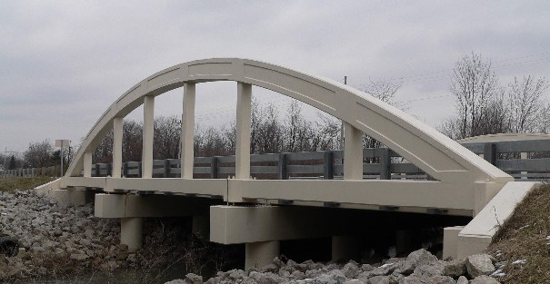
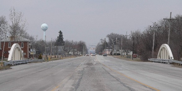
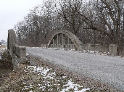
the late 1960s. Especially interesting is the presence of concrete arch replicas
at two new bridges which now span all four lanes of the divided highway. These
bridges are recent replacements for two unmatched pairs of old bridges in both
the original northbound and later-built southbound lanes. The concrete arches
are modeled after similar Marsh rainbow arches that were constructed in the
1920s on the original two lane alignment.
| (click to enlarge) These Marsh rainbow concrete arches are merely decorations for the new four-lane bridge on Dixie Highway/State Route 25 south of Portage. However, they are reminders of the previous 1920s bridge which had been on the original two lane highway. When U.S. 25 became a divided highway, the original concrete arch bridge served the northbound lanes. A second similar bridge is one mile south of here. An original bridge is on Insley Road three miles south of the I-75 interchange at Cygnet. | |
 |
 |
|
Looking east from the west side of the road. |
Looking north from the middle of the road. |
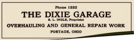 Right. Based on an advertisement in the 1922
Automobile Green Book, the town of Portage was also home to the Dixie Garage.
Right. Based on an advertisement in the 1922
Automobile Green Book, the town of Portage was also home to the Dixie Garage.
A third concrete arch bridge, in original form, can be found about three miles
south of the Cygnet interchange (I-75 Exit 171). To reach this bridge—plus a
rare snippet of antique roadway—follow the service road now marked as Insley
Road along the west right-of-way fence of Interstate 75. From the Cygnet
interchange, the service road can be reached by following State Route 25 a short
distance down the southbound ramp toward the four-lane highway, and then turning
right where the numbered route abruptly ends. In this few miles, the interstate
highway was actually built on top of a revised two-lane version of U.S. 25 that
was opened in the 1930s to eliminate sharp curves in the original
 road—such as
those on the undisturbed parts of Insley Road. Thus, despite its age, this
particular bridge had an unusually short lifetime on the federal route. Beyond
the old bridge, it is not hard to imagine the old road blending into the present
alignment.
road—such as
those on the undisturbed parts of Insley Road. Thus, despite its age, this
particular bridge had an unusually short lifetime on the federal route. Beyond
the old bridge, it is not hard to imagine the old road blending into the present
alignment.
(click) This original Marsh rainbow concrete
arch bridge built in the 1920s is three miles south of the I-75 interchange at
Cygnet, on a remnant of the Dixie Highway now marked as Insley Road.
Just south of Quarry Road, travelers should merge into Interstate 75 at an odd
interchange (because it has no bridges), but only long enough to cross over the
busy double-tracked mainline of the old Baltimore and Ohio Railroad. Then, after
leaving the four-lane freeway at Exit 167, turn east (left) on State Route 18
toward the opposite side of the interstate, watching for another service road
along the east right-of-way fence of the highway. At a point opposite
McDonald’s, turn south (right) onto Wood County Road 588—which will become
Hancock County Road 220 after just one-half mile—and resume with a two-lane
alignment of the old Dixie Highway.
Hancock County uses road numbers and not road names outside of incorporated
areas, so the Dixie Highway name is temporarily suspended here in favor of the
County Road 220 designation. The road runs due south through the village of Van
Buren on a township line that was set off by surveyors in 1820, at sixty miles
from the Indiana border. In the early stages of the War of 1812, General William
Hull had marched over 2200 soldiers north though this same general corridor,
only to controversially surrender to a smaller British force at Detroit.
In Findlay, the historic routes of the Dixie Highway and U.S. 25 pass through a
still-vibrant downtown on Main Street. The office building of the Marathon Oil
Company dominates the city skyline. In the south part of town, the routes turn
southwest toward Lima on Lima Street and Lima Avenue, appropriately. Like
Bowling Green, Findlay’s demographics are enhanced by the presence of a
university which bears the city’s name, and impressive new facilities are
evident on the north side of town. The opulent Hancock County Courthouse in
downtown Findlay—completed in 1888 on the heels of a prosperous gas
boom—features several impressive works of stained glass (each piece beveled)
that are unsurpassed by any in the state, and is always worth a visit. A bronze
statue of John Hancock, for whom the county is named, overlooks the city.
Beyond Findlay, the routes of the Dixie Highway and U.S. 25 cut a remarkably
straight diagonal all the way to way to Lima, with only a brief change of
direction at a sweeping reverse curve northeast of Bluffton. In Hancock County,
the highway is signed as County Road 313, but the Dixie Highway name is revived
beyond Bluffton in Allen County. This is still a pleasant drive that I often
make today, if only to relax and to avoid the aggressive traffic on the
interstate. In Bluffton—as in many other towns to be visited on this tour—the
route of the Dixie Highway is on Main Street. Much of the community’s culture
fronts on this neatly-kept street that is always colorfully decorated with
American flags. Another namesake university is also an integral part of the
community.
Three miles southwest of Bluffton, the diagonal Dixie Highway crosses a railroad
at a common point with the north-south Phillips Road, which was laid out on the
section lines. This location is locally known as Gratz Crossing (named for an
adjacent landowner), and improvements made here in 1934 were intended to improve
a notoriously dangerous grade crossing, while also eliminating four turns. Prior
to the construction of the surviving superelevated reverse curve, there was no
diagonal road between Hillville Road and Phillips Road. Unfortunately, just
beyond the end of the curve, the original Dixie Highway is again obliterated by
the construction of Interstate 75, and can not be recovered again as a two-lane
road until just northeast of Beaverdam. By taking Hillville Road one mile west,
then turning south (left) on Swaney Road for another mile, the route of the
original Dixie Highway can be picked up again and followed into Beaverdam.
At Beaverdam, the Mid-Ohio Chapter of today’s Lincoln Highway Association has
erected a brick pillar replica on the original concrete base of a similar
previous marker. The fate of the first pillar is unknown, but any driver who
failed to stop at the Main Street intersection could have smacked into the
original bricks (please do not let that happen again). At the replica marker, a
new plaque of dedication appropriately commemorates Carl Fisher, founder of both
the Lincoln Highway and Dixie Highway. Beginning in 1919, several blocks of
Beaverdam’s Main Street have been shared by the traditional paths of the two
great transcontinental highways.
Today it captures the imagination to picture the interesting strip of tourist
services that would have once existed here. Included among them would have been
the Dixie-Lincoln Restaurant, which is believed to have had three different
locations, and the Parks-Klay Service Center, an easily-recognized building
which is still the site of a local grocery. It is almost laughable to compare
these modest services to the huge truck plazas at the nearby I-75 interchange,
but they would have more than adequately served their purpose in their day.
Southwest of Beaverdam, the diagonal course of the Dixie Highway is twice
obliterated by modern four-lane highways. The original route is reached again by
turning south (left) from Main Street at the only flashing signal in downtown
Beaverdam, onto West Street/Napoleon Road. After passing over Interstate 75 and
under U.S. 30, immediately turn west (right) onto a service road marked as Dixie
Highway. Eventually, the road will angle southwest and resume with the original
alignment toward Lima. In a most unusual engineering design, several residences
are on an isolated remnant of the old highway that is virtually trapped between
the two four-lane freeways—accessible only by way of an expanded exit ramp.
The Dixie Highway does not change direction again until reaching a recently
improved intersection with State Route 81 east of Lima. Enter Lima by following
State Route 81 into the downtown, bearing west on Findlay Road, south on
Jefferson Street, and west on North Street—passing beneath another line of the
old Baltimore and Ohio Railroad. At the fourth traffic signal past the Allen
County Courthouse, resume south toward Wapakoneta with a left turn onto Metcalf
Street. A fine old cottage-style Pure Oil station is now disguised as a doughnut
shop on the southeast corner of this intersection. The Allen County Museum, on
the west side of Metcalf Street in the block between High Street and Market
Street, is one of the best county museums anywhere, and has a children’s garden
with a Lincoln Highway interpretive site. (book
a hotel in Lima)
The above instructions match the 1927 route of U.S. 25 through Lima. As
mentioned in the early part of the article, the original Dixie Highway would
have passed through the Public Square on Main Street, intersecting the early
route of the Lincoln Highway at Market Street. In later years, the numbered
route would have passed under the old Pennsylvania Railroad by way of Union
Street and Pearl Street, and not under the old Baltimore and Ohio Railroad as
charted above. The latter underpass, designed by the firm for which this writer
is employed, was opened in the late 1980s to improve traffic flow through the
city.