|
|
SECTION 2—LISBON TO MINERVA—20.0 MILES
Between Lisbon and Minerva, the route of the 1928 Lincoln Highway
begins its transition from an "eastern" road to a "western" road. For
the first time on its transcontinental journey, the highway traces the
lines of the rectangular survey system, although none of these
"straight" east-west courses are as long as two miles. There were no
such squared lines in New Jersey and Pennsylvania, where the location
of the route was controlled by the historic paths of colonial
highways, and then by the topography of the Appalachian Mountains and
the Ohio River. Even in the area between East Liverpool and
Lisbon—where the rectangular surveys commenced—the prominent hills and
hollows continued to control the location of the route, with no regard
for the survey lines.
Lisbon is the seat of government for Columbiana County, which also
includes East Liverpool and Hanoverton, and is blessed with many fine
old buildings. The town was founded as New Lisbon in 1803—the year of
Ohio's statehood—and after Marietta, is the second oldest town in the
state. Lisbon has an impressive list of sixty homes and buildings on
the Ohio Historic Inventory, with over twenty of these homes on the
street now known as Lincoln Way.
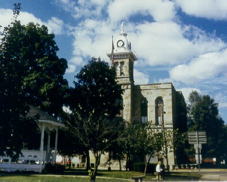
 The Columbiana County Court House
is in Lisbon, the second oldest city in Ohio. Built in 1870, the
building was remodeled in 1933 using large blocks of stone salvaged
from the old locks of the failed Sandy and Beaver Canal. The Columbiana County Court House
is in Lisbon, the second oldest city in Ohio. Built in 1870, the
building was remodeled in 1933 using large blocks of stone salvaged
from the old locks of the failed Sandy and Beaver Canal.
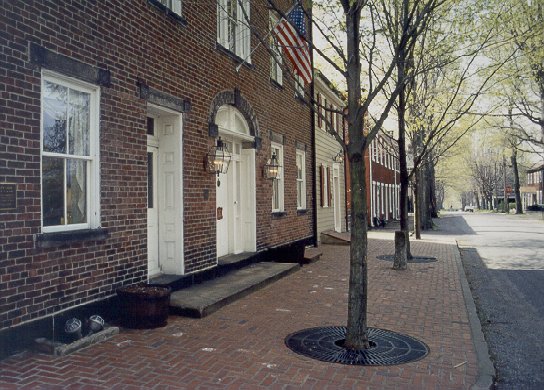
Hanoverton also has many fine old buildings, especially on Historic
Plymouth Street, which intersects the Lincoln Highway one block east
of the main intersection in town. These buildings are all in a
community that is reminiscent of a small town in New England, and the
short drive up this street is definitely a worthwhile departure from
the charted course. The highlight on Plymouth Street is the
wonderfully restored Spread Eagle Tavern, which has become a popular
destination for modern-day members of the Lincoln Highway Association.
Several other buildings are also of historical and architectural
interest, including one building that was a stop on the Underground
Railroad. Thankfully, all these buildings survived a terrible fire in
October 1918 which destroyed the center of town.
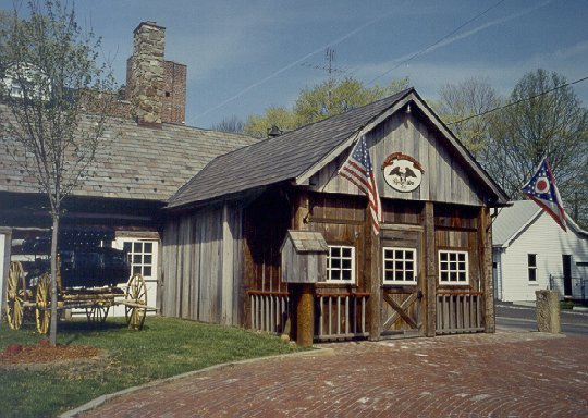
 The wonderfully-restored Spread
Eagle Tavern is the highlight on Historic Plymouth Street (below) in
Hanoverton, a small town that brings New England to mind. The history
of the tavern dates back to 1837, just before the coming of the canal
and the town's heyday. The wonderfully-restored Spread
Eagle Tavern is the highlight on Historic Plymouth Street (below) in
Hanoverton, a small town that brings New England to mind. The history
of the tavern dates back to 1837, just before the coming of the canal
and the town's heyday.
 The Spread Eagle Tavern was the host for the sixth
annual meeting of the Ohio Lincoln Highway League. A highlight of the
day's events was the setting of the fourth concrete post replica in
Ohio, at the intersection of Plymouth Street and the old Lincoln
Highway. A brick pillar replica has also been built at the
intersection in the center of town. The Spread Eagle Tavern was the host for the sixth
annual meeting of the Ohio Lincoln Highway League. A highlight of the
day's events was the setting of the fourth concrete post replica in
Ohio, at the intersection of Plymouth Street and the old Lincoln
Highway. A brick pillar replica has also been built at the
intersection in the center of town.
Gradually leaving the Appalachian foothills, the route beyond
Hanoverton, and between Kensington and Minerva, is the flattest
section of the Lincoln Highway in the eastern two-thirds of the state.
Here, the highway parallels Sandy Creek for about ten miles, dropping
only 60 feet over that distance. This corridor was long ago followed
by the Sandy and Beaver Canal, which was a short-lived endeavor to
connect what is now Lisbon with other commercial markets. Also
constructed in this corridor was the Cleveland and Pittsburgh
Railroad, which later became part of the Pennsylvania Railroad. Both
the small towns of Kensington and East Rochester grew up as stations
on this railroad.
The Sandy and Beaver Canal was completed in 1848, but ceased
operations in 1852, "when a reservoir burst and finances collapsed, in
part because of the competition from the railroads." The canal system
included 90 locks, 30 dams, and two tunnels cut through solid
stone—including the longest canal tunnel in the United States.
According to the local brochures, much of the canal channel and
several locks can still be observed today. A historical marker for the
canal tunnels is on the south side of the highway about one mile east
of Hanoverton.
Through Hanoverton, the Sandy and Beaver Canal followed the course of
Sandy Creek. What is now Lincoln Street is probably part of the
towpath of the old canal. West of town, remnants of the channel can be
observed on the north side of U.S. 30. Beyond Kensington, the old
channel remains with Sandy Creek, but is on the south side of the
highway.
An interesting bit of local lore concerns the fate of some of the lock
stones from the canal. Large blocks of stone salvaged from the old
locks were used in the 1933 remodeling project at the Columbiana Court
House. Then in 1947, another large block of stone was used to complete
the remodeling of the entrance of a Lisbon church. These were
honorable ways for the failed canal to repay part of its debt to the
community.
With respect to early roads and highways, the route of the Lincoln
Highway between Lisbon and Minerva follows one of the original routes
of the Ohio Inter-County Highway System. This particular route was
designated as Inter-County Highway #368, or Lisbon-Canton-Southern
Road. It was also part of Main Market Route No. 3, and later assumed
the typical designations as State Route 5 and U.S. 30.
Since 1928, the alignment of this route appears to have undergone few
major changes. When U.S.Route 30 was first designated between Lisbon
and Minerva, it appears to have followed completely the route of I.C.H.
#368. The most significant change since that time is a 1.5-mile
stretch, constructed in the late 1950s, which begins about four miles
west of Lisbon, and ends just past the structure over the West Fork of
Little Beaver Creek. An old curving piece of the early roadway, shown
on the Columbiana County map as Old Thirty Road, remains southeast of
the present structure, and can be reached by way of the north end of
what is now Trinity Church Road, which also had been part of the
earlier alignment. However, tourists are advised to observe this
particular remnant without leaving Trinity Church Road, because "Do
Not Enter" and "Private/Keep Out" signs have been posted here.
Aside from this realignment, the usual improvements of curves and
grades would probably be expected over the course of time. There are
presently no four-lane sections between the endpoint towns of this
route. However, the Ohio Department of Transportation (ODOT) is
studying several corridors in this area for the planning of a future
four-lane version of U.S. Route 30 which would connect with existing
State Route 11 near Lisbon.
Except for a short diversion in Hanoverton, the charted course for
this section between Lisbon and Minerva is the same as the route of
U.S. 30. This diversion in Hanoverton includes using the First Street
bridge to cross Sandy Creek, and Lincoln Street on the south side of
the creek, to correctly follow the 1928 route marked by the Boy
Scouts. The present Canal Street/U.S. 30 bridge over Sandy Creek was
built some time later, and eliminated the two turns at First Street.

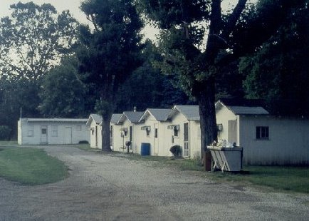
These cabins in Minerva are at the location of the
old Green Gables Tourist Court.
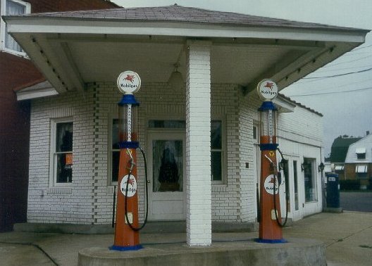
Minerva is the largest town between East Liverpool and Canton, and the
control station selected here for the odometer charts is the site of
an old gas station on the southwest corner of Market Street and
Lincoln Way, which predates the transcontinental route by a couple
years or so. This is one of only a few old-fashioned corner buildings
which have survived along the route in Ohio. The property is now part
of a gift shop, and provides a nice gateway to one of the prettiest
little downtown areas in the state. In 1998, an original concrete post
was found by three boys in a wooded area near Robertsville, and was
placed near the southeast corner of this intersection.
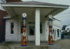 This old gas station in Minerva dates back to about
1910. This old gas station in Minerva dates back to about
1910.
Odometer
charts for this section
Strip Maps for this section
|