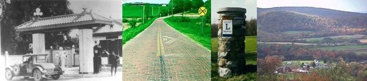
Images From The National Road
By Michael G. Buettner
Ohio's Madonna of the Trail statue is on the west side of
Springfield, regrettably inaccessible by auto from
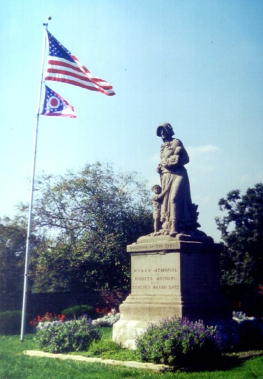 today's U.S. 40.
I had to leave my car in a park on the opposite side of a creek, then ramble
across the highway bridge and two guardrails, in order to take this photo.
According to The National Road by Karl Raitz, there are twelve duplicate
Madonnas along the route of U.S. 40, including at least three others on the old
National Road—in Beallsville, Pennsylvania; Wheeling, West Virginia; and
Vandalia, Illinois. The statues stand as "the culmination of the Daughters of
the American Revolution's efforts to commemorate National Road history." Indeed,
the image of the frontier mother, with an infant in her arms and a small boy
clinging to her side, is a fine and fitting tribute.
today's U.S. 40.
I had to leave my car in a park on the opposite side of a creek, then ramble
across the highway bridge and two guardrails, in order to take this photo.
According to The National Road by Karl Raitz, there are twelve duplicate
Madonnas along the route of U.S. 40, including at least three others on the old
National Road—in Beallsville, Pennsylvania; Wheeling, West Virginia; and
Vandalia, Illinois. The statues stand as "the culmination of the Daughters of
the American Revolution's efforts to commemorate National Road history." Indeed,
the image of the frontier mother, with an infant in her arms and a small boy
clinging to her side, is a fine and fitting tribute.
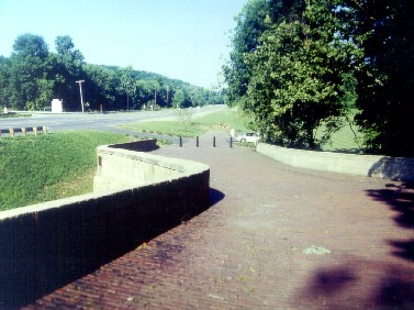
 Funded with
ISTEA (Intermodal Surface Transportation Efficiency Act) money through ODOT
(Ohio Department of Transportation) this 1830 S-bridge on the west side of New
Concord has been wonderfully restored. Other preservation activities are certain
to take place as the Ohio Historic Preservation Office completes surveys of
historic properties and inventories of significant landmarks.
Funded with
ISTEA (Intermodal Surface Transportation Efficiency Act) money through ODOT
(Ohio Department of Transportation) this 1830 S-bridge on the west side of New
Concord has been wonderfully restored. Other preservation activities are certain
to take place as the Ohio Historic Preservation Office completes surveys of
historic properties and inventories of significant landmarks.
Although colorful legends abound which attempt to explain the
unique S-bridges, there is little question that the structures simply provided
the shortest path across the stream, thus requiring the least amount of
materials. Only the middle portion of the bridge is actually arching over the
creek, with the end portions serving as walls holding the fill for the
approaches.
—sources: The National Road, by Karl Raitz
U.S. 40 Today, by Thomas R. Vale and Geraldine R. Vale
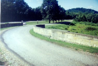
 Another
S-bridge can be found four miles west of downtown Cambridge, at the settlement
of Cassell. This structure crosses Peters Creek with geometry and materials very
much like the S-bridge at New Concord. It will be interesting to watch this site
in upcoming years to see if preservation work will be done to the extent of the
New Concord bridge.
Another
S-bridge can be found four miles west of downtown Cambridge, at the settlement
of Cassell. This structure crosses Peters Creek with geometry and materials very
much like the S-bridge at New Concord. It will be interesting to watch this site
in upcoming years to see if preservation work will be done to the extent of the
New Concord bridge.
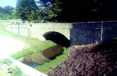
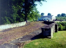
 Located on
what is now marked Bridgewater Road in Guernsey County, this structure over Salt
Fork is the largest of Ohio's S-bridges. The best way to reach this site is to
leave Interstate 70 at the State Route 513 interchange, also known as Exit 173.
Bridgewater Road parallels the interstate on the north side, and the S-bridge is
3 miles west of State Route 513. The skewed crossing of Salt Fork contributes to
the extra length of this photogenic cut stone bridge.
Located on
what is now marked Bridgewater Road in Guernsey County, this structure over Salt
Fork is the largest of Ohio's S-bridges. The best way to reach this site is to
leave Interstate 70 at the State Route 513 interchange, also known as Exit 173.
Bridgewater Road parallels the interstate on the north side, and the S-bridge is
3 miles west of State Route 513. The skewed crossing of Salt Fork contributes to
the extra length of this photogenic cut stone bridge.
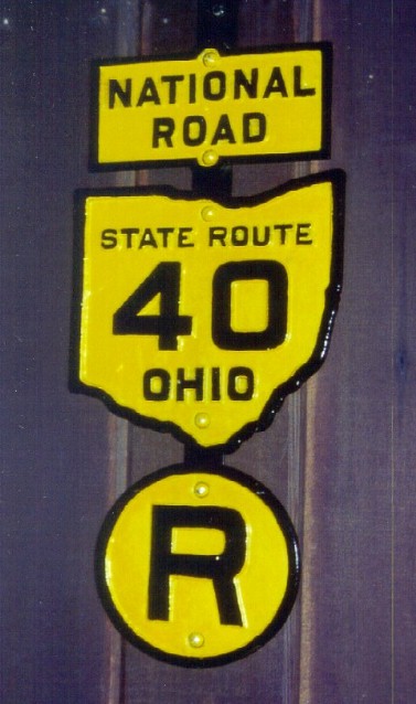 Although
historically imperfect, this assembly of signs at the National Road/Zane Grey
Museum near Norwich is nonetheless an excellent example of Ohio's earliest
highway markings for named and numbered highways. The National Road was actually
State Route 1 from 1923 to 1926, then became U.S. Route 40 when the federal
routes were first marked. It was never designated as State Route 40, which was
instead a nearby route from Zanesville to Washington Court House that became
U.S. Route 22. The R at the bottom of the sign assembly would have indicated
that the route turned right not far ahead.
Although
historically imperfect, this assembly of signs at the National Road/Zane Grey
Museum near Norwich is nonetheless an excellent example of Ohio's earliest
highway markings for named and numbered highways. The National Road was actually
State Route 1 from 1923 to 1926, then became U.S. Route 40 when the federal
routes were first marked. It was never designated as State Route 40, which was
instead a nearby route from Zanesville to Washington Court House that became
U.S. Route 22. The R at the bottom of the sign assembly would have indicated
that the route turned right not far ahead.
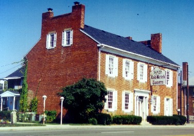 The Red
Brick Tavern is located about 20 miles west of Columbus in the crossroads
community of Lafayette. Built in 1837 and said to be the second oldest in the
state, the tavern "enjoyed prosperity during the heyday of travel on the
National Road." Six presidents dined here, including five who served in the
early 1800s, a period during which the National Road was the chosen path across
Ohio. The tavern closed during the railroad era but reopened to welcome
automobile travelers. One of the oldest National Road mileposts stands in the
yard—one of only three between Columbus and Springfield.
The Red
Brick Tavern is located about 20 miles west of Columbus in the crossroads
community of Lafayette. Built in 1837 and said to be the second oldest in the
state, the tavern "enjoyed prosperity during the heyday of travel on the
National Road." Six presidents dined here, including five who served in the
early 1800s, a period during which the National Road was the chosen path across
Ohio. The tavern closed during the railroad era but reopened to welcome
automobile travelers. One of the oldest National Road mileposts stands in the
yard—one of only three between Columbus and Springfield.
—source: The National Road, by Karl Raitz
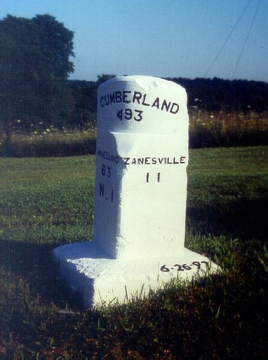 As
indicated by the numbers, this National Road milepost is 193 miles [west] from
the road's terminus at Cumberland, Maryland and eleven miles [east] from
Zanesville. Over a dozen mileposts can be found on the north side of the
historic road between Columbus and Cambridge (by comparison, only three can be
found between Columbus and Springfield). Most of the posts now along the road
appear to be reproductions from various eras. The best original posts are now
preserved at the National Road/Zane Grey Museum near Norwich, at Exit 164 of
Interstate 70.
As
indicated by the numbers, this National Road milepost is 193 miles [west] from
the road's terminus at Cumberland, Maryland and eleven miles [east] from
Zanesville. Over a dozen mileposts can be found on the north side of the
historic road between Columbus and Cambridge (by comparison, only three can be
found between Columbus and Springfield). Most of the posts now along the road
appear to be reproductions from various eras. The best original posts are now
preserved at the National Road/Zane Grey Museum near Norwich, at Exit 164 of
Interstate 70.
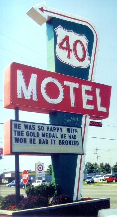 This wonderful
sign along the contemporary National Road is in the neighborhood of West
Columbus, about one mile east of the Interstate 270 bypass. The motel itself
appears to date from that era of highway architecture that immediately precedes
the original Holiday Inns and Howard Johnsons of the 1950s. From this point
west, the National Road runs straight toward the setting sun to Indianapolis,
before veering slightly south of west toward its terminus at the original
Illinois capital in Vandalia. Thus, the National Road at one time connected
three midwestern capitals. In Columbus, the historic route followed what is now
Main Street into town from the east, jogged north toward the State House on High
Street, and turned west onto Broad Street.
This wonderful
sign along the contemporary National Road is in the neighborhood of West
Columbus, about one mile east of the Interstate 270 bypass. The motel itself
appears to date from that era of highway architecture that immediately precedes
the original Holiday Inns and Howard Johnsons of the 1950s. From this point
west, the National Road runs straight toward the setting sun to Indianapolis,
before veering slightly south of west toward its terminus at the original
Illinois capital in Vandalia. Thus, the National Road at one time connected
three midwestern capitals. In Columbus, the historic route followed what is now
Main Street into town from the east, jogged north toward the State House on High
Street, and turned west onto Broad Street.