The Lincoln Highway Near Canton
By Jim Ross
Beautiful brick alignments of the Lincoln Highway, such as the one pictured
above left, still exist east of Canton, Ohio. Originally paved in about 1919
-20, many sections of road were abandoned within 20 years because of the rough
terrain on which the original road was laid. The section this article will
concentrate is the 11 mile Minerva to East Canton stretch.
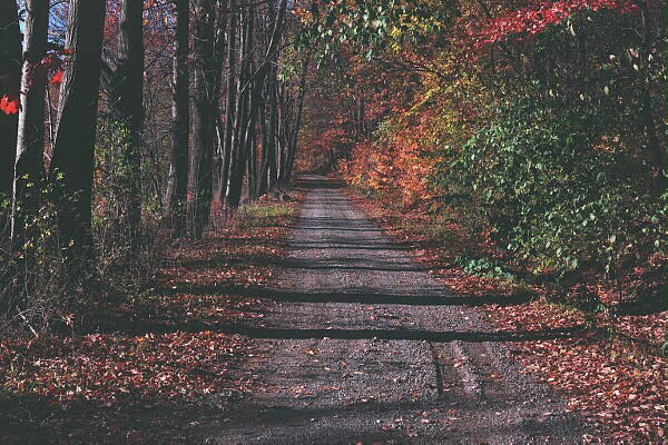
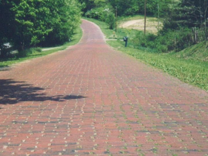 This
is part of the Baywood section just southeast of Roberstville. It is a stretch
just under 3 miles long, and about half of it still has exposed brick.
(click to enlarge)
This
is part of the Baywood section just southeast of Roberstville. It is a stretch
just under 3 miles long, and about half of it still has exposed brick.
(click to enlarge)
When the Lincoln Highway Association announced on September 1, 1913 that the
route would run from Times Square in New York to Lincoln Park in San Francisco,
cities and states along the proposed route were ecstatic for the recognition and
commerce about to come their way. Those not on the route continued to fight for
inclusion.
One battle for inclusion on the route was fought between the residents of
northern and southern Paris Township in southeast Stark County. The northern
residents of the township, and civic leaders from nearby towns such as Alliance,
campaigned to change the planned route to follow what is now Route 172 through
New Franklin and Paris. They pointed out that the road was wider, straighter,
and better maintained than the proposed route to the south, Minerva to East
Canton. The Lincoln Highway Association was not swayed, and the Association's
president, Frank Seiberling of Akron, pointed out that there was considerable
pressure on him from his town to move the highway even further north through
Summit County.
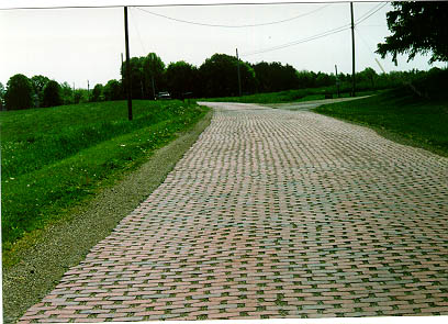
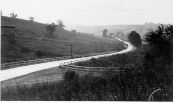 The picture on
the right was taken on the Robertsville to East Canton stretch. Lincoln Highway
Collection, Transportation History Collection, Special Collections Library,
University of Michigan. An interesting comparison of today's (still brick)
road can be found in our Then and Now section
The picture on
the right was taken on the Robertsville to East Canton stretch. Lincoln Highway
Collection, Transportation History Collection, Special Collections Library,
University of Michigan. An interesting comparison of today's (still brick)
road can be found in our Then and Now section
The Lincoln Highway was built with private and local funds because the Federal
Government was not yet convinced of the value of such roads; rail was still the
way to move people and freight over long distances. But those who had something
to gain from such a route, such as Sieberling, founder of Goodyear Tire, and
Henry B. Joy of Packard Motor Car Company donated large sums of money. It is
interesting to note that Henry Ford was not interested in the highway despite
the urging of friends Sieberling, Joy, and Thomas Edison.
 The
Lincoln Highway entered Stark County on what is now known as US 30 in Minerva.
It continued west to Robertsville, Baywood Section East Canton and Canton on or
near what is now known as Lincoln Street. Once inside Canton, it continued on
toward Massillon on Tuscarawas Street, entering Massillon as Lincoln Way, and
leaving the county near East Greenville as Lincoln Way again.
The
Lincoln Highway entered Stark County on what is now known as US 30 in Minerva.
It continued west to Robertsville, Baywood Section East Canton and Canton on or
near what is now known as Lincoln Street. Once inside Canton, it continued on
toward Massillon on Tuscarawas Street, entering Massillon as Lincoln Way, and
leaving the county near East Greenville as Lincoln Way again.
One of the most interesting sections of the old Lincoln Highway in the United
States is the section between
 Minerva
and East Canton. Most of the road we use today to travel between the two towns
was not a part of the original Lincoln Highway. The original route in this
section was a narrow twisting road built on farm lanes over hills and sometimes
through woods. Parts of the 1913 dirt alignment, and the 1919 brick improvement
can be found today.
Minerva
and East Canton. Most of the road we use today to travel between the two towns
was not a part of the original Lincoln Highway. The original route in this
section was a narrow twisting road built on farm lanes over hills and sometimes
through woods. Parts of the 1913 dirt alignment, and the 1919 brick improvement
can be found today.
In retrospect, those who called the Minerva to East Canton route inferior to the
New Franklin to East Canton proposal were correct. By 1917, the Lincoln Highway
in Ohio had 72 miles of brick pavement, 166 miles of other hard surfaces, and 18
miles of dirt. At least three miles of that dirt was in this section.
The original Minerva to East Canton leg was used from about 1913 to about 1940,
but as cars became bigger
 and
faster, the width and tight turns of the road became intolerable. Attempts were
made in places to uproot the brick and spread them further apart to widen the
road; but even this wasn't enough, and a whole new road was constructed with
Federal funds between the two villages. With the construction of the new road,
much of the original highway was relegated to residential street status, leaving
us years later with several antique stretches of road.
and
faster, the width and tight turns of the road became intolerable. Attempts were
made in places to uproot the brick and spread them further apart to widen the
road; but even this wasn't enough, and a whole new road was constructed with
Federal funds between the two villages. With the construction of the new road,
much of the original highway was relegated to residential street status, leaving
us years later with several antique stretches of road.
By 1928, most of the Lincoln Highway was paved the length of the continent, and
on September 1 of that year,
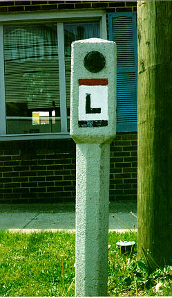 the
Boy Scouts of America marked the entire route with concrete highway posts about
a mile apart. The state of Ohio had 241 of these markers, and only three of them
can still be found at or near their original locations. One of the original
markers is in East Canton on the south side of Nassau Street one half block west
of Cedar Street. Another Stark County marker is in Minerva on the southeast
corner of Lincoln Way and Market Street, however, it's original location is not
known. Marker in East Canton
the
Boy Scouts of America marked the entire route with concrete highway posts about
a mile apart. The state of Ohio had 241 of these markers, and only three of them
can still be found at or near their original locations. One of the original
markers is in East Canton on the south side of Nassau Street one half block west
of Cedar Street. Another Stark County marker is in Minerva on the southeast
corner of Lincoln Way and Market Street, however, it's original location is not
known. Marker in East Canton
An afternoon exploring the road between East Canton and Minerva is worth the
time for the historical minded, but it should be remembered that parts of the
road are on private property and should not be trespassed, and starting and
stopping on a busy highway such as this could be dangerous. A good tour of this
section might begin at the mile marker in East Canton and end with a visit at
the mile marker in Minerva.
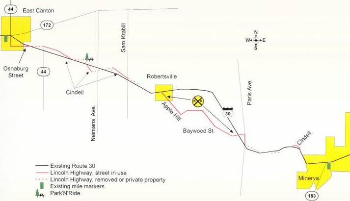
There are two 'must see' sections of the highway for road enthusiasts. The first
is a section of Cindell Street. Cindell It is just west of Sam Krabill Avenue
and is still brick. The original road east of Sam Krabill is on private
property.
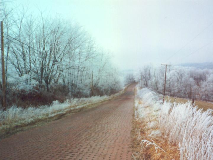
Photo by Jerry Smith of Robertsville, Ohio
A more impressive section begins in Robertsville near the center of the town on
Applehill Avenue. Follow this road south from the main highway to see what
Michael Buettner (author of A History and Road Guide of the Lincoln Highway
in Ohio, calls "perhaps the best remnant in Ohio." Applehill turns into Baywood
Street and comes to the highest part of this highway in Stark County. From this
ridge road you will be traveling a brick road with some of the best views in the
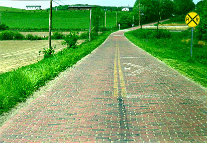
area. The road descends the hill crossing railroad tracks at the bottom. Note
that the brick at the bottom of the hill is still painted with dividing lines
and rail crossing warnings. Rail Crossing.
 The picture to the right remains the favorite of the author. It
was used in "Ford Restorer" in April 2001 and several advertisements in Ohio
Magazine.
The picture to the right remains the favorite of the author. It
was used in "Ford Restorer" in April 2001 and several advertisements in Ohio
Magazine.
Just east of the intersection of Route 30 and Paris Avenue the old highway was
on the left, now on private property. As you travel this stretch, note the
telephone poles on the north side
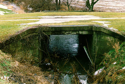 of
the road. The original road ran along side of them, and you should also note the
concrete culvert in front of the white barn.
of
the road. The original road ran along side of them, and you should also note the
concrete culvert in front of the white barn.
A tour might end up at the mile marker at the intersection of state routes 30
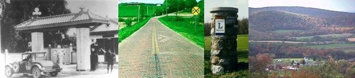
and 183 in Minerva. You may find of interest the 1910's gas station near this
corner which now serves as a gift shop. There is another concrete mile marker
that has only recently been restored to this spot when the a family purchased a
nearby farm and discovered it on their property.
By the end of 1928 the Federal Highway Commission decided not to refer to
highways by names and this part of the Lincoln Highway simply became US Route
30. Through out the 1930's the Minerva to East Canton section was improved to
it's present condition and the original superhighway of brick was retired for
use as back streets or removed altogether.