The Ohio Lincoln Highway Map Room
Help us make this better by sending in your digitized early Ohio road and trails maps. Send us your map.
|
1915 Road system as proposed by the National Highways Association, showing all or parts of 15 states with focus on the Lincoln Highway between New York and Chicago. 2249 KB PDF file. Map from the collection of LHA member David Cole of Santa Maria, California. |
|
|
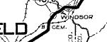
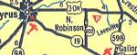
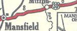
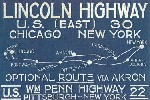
1918 maps published by the LHA (below). These maps could be purchased separately from the LHA as an accessory to the 1918 Complete and Official Guide of the Lincoln Highway. Maps from the collection of LHA member Russell Rein of Ypsilanti MI. |
|
1. Pittsburgh Pa. to Canton Oh. 1539 PDF file. |
|
2. Canton Oh to Upper Sandusky Oh. 1755 KB PDF file |
|
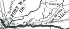
3. Upper Sandusky Oh to Ft. Wayne In. 1754 PDF file. |
|
1921 Pittsburgh to Ft. Wayne, Automobile Club of Southern California. 361 KB PDF file. |
|
Chronology of Ohio Road Maps. By Ohio Director M. G. Buettner. |
|
1929 East Liverpool to Ft. Wayne Texaco map. Map from the collection of LHA member David Cole of Santa Maria, California. Multiple PDF files. |
|
1932 New York to Chicago Hobbs Guide. Map from the collection of LHA member David Cole of Santa Maria, California. Multiple PDF files. |
 |
When on the Lincoln Highway in Ohio, please support these establishments who support our preservation effort. |