The Monuments of Crawford County, Ohio - Part Two, Mile
Markers East Of The City,
By Esther M. Oyster
 Two
additional brick columns, to be erected east of Bucyrus, were planned for spring
of 1918 and would be dedicated to Henry B. Joy, president of the Lincoln Highway
Association, and Mayor Songer. 8 However, by the
following year Joy had resigned to enter wartime service and Frank A. Seiberling
was president, so the honor went to him.
Two
additional brick columns, to be erected east of Bucyrus, were planned for spring
of 1918 and would be dedicated to Henry B. Joy, president of the Lincoln Highway
Association, and Mayor Songer. 8 However, by the
following year Joy had resigned to enter wartime service and Frank A. Seiberling
was president, so the honor went to him.
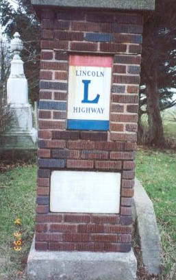
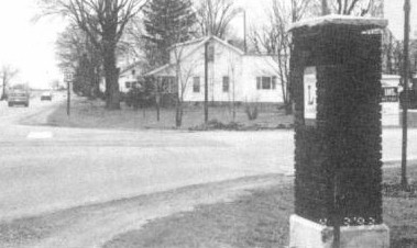
The Songer monument, which originally stood at the east corporation line of Bucyrus on the Bucyrus-Galion Road, was later moved to the Bucyrus-Crestline Road. Ron Simon
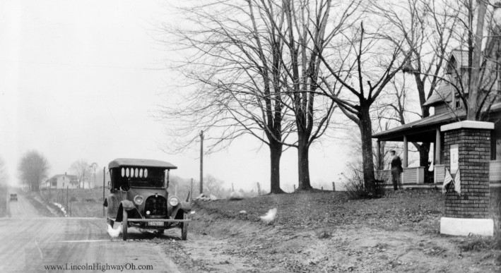
These structures were erected on Lincoln Way east of Bucyrus, on what was then the road to Galion, now Route 19. Songer's was at mile marker one at the city limits, just east beyond Whetstone Street, and Seiberling's was one mile out at the Holmes curve, on the south side of the highway, in front of the farm then owned by a family named Steinhelter and more recently known as the Claude Hull farm.
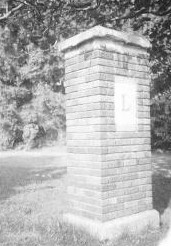
Inscription on the first read:
THIS MARKER DEDICATED TO
E. J. SONGER, CO. CONSUL
LINCOLN HIGHWAY ASS'N.
NOV. 11, 1918
After Lincoln Way was changed in December 1920 to go through Crestline instead
of Galion, this marker was moved to the new route and is located east of the
city, on the south side, between a cemetery and McGlone's Motel.
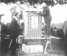
 The
second monument read:
The
second monument read:
THIS MARKER DEDICATED TO
F. A. SEIBERLING, PRES.
LINCOLN HIGHWAY ASS'N .
OCT. 30, 1918
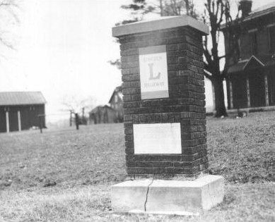
The severe cracks in the base of the Seiberling shaft probably
spelled its doom. 0-149. Lincoln Highway Collection, Special
Collections Library University of Michigan.
Presumably this marker fell, as an early photograph (right) of it shows serious
cracks in the limestone-like base.
At this point in the research, there is no documentation that additional mile
markers were ever erected east of Bucyrus, presumably because of the possibility
the road would be changed to the straight alignment through Crestline.
West Mile Markers
Although not all of the mile markers west of town can be documented, there is
evidence that they were constructed. A newspaper article states 9
that P. Drake & Sons, contractor for the last four-mile stretch of highway to be
bricked in Crawford County, through Oceola, "have put in the base for the
Lincoln Highway markers and will donate the base to the good road boosters.” In
addition, a photograph of west mile marker 4 does exist.
 The
4-mile Marker in Western Crawford County. Lincoln Highway Collection, Special
Collections Library University of Michigan
The
4-mile Marker in Western Crawford County. Lincoln Highway Collection, Special
Collections Library University of Michigan
West mile marker 6 still stands along this last stretch of road to be improved
in Crawford County, being located on a knoll one mile east of Oceola, and
although it does not contain a plaque, it does commemorate the completion of a
brick Lincoln Highway clear across Crawford County. A celebration 10
was being planned, and officials to be invited included Gov. Harry L. Davis, who
would lay the last brick in the highway; State Highway Commissioner Herrick, who
would insert the last brick into the pillar (its capstone being supported by two
boards to allow space for working, this space later to be filled with mortar);
and the state's Lincoln Highway consuls. A. F. Bement, secretary and
vice-president of the Lincoln Highway Association, had signified his intention
of being present, and possibly President J. Newton Gunn.
 West
Mile Marker (right) 6 denoted the completion of the brick highway in Crawford
County, shown by the mortar fill under the capstone. E. M. Oyster
West
Mile Marker (right) 6 denoted the completion of the brick highway in Crawford
County, shown by the mortar fill under the capstone. E. M. Oyster
Mile marker 7 stood in Lincoln Park at the crossroads in Oceola until demolished
in the summer of 1993 by a van which ran off the road, and mile marker 8 was
erected on the southeast corner at the Crawford/Wyandot County line road.
Research will continue with regard to these other pillars.
 This
marker (left) in Oceola, seven miles west of Bucyrus, was demolished in 1993
when hit by a van. Ron Simon
This
marker (left) in Oceola, seven miles west of Bucyrus, was demolished in 1993
when hit by a van. Ron Simon
While the mile markers were all of the same general design, no two were exactly
alike. The use of the bricks in different configurations probably related to the
size of the plaque. The Hopley monument had half bricks at the corners of the
first three rows, and bricks set vertically, sidewise, between them. The
Seiberling pillar had bricks set endwise across the top of the plaque. With
Songer's, the bricks are all in rows, no verticals. The Oceola column had the
vertical bricks at the bottom like the Hopley one, but no plaque. These
variations, once known, make it easier to identify the columns in photographs.
In 1925 a contract was let in Wyandot County for bricking seven miles of the
highway in the eastern part of the county. When completed, a big celebration was
held on August 23, 1925, as documented by a series of photographs in the
archives; and a paving brick, inscribed, “LAST BRICK LAID ON LINCOLN HIGHWAY
BETWEEN UPPER SANDUSKY AND BUCYRUS," was laid by G. F. Schlesinger, director of
Ohio highways. Lt. Gov. Charles Lewis dedicated a nearby brick pillar and
inserted the last brick into it.11 Numerous state and Lincoln Highway
officials were in attendance.
 Lt.
Gov. Charles Lewis inserts the last brick into a marker east of Upper Sandusky
on August 23, 1925. Looking on are State Sen. James Hopley (foreground ) and
Charles Artz, Wyandot County Consul. Bucyrus Historical Museum
Lt.
Gov. Charles Lewis inserts the last brick into a marker east of Upper Sandusky
on August 23, 1925. Looking on are State Sen. James Hopley (foreground ) and
Charles Artz, Wyandot County Consul. Bucyrus Historical Museum
Whether there was a series of mile markers in Wyandot County is unknown.
At one time there were two pillars at the entrance to the L. A. Kuenzli farm12
in eastern Wyandot County, approximately five miles from the county line.
Because Kuenzli had cast the bases and capstones for the pillars, he was given
two of the ceramic signs and had the two markers built at his farm.
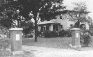 The
Lincoln Highway was well identified at the Kuenzli farm in eastern Wyandot
County. Ohio Historical Museum via Bucyrus Historical Museum
The
Lincoln Highway was well identified at the Kuenzli farm in eastern Wyandot
County. Ohio Historical Museum via Bucyrus Historical Museum
Part One Next - Part
Three Home
Notes
8 Bucyrus Journal, Nov. 11, 1917.
9 Bucyrus Journal, Aug.19, 1921. Also, caption of the photograph of the Hopley
marker in the 1924 Guide states "Ohio has placed many permanent brick Lincoln
Way markers like this."
10 Op. cit.
11 Photo No. O-174; see also O-170 through O-173 and O-175.
12 The farm's address is now 4586 U .S. 30 East, Upper Sandusky.