IN SEARCH OF...
THE PIKES PEAK OCEAN TO OCEAN HIGHWAY IN OHIO
Michael G.
Buettner
December 2005
During the heyday of the named auto trails era, there were four
routes which traversed east to west across Ohio that were parts of
coast-to-coast routes. The boosters of the Lincoln Highway and the National Old
Trails Road were the first to chart their chosen paths, and the wisdom of their
choices in the early 1910s was certainly made evident when the important federal
 numbers 30 and 40 were
assigned in 1926 to long sections of those popular routes. By the middle 1910s,
the Yellowstone Trail had been extended across the northern part of the state,
through Toledo and Cleveland, in a corridor roughly followed by either U.S.
Route 20 or State Route 2. The poor stepchild of the foursome was the Pikes Peak
Ocean to Ocean Highway, which began life in Ohio by sharing the historic route
of the National Old Trails Road before finding an unlikely path of its own.
numbers 30 and 40 were
assigned in 1926 to long sections of those popular routes. By the middle 1910s,
the Yellowstone Trail had been extended across the northern part of the state,
through Toledo and Cleveland, in a corridor roughly followed by either U.S.
Route 20 or State Route 2. The poor stepchild of the foursome was the Pikes Peak
Ocean to Ocean Highway, which began life in Ohio by sharing the historic route
of the National Old Trails Road before finding an unlikely path of its own.
The Pikes Peak Ocean to Ocean Highway Association was formally organized in Missouri in 1914, and like the Lincoln Highway, was dedicated to promoting the improvement and use of a road from New York City to San Francisco. However, west of Philadelphia, the PP-OO (as the highway will hereafter be abbreviated) dipped south to meet the National Old Trails Road at Washington, D.C., tracing that historic road westward through several states before diverging again in Illinois.
The Pikes Peak Ocean to Ocean Highway Association based its name on the fact that the route passed within sight of Pikes Peak in Colorado, perhaps the most famous mountain in the country—although it is not even the highest point in that state, let alone the contiguous forty-eight. The highway was ambitiously promoted as "The Appian Way of America," recalling the most famous route of the Roman Empire. However, highway historian Richard F. Weingroff (www.fhwa.dot.gov) may have attached a more accurate label when he refers to the PP-OO as "a highway that couldn't make up its mind."
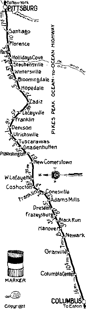
This strip map from the early 1920s shows a short-lived version of the Pikes Peak Ocean to Ocean Highway between Columbus and Coshocton by way of Newark. West of Coshocton, the final version of the route would pass through six county seats that today are on the route of U.S. 36. East of Coshocton, no changes were made to the route in Ohio, and the final route is the same as the route shown on this strip map. This map can be viewed at: www.fhwa.dot.gov/infrastructure/ppmap02.htm
According to Weingroff, the first revision of the PP-OO in Ohio was made in 1916, when the highway was changed to pass through Eaton and Dayton before rejoining the National Old Trails Road at Springfield. This recalled a popular variation of the old Cumberland Road/National Pike of horse and wagon days, which also passed through the Dayton metropolis at the expense of much smaller towns like Vandalia.
A second revision was made at some time before 1921, when a new
route was charted east of Columbus. Following Broad Street all the way through
the state capital, this version passed through Newark and Coshocton (compare to
State Route 16 of today), then continued east to Uhrichsville (see U.S. 36),
Cadiz (see U.S. 250), and Steubenville (see U.S. 22).
By 1926, the final version of the PP-OO would appear on the last auto trails
maps of the day. The route through Dayton, Springfield, and Columbus was shifted
north by one tier of counties, putting six modestly sized county seats on a
seemingly unlikely transcontinental route—Greenville, Piqua, Urbana, Marysville,
Delaware, and Mount Vernon. Most of that route can be followed today by tracing
the route of U.S. 36, with two major exceptions—west of Greenville, the PP-OO
ran northwesterly (not westerly) to enter Indiana at Union City (see today's
State Route 571); and between Coshocton and Mount Vernon, part of an obsolete
routing of U.S. 36 is now designated as State Route 715.
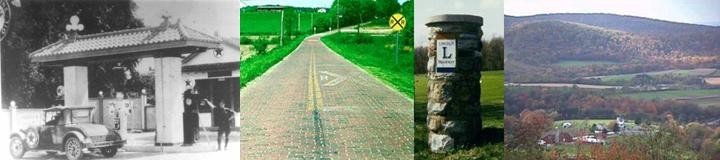
It is significant to note that U.S. Route 36 was one of the last federal routes designated in Ohio, first appearing on the state highway map of 1932. East of Indianapolis, it was not part of the original scheme of federal highways drawn up in the 1920s, and probably came about only as a result of the PP-OO, whose boosters had merely cobbled together several Ohio state routes to form one named trail across the state. However, the route apparently became important enough on a regional basis that it was assigned a federal number of its own.
 At
the time of U.S. 36 being extended into Ohio, the red and white symbol signs of
the PP-OO were probably long gone. At least two versions of the signs were
apparently in popular use—one variation I particularly like is a simple red over
white sign with PP over OO lettered boldly in black on the white field (right);
a second more complex sign featured the white silhouette of the namesake
mountain among the six elements of the highway's wordy name.
At
the time of U.S. 36 being extended into Ohio, the red and white symbol signs of
the PP-OO were probably long gone. At least two versions of the signs were
apparently in popular use—one variation I particularly like is a simple red over
white sign with PP over OO lettered boldly in black on the white field (right);
a second more complex sign featured the white silhouette of the namesake
mountain among the six elements of the highway's wordy name.
In its final form, the PP-OO managed to avoid every major city in Ohio, a practice which the highway's boosters intentionally followed along the entirety of the coast-to-coast route. They claimed that the route was "located so that the tourist can make the best time to the territory where he wants to spend his vacation, instead of spending his vacation in getting there." Farther west, the major interior cities on the final routes were Springfield, Illinois, St. Joseph, Missouri, and Colorado Springs, Colorado. Then, after struggling through Utah with a history not unlike that of the Lincoln Highway, the route passed through Las Vegas, Nevada, which at that time was still "a sleepy desert town" according to Rick and Reed Martin at www.ppoo.org. By 1924, even the western terminus of the route had been changed from San Francisco to Los Angeles.
Given the impermanence of the overall route selection, it comes as no surprise that in Ohio, the PP-OO has largely been forgotten by everyone except highway historians and map collectors. However, according to the Martins, the fourth transcontinental highway is remembered in several Missouri towns where the route had its roots, and an Ocean Trail has managed to survive as a street name in Decatur, Illinois. The Martins had no similar information for the cities and towns of Ohio, leaving this author with a potential project for the future.
It also comes as no surprise that very little of the final route
of the PP-OO in Ohio has been upgraded to a four-lane highway. This is very much
unlike the successor routes of the first three transcontinental routes to cross
the state, which are now approximated by completed interstate highways I-70 (National
Old Trails Road) and I-90 (Yellowstone Trail)
and an incomplete U.S. 30 (Lincoln Highway). The most
significant sections of relocated routes in the PP-OO corridor are near
Steubenville and near Coshocton, with snippets of other modernized roadway near
Uhrichsville and Delaware. Otherwise, the alignment consists of localized
improvements on the two-lane versions of U.S. 36—a statement not only true in
Ohio, but also 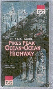 in
states such as Illinois, Missouri, and Kansas.
in
states such as Illinois, Missouri, and Kansas.
Thus, "the highway that couldn't make up its mind" fell quickly
into obscurity in Ohio, and is likely unknown in the corridor of its final
alignment. Although the Pikes Peak Ocean to Ocean Highway claimed to be the
"superlative scenic route...leading to places of beauty and grandeur...[binding]
together the work shops of the industrial centers with the treasure chests of
the mountains," it is probable that most Ohioans would have used one of the
three more historic transcontinental routes on their journeys to the west.
Nonetheless, the final route across Ohio would provide a wonderful cross-section
of small towns that help define America.
This 112-page map guide booklet (right) for the Pikes Peak
Ocean to Ocean Highway, published in 1927, recently sold for over $50 on eBay.
The Roman architecture on the cover helps recall the highway's motto as "The
Appian Way of America." Also on the cover in two corners is one of at least two
symbol signs posted by the boosters of the highway.