IN SEARCH OF . . .
THE THREE-C HIGHWAY
Michael G.
Buettner
February, 2006
Of the forty-plus named automobile trails that appeared on the
state maps during the 1910s and 1920s, perhaps none said Ohio like the Three-C
Highway. This popular route was contained entirely within the state's borders,
and connected Ohio's
![]() three largest cities—Cleveland, Columbus, and Cincinnati.
In this diagonal corridor, which is now the general path of Interstate 71,
variations of the Three-C Highway name are just as familiar to locals as the
Lincoln and Dixie names would be in their respective parts of the state.
three largest cities—Cleveland, Columbus, and Cincinnati.
In this diagonal corridor, which is now the general path of Interstate 71,
variations of the Three-C Highway name are just as familiar to locals as the
Lincoln and Dixie names would be in their respective parts of the state.
I am not certain when the Three-C Highway was first mapped or marked. The
earliest references that I have which show the route are copies of two adjacent
1918 Auto Trails Maps from Rand McNally. These reproduced maps, which cover Ohio
as part of several larger districts, recently came to me from California’s Dave
Cole, map collector nonpareil. A wonderful feature of these maps is the detailed
drawings of the named road symbol signs.
Along with the Three-C Highway, a route labeled as the Two-C
Highway is also shown on these 1918 maps. This route connected Cleveland and
Columbus on a path that passed through Ashland and Mansfield, on a course that
is essentially today’s U.S. 42 northeast of Delaware. The signs of the two named
trails are so much alike that it is my guess that both routes were marked and/or
promoted by the same group. One possible candidate is the Cleveland Automobile
Club, which became Ohio’s first travel agency in 1900. This progressive group
also operated Ohio’s first bureau for registration of automobiles, and was the
first organization in the nation to use radios to dispatch emergency road
service vehicles. Perhaps it is not a coincidence that in their road guide of
1927, the Three-C Highway is one of only a few auto trails mentioned by
![]() name.
name.
The 1918 Rand McNally auto trails maps
featured detailed black and white drawings of the symbol signs for named trails,
including thirty in Ohio. After enlarging and tracing, these are my renderings
of two of those signs. Given that the signs for the Three-C Highway and Two-C
Highway are so similar, it is this author’s guess that the routes were promoted
and/or marked by the same group of boosters. In the text, it is speculated that
the progressive Cleveland Automobile Club could have been such a group. However,
since Columbus got top billing on the sign of the Two-C Highway—a parallel route
through Delaware, Mount Gilead, Mansfield, and Ashland—perhaps it was an
endeavor of that city’s auto club. Or perhaps the two clubs worked together,
with Cincinnati interests also possibly involved for the Three-C Highway.
As originally laid out, the route of the Three-C Highway traced the paths of
four roads from pre-auto history that had been designated as inter-county
highways in 1912. Together, these four highways became
Main Market Route Number
Ten, a designation which appears for the first time on the official highway map
of Ohio in 1914. From Cincinnati to Washington Court House, the route of the
Three-C Highway followed Inter-County Highway #10, which was part of the
Cincinnati-Zanesville Road. From there, the route traced Inter-County Highway
#50 to Columbus. North of Columbus, the highway followed Inter-County Highway
#24 to Wooster, and Inter-County Highway #25 to Cleveland. These roads were
known as the Columbus-Wooster Road and Cleveland-Wooster Road, respectively. It
is noteworthy that two of these same intermediate cities (Washington Court House
and Columbus) would serve as division points for the federal highways which came
a decade later.
When the first state routes were numbered on the official highway map of 1923,
the Three-C Highway was wisely designated as State Route 3. Unlike most of the
original low-numbered state routes, State Route 3 survives today along much of
its original path—with typical minor realignments throughout its length, and one
major rerouting between Medina and Parma. By comparison, the Lincoln Highway
(State Route 5, then U.S. 30) and the Dixie Highway (State Route 6, then U.S.
25) carried their significant one-digit numberings for only three years before
assuming equally important numberings in the federal scheme.
Oddly, no single federal route number was ever attached to the route of the
Three-C Highway. However, by the mid-1930s—when the last of those new numbers
were assigned in Ohio—four different U.S. highways overlapped the Three-C
Highway for some distance along its 260-mile path. Between Cincinnati and
Washington Court House, the Three-C Highway was overlapped by U.S. Route 22.
From Washington Court House to Columbus, the route was common with U.S. 62.
North of Columbus—where the name is most prominent on today’s maps—the Three-C
Highway enjoyed a good measure of independence, except for a brief overlap with
U.S. 36 between Sunbury and Mount Vernon. Between Medina and Cleveland, the
history of the route would be both altered and overlapped by the designation of
U.S. 42.
It is this relationship with U.S. Route 42 that proved to be the inspiration for
this article. When U.S. 42 was marked along the route of the Three-C Highway
between Medina and Parma, highway officials shifted the route of State Route 3
to a parallel path through Hinckley and North Royalton. Thus, there is one
lengthy portion of State Route 3 which has little or no history as part of the
Three-C Highway—something that tends to be missed in present-day articles about
the route. That observation, plus my passion for finding bypassed remnants of
any old road with a colorful history, provided me with a double dose of
motivation for the tracing and charting of the route.
This search for the original route of the Three-C Highway begins in Cincinnati.
Because the Ohio Department of Transportation numbers its mileposts from south
to north (and also from west to east), it made sense to follow that same
pattern—with the idea that some day, when I actually drive the route, I can
correlate straight line mileages to critical points along the route. Presently,
this tour is being prepared after an exhaustive study of maps and guides, with a
little bit of instinct thrown in.
In its original form, the Three-C Highway would have left Cincinnati by
following Eighth Street to Gilbert Avenue and Montgomery Road. By comparison,
today's combination of State Route 3 and U.S. 22 is split because of modern one
way streets (Seventh Street eastbound and Ninth Street westbound), and the two
numbered routes have been extended west to terminate in new locations. The point
of beginning for the Three-C Highway would have been at the corner of Eighth
Street and Race Street—which, according to my 1927 guide book, was also the
location of the Cincinnati Automobile Club.
Montgomery Road follows State Route 3/U.S. 22 through Norwood on the way to its
namesake city, then appears to keep that name as it enters Warren County. At a
point twenty miles from Fountain Square in downtown Cincinnati is the community
of Twenty Mile Stand. This is the home of the historic 20 Mile House, a
restaurant that reportedly opened in 1822 as a stagecoach stop on one of the
state's first wagon roads. According to an article by Randy McNutt of the
Cincinnati Enquirer, "[the house] has been renovated so many times over the
years that it no longer resembles any particular era. But with its many narrow
windows in front, the older section of the restaurant still has a hint of the
1800s."
Two miles beyond Twenty Mile Stand, the present-day numbered routes cross the
Little Miami River at a contemporary bridge in the community of Foster. An older
bridge remains just upstream (north) from the current bridge. Earlier routes of
State Route 3 and U.S. 22 would have crossed that bridge, and roads on each side
of the river are still shown on the county map as Old 3-C Highway.
Seven miles past the two bridges, the routes pass through the small town of
Morrow, where the main street is marked on the county map as Pike Street. Given
that name, and its implications of antiquity, it would seem that the old Three-C
Highway probably followed this same course through town. Another seven miles
from Morrow is a fork in the road at which two versions of State Route 3 split.
The original route of State Route 3—and thus the route of the Three-C
Highway—would have passed through the hamlet of Clarksville. This original route
was replaced in the 1950s by six miles of new alignment that passed to the west
of Clarksville and eliminated two railroad crossings.
To stay with the original route of the Three-3 Highway, angle right at the fork
in the road onto another roadway shown on the county map as Old 3C Highway (this
remnant may also be marked as County Road 10A). After a short distance, this
road meets with State Route 350, crossing the county line and entering into
Clarksville. At the center of Clarksville, turn left (north) from State Route
350 onto D Street, which then angles onto First Street before leaving town on
Clarksville Road. Continue northeasterly with Clarksville Road for about four
miles, rejoining today's main highway at the crossroads community of Sligo.
At Sligo, turn right (east) onto State Route 3/U.S. 22 and the city of
Wilmington will be five miles ahead. Wilmington is the seat of Clinton County,
and on most maps appears to have two main east-west streets. Thus, the numbered
routes may now be divided onto one way streets, with Main Street carrying
eastbound traffic, and Locust Street carrying westbound traffic. The Clinton
County Courthouse at the heart of downtown was completed in 1919, making it one
of the newer courthouses in the state. According to County Courthouses of Ohio—a
splendid book published in 2000—it is "very similar to [the pre-Civil War]
appearance of the U.S. Capitol, before the addition of the House and Senate
wings."
From Wilmington it is another twenty-two miles to Washington Court House, the
seat of Fayette County. The route is remarkably straight between the two
cities—perhaps another early wagon road—with the halfway point of Sabina being
the only town of note. State Route 3 passes through Washington Court House with
a simple combination of Clinton Street and Court Street, with no one way streets
apparent on the maps. I have visited this city only once, as part of an ongoing
adventure to visit each of the eighty-eight county courthouses in Ohio. The
Fayette County Courthouse, completed in 1885, was memorable for its impressive
staircase and murals. I also appreciated the setting of a courthouse and
adjacent grounds which have one prominent city block all to themselves.
In Washington Court House, the route of the Three-C Highway and State Route 3
will join with U.S. 62, then diverge from U.S. 22. Leaving the city, the
numbered highways point northeasterly toward Columbus on another unusually
straight course that holds direction for about fourteen miles, until reaching
Mount Sterling—a small town in the southeast corner of Madison County.
It is at Mount Sterling where the next significant relocation of State Route 3
can be found. This relocation, constructed in the 1930s, includes an overpass of
the old Baltimore and Ohio Railroad near the flyspeck community of Era. Of the
several relocations described in the text, this one may be the most interesting
because the roadway which it replaced no longer shows up on any county or
geologic survey maps. This mysterious remnant—running south to north between the
new alignment and the railroad, not far from the west bank of Deer Creek—is also
not discernable from any aerial photography that can be viewed on the internet.
This is how the preferred route between Washington Court House and Columbus was
described in the 1922 Automobile Green Book:
0.0 Washington Court House. Leave south side square, Court St. Go east...
16.2 Mount Sterling. Town Hall. Turn to left. Main St.
16.8 Angle to left.
17.6 Cross railroad. Turn to right through covered bridge.
Cross railroad again. Bear to left.
18.4 Era.
In actuality, there were three grade crossings of the railroad
in the short half-mile distance approaching Era. This becomes apparent when
tracing the reverse description for the route (always a good check for projects
such as this). The locations of the grade crossings—which no longer exist—can be
approximately determined by projecting tangent portions of the road now shown on
the map as Era Road (or County Road 500). Sadly, it seems that the covered
bridge after milepost 17.6 is no longer there, because it is not shown on the
map published in DeLorme's Ohio Atlas and Gazetteer, which generally indicates
such landmarks.
 The
reverse description of the route also does a better job of charting the old
course through Mount Sterling, where a one block jog from Columbus Street to
Main Street was made in 1922. The description at milepost 16.2 would have been
improved by a call for a right turn onto Main Street (from London Street). Today
it appears that the numbered routes are split into one way streets along the
same main streets which were once connected by the short jog.
The
reverse description of the route also does a better job of charting the old
course through Mount Sterling, where a one block jog from Columbus Street to
Main Street was made in 1922. The description at milepost 16.2 would have been
improved by a call for a right turn onto Main Street (from London Street). Today
it appears that the numbered routes are split into one way streets along the
same main streets which were once connected by the short jog.
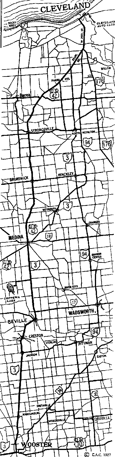
Click to enlarge map. This strip map and
the one below of the Three-C Highway between Cleveland and Columbus are typical
of many such maps in that same route book.
Beyond the potentially fascinating explorations at Mount Sterling and Era, it is
not long before another significant section of old road remnants can be traced.
Six miles northeast of Era, the town of Harrisburg was bypassed with new
construction in the late 1930s. The original route can be traced through
Harrisburg by simply following Harrisburg Road/County Road 501 into town, and
making a right turn (east) onto Columbus Street to rejoin the present numbered
routes. Another remnant from the same decade is one-half mile northeast of this
junction point, and is marked on the Franklin County map as Old Harrisburg Road.
It lies east of the present main road, between a bridge over Big Darby Creek and
an underpass of the railroad.
In Franklin County, State Route 3/U.S. 62 is also marked as Harrisburg Pike
southwest of Columbus. The old pike road also becomes Broadway through Grove
City, which lies between the interchanges of Interstate 71 and Interstate 470.
In reviewing the official Ohio highway maps of the early 1960s, I was rather
amazed at how quickly long stretches of Interstate 71 were built southwest of
Columbus. On the 1962 map, I-71 is merely a dashed "future location" line from
Cincinnati to Harrisburg, with part of the route complete between Harrisburg and
Columbus. By 1965, seventy-seven additional miles of I-71 were complete from the
Cincinnati Bypass to Harrisburg. Similar progress was made in building
Interstate 71 northeast of Columbus. The 1959-1960 ODH map shows nothing more
than a dashed "under construction" line between Columbus and Medina. That entire
length was shown as complete on the map of 1962.
Based on the 1926 ODH map of Columbus, the route of the Three-C Highway would
have continued northeasterly into Columbus with Harrisburg Pike before angling
left (north) onto Central Avenue for several blocks. From Central Avenue, the
route would have turned right (east) on Broad Street—the route of the National
Road in the 1800s, and the route of the National Old Trails Road and U.S. 40 in
the 1900s. The U.S. 40 designation still survives on Broad Street today.
Several blocks after passing the State Capitol, the Three-C Highway would have
turned left (north) onto Grant Street, which then becomes Cleveland Avenue after
a slight change of direction. As I recall, these streets are all two-way
streets, making the old route through Columbus very much traceable today. By
comparison, State Route 3 and U.S. 62 are diverted onto a combination of
downtown one way streets that have no history as part of the Three-C Highway.
State Route 3 rejoins the route of the Three-C Highway on Cleveland Avenue, but
U.S. 62 finds an identity of its own as a federal route to Canton. State Route 3
and Cleveland Avenue overlap for just over four miles before Cleveland Avenue
angles north. The route of the Three-C Highway continues on a diagonal course
toward Westerville on a roadway that is variously shown on the maps as
Westerville Pike, Westerville Road, or Columbus-Wooster Road.
Westerville is one of a half dozen booming satellite cities in the orbit of the
I-470 bypass around Columbus. Like Dublin, Gahanna, Grove City, Hilliard, and
Reynoldsburg, Westerville has tripled in population since the completion of the
outerbelt in the mid-1970s. The corporate limits of Westerville have now
expanded into the south part of Delaware County, becoming the gateway to that
portion of the old Three-C Highway where the historic name is most prominent on
modern maps.
In 1924, Westerville reportedly hosted a large ceremony to celebrate the opening
of the Three-C Highway. However, based on that date—six years after the highway
is shown on the referenced 1918 map—it seems more likely that the ceremony was
for the opening of some local improvement of the highway. Either that, or the
dedication could have been for the newly designated State Route 3. Nonetheless,
it was a big event with a grand parade and the crowning of a highway queen.
Between Westerville and the crossroads community of North Condit, twelve miles
of original alignment are marked as Old 3-C Highway. Beyond Westerville, State
Route 3 now bypasses the small towns of Galena and Sunbury on a new path that
was constructed in the early 1950s. Immediately north of Westerville, the old
road angles right (northeast) from State Route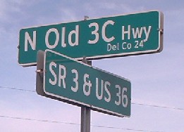 3 and eventually bends around the northwest side of Hoover Reservoir before
arriving in Galena. Through tiny Galena, the route follows Columbus Street,
Walnut Street, and Harrison Street before leaving town and reassuming its
designation as Old 3-C Highway.
3 and eventually bends around the northwest side of Hoover Reservoir before
arriving in Galena. Through tiny Galena, the route follows Columbus Street,
Walnut Street, and Harrison Street before leaving town and reassuming its
designation as Old 3-C Highway.
A similar set of right angle turns is also negotiated in the budding antique
mecca of Sunbury, but without a physical visit to the town, I am not exactly
sure which streets are the most correct to follow. Here is the description of
one charted course from Columbus to Cleveland, but the only one that passed
through Sunbury—again from the 1922 Automobile Green Book:
24.8 Sunbury. Turn right at northwest corner City Hall. Jog left and right to pike.
Beyond the town line of Sunbury, the Old 3-C Highway designation
again appears on the county map. After the historic route crosses the
present-day version of State Route 3, it meanders wildly for almost four miles
before meeting the numbered route again at an intersection just east of North
Condit. However, pay attention to a mile of parallel highway east of the new
alignment which is marked as Locust Drive. Although not carrying a label as Old
3-C Highway, my map-reading instincts hint
 that
Locust Drive may also be a bypassed segment of the historic route.
that
Locust Drive may also be a bypassed segment of the historic route.
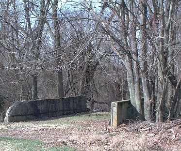
Bypassed concrete
bridge north of Sunbury, Ohio, on Old 3C Highway.
Continuing into Knox County, the route of the Three-C Highway is also shared by
the pairing of State Route 3 and U.S. 36. The federal route joined the state
route back at the bypass around Sunbury, and the two numbered routes share the
same course all the way to Mount Vernon before U.S. 36 diverges east toward
Coshocton. The route of U.S. 36 is also the final version of the route of the
Pikes Peak Ocean-To-Ocean Highway—the second of
four east-west transcontinental routes that would be overlapped for at least a
short
 distance
by the Three-C Highway.
distance
by the Three-C Highway.
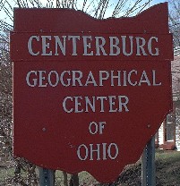
Centerburg is the geographical center of Ohio.
In Knox County, the route of the Three-C Highway passes through Centerburg and continues northeasterly toward Mount Vernon. Centerburg is so named because it is near the geographical center of Ohio. Southwest of Mount Vernon, the shared paths of State Route 3 and U.S. 36 follow a new alignment that squares up to meet State Route 229 before entering the west side of the city. The route of the Three-C Highway would have followed the diagonal now marked as Columbus Road, which meets up with Main Street to enter the downtown. Main Street and the Three-C Highway would have continued north to pass through the traffic circle at the center of Mount Vernon. The Greek Revival style Knox County Court House—completed in 1856, and now the eighth oldest courthouse in Ohio—is just east of this rare rotary.
As Main Street and State Route 3 leave downtown Mount Vernon,
the old highway angles to the right and becomes Wooster Road, with the town of
Loudonville twenty-three miles ahead. Among the hills and along the way, two
locations with fascinating names are shown with tiny circles on the Ohio
map—Amity and Jelloway. Amity has also been known as Democracy, curiously giving
it two names with high moral aspirations, perhaps a hint of its early history as
a Quaker settlement. Jelloway is reportedly an anglicized rendering for the name
of a Native American chief whose tribe often camped near this site. I was
reasonably certain there there was no connection with the popular dessert.
Two miles past Jelloway, the route of the Three-C Highway enters Ashland County.
In the area of Mohican State Park is a parallel roadway (County Road 739) which
could be a previous alignment of the historic route. I just could not be sure
with the limited information in my files. This is one of those areas where
having a copy of the early U.S. Geological Survey
 quadrangle
sheet would be helpful. Thus, a visit to the ODNR office in Columbus is in my
future.
quadrangle
sheet would be helpful. Thus, a visit to the ODNR office in Columbus is in my
future.
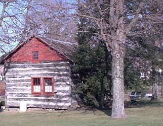
1804 Workman cabin in Central Square,
Loudonville, Ohio.
At Loudonville, State Route 3 now enters town on a newer roadway that connects
to Market Street. Originally, the Three-C Highway would have entered the west
side of town by way of Mount Vernon Avenue and Main Street. After passing
through the center of town, the route turns left (north) from Main Street onto
Union Street, then turns right (east) onto Washington Street. After a couple
blocks, the route resumes a northeasterly course toward Wooster, but not before
clipping the northwestern most corner of Holmes County.
Four miles after entering Holmes County, roadfans have the choice of following
two routes which have a history as part of State Route 3. However, it is the
convoluted route now marked as State Route 226 which was the route of the
Three-C Highway in 1918. This same path through Lakeville and Shreve was also
the original version of State Route 3 when it first appeared on the Ohio map of
1923. The important state route did not assume its direct diagonal course
through Craigton and Springville until 1927, with the completion of several
years of improvements. Then, after going through a hodgepodge of renumberings,
the original State Route 3 through Shreve became State Route 226. In the village
of Shreve, an old road remnant survives as a short section of Centerville Road.
Two miles north of Shreve, County Road 226A is also marked as Old Shreve Road,
and probably is another remnant of the original alignment.
While all the new construction was going on, either the Three-C Highway boosters
or the Ohio Department of Highways (or perhaps both) began to chart a detour
route that altogether avoided this area. This detour route veered north from
Loudonville to Hayesville, where the route of the Three-C Highway joined the
Harding Highway, and the future path of the Lincoln Highway. Thus, for several
years, the Lincoln Highway locations of Jeromesville, Reedsburg, and Jefferson
were also on a temporary version of the Three-C Highway. This matter is
confirmed by a Rand McNally Auto Trails Map from 1926, which shows nothing more
than poor unimproved roads on the direct diagonal between Loudonville and
Wooster, but solid black lines and pertinent codes for the temporary route of
the Three-C Highway through Hayesville.
This detour through Hayesville and Jeromesville was significant enough to merit
a unique symbol on the official ODH maps dated 1924 through 1926. This came at a
time before the now-familiar number-in-circle symbol was being used for state
highways. On these early maps, the number 3 was enclosed in a small square, much
like the standard temporary route number signs that would have been placed along
the highway.
Southwest of Wooster, State Route 226 ends at its junction with State Route 3,
which now takes on another new alignment to enter the city. In the early 1960s,
the route’s entrance into Wooster was changed from Spruce Street and Market
Street—on the south side of the city—to Columbus Avenue and Liberty Street, on
the west. With this revision, an adequate interchange could be made with the
U.S. 30 Bypass—opened in the mid-1960s. In the late 1960s, one mile of four-lane
 divided
highway was constructed on a totally new State Route 3 alignment that bypassed
the Westwood neighborhood.
divided
highway was constructed on a totally new State Route 3 alignment that bypassed
the Westwood neighborhood.
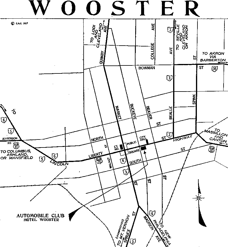
(Click) This map of Wooster is an example of
several dozen city maps in the Automobile Route Book published by the Cleveland
Automobile Club in 1927.
To trace the original routes into and through Wooster, continue northeasterly
with Old Columbus Road and Spruce Street to reach Market Street. After following
Market Street for a few blocks, the routes then turn right (east) onto Liberty
Street at the Public Square. The Wayne County Court House is at the northwest
corner of this square. The routes again change direction after only a few
blocks, turning left (north) from Liberty Street onto Beall Street, soon passing
the campus of the College of Wooster. Beall Street then ends and angles onto
Cleveland Road. After following bypasses around the south and east sides of the
city, State Route 3 rejoins the old Three-C Highway at an interchange with
Cleveland Road.
From the interchange on the north side of Wooster, the route of the Three-C
Highway travels northerly with State Route 3 for
 about
ten miles to Creston. Just beyond Creston, the routes enter Medina County, where
they turn east and northeast to enter the small town of Seville on a road marked
as either Wooster Pike or Pleasant Street. The Three-C Highway then follows
State Route 3 through the small downtown by angling right (east) onto Main
Street and then turning left (north) onto Center Street. Beyond the town line,
the Wooster Pike name is restored. Then, after nine miles, State Route 3 and the
route of the Three-C Highway arrive at Medina, the seat of Medina County.
about
ten miles to Creston. Just beyond Creston, the routes enter Medina County, where
they turn east and northeast to enter the small town of Seville on a road marked
as either Wooster Pike or Pleasant Street. The Three-C Highway then follows
State Route 3 through the small downtown by angling right (east) onto Main
Street and then turning left (north) onto Center Street. Beyond the town line,
the Wooster Pike name is restored. Then, after nine miles, State Route 3 and the
route of the Three-C Highway arrive at Medina, the seat of Medina County.
The main north-south street in Medina is signed as Court Street, which
apparently fronted the first courthouse in the county seat. The courthouse of
today is at the southeast corner of Broadway and Liberty Street—one block east
of Court Street. A Greek Revival courthouse completed in 1841 is now enveloped
by a French Second Empire facade that was completed in 1873. The 1841 structure
would be the second oldest courthouse among the eighty-eight counties of Ohio.
In 1963, another contemporary courthouse facility was annexed to the earlier
structures.
Between Medina and Parma, two present-day numbered routes have histories as
State Route 3. However, the route of the Three-C Highway would have followed the
highway now marked as U.S. 42 and Pearl Road, passing through Brunswick and
Strongsville—which were small communities of only 200 people in the earliest
days of the named trail. Today, over 35,000 people call Brunswick home, and the
population of Strongsville is now over 44,000. From 1923 and 1926—before the
adoption of the federal highway numbers—Pearl Road was also the original path of
State Route 3. Then in 1927, when U.S. 42 became official, the state route was
relocated to its present course through Hinckley and North Royalton, with some
alterations in the vicinity of Weymouth.
Like Brunswick and Strongsville, Parma is also an interesting study in suburban
growth. Although Parma Heights was incorporated in 1912, the city we now know as
Parma did not appear on the Ohio map until 1930—although one source says that
Parma was incorporated in 1924. This came at a time when there was a trend to
incorporate entire townships as suburban cities, and that is exactly what
happened with old Parma Township and other townships in Cuyahoga County. Parma
is now the eighth largest city in Ohio, with a population of 84,000.
In 1993, the April and May issues of OHIO Magazine featured a two-part article
by freelance journalist Sue Gorisek, entitled “Travel the Road That Time
Forgot.” This tourist-friendly story eloquently highlighted the many unique
shops and eateries that Sue discovered on a north-to-south journey of the
Three-C Highway. She also captured a fascinating identity specific to each
waypoint of the route—whether it be the attractive seats like Medina or Mount
Vernon, or forgotten spots on the map like Academia and Bangs. Sue even points
out some abandoned pieces of old pavement that parallel the present roadway near
Craigton. Typical of her fine writing style, Sue describes Parma as “the
prototype postwar suburb of the 1950s, a city of little homes and big churches
that grew up around the auto plants and steel mills of Cleveland’s South Side.”
At the junction of Pearl Road and Ridge Road in Parma, State Route 3 and U.S. 42
join together and share a common path into Cleveland. Eventually, Pearl Road
becomes 25th Street and enters the city’s West Side neighborhood. Highway
historian Frank Brusca curiously reports that the traditional endpoint of the
Three-3 Highway is where 25th Street intersects Detroit Avenue, but the
Cleveland Automobile Guide has a route which continues to downtown. This seems
agreeable to me, so our charted course will follow that same lead.
Thus, at the intersection of 25th Street and Detroit Avenue, our routes turn
right (east) to cross the Cuyahoga River by way of the majestic Detroit-Superior
Bridge. The bridge takes its name from the streets it connects. According to one
web site, “When [it was] opened in 1918, it was the largest double-decked
concrete bridge in the world." It was also "the first non-movable bridge built
on the Cuyahoga...because there was a need for a bridge that vessels could pass
underneath without opening and closing the span." It is indeed a fabulous
structure, and provides a climactic photo opportunity near the end of this
diagonal tour across Ohio. For more details about the bridge, see
crainscleveland.com for some
wonderful old post card views, see
kingbridgeco.com.
According to the straight line diagrams of the Ohio Department of
Transportation, the routes of State Route 3 and U.S. 42 terminate at Cleveland's
Public Square. However, the path of the Three-C Highway could very well have
continued on to the old Hollenden Hotel, which was the home of the Cleveland
Automobile Club. The hotel—demolished in 1963—was on the southeast corner of
Superior Street and East Sixth Street. The hotel may also have been the travel
office of the Yellowstone Trail—which similarly followed Superior Street through
the downtown area, becoming the fourth transcontinental route partially
overlapped in this journey by the route of the Three-C Highway.
Ironically, one reason the named automobile trails were eliminated was because
of the confusion in tracing a multitude of overlapping routes and their jumbles
of symbol signs. Thus, it is amusing to note that in the 1927 guide book, at
least nine numbered state or federal routes either passed through the Public
Square in downtown Cleveland, or had endpoints there. By my reckoning, State
Routes 2, 3, 8, and 14 met this criteria, as did U.S. Routes 20, 21, 42, 322,
and 422. When U.S. 6 was certified in 1932, it also passed through the square,
running the federal count to a half dozen all by itself. Surprisingly, most of
these same state and federal routes can still be found in and around downtown
Cleveland today—and the feds said that tracing the named trails was confusing!
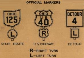 The
official Ohio Department of Highways map of 1927 showed three standard signs for
numbered highways in the state. Along with the familiar shields for state and
federal routes, a special sign was posted for significant detour routes. In the
mid-1920s, the Three-C Highway was detoured in such a way between Loudonville
and Wooster, passing through Hayesville and Jeromesville on the future line of
Lincoln Highway.
The
official Ohio Department of Highways map of 1927 showed three standard signs for
numbered highways in the state. Along with the familiar shields for state and
federal routes, a special sign was posted for significant detour routes. In the
mid-1920s, the Three-C Highway was detoured in such a way between Loudonville
and Wooster, passing through Hayesville and Jeromesville on the future line of
Lincoln Highway.
In closing, this best reckoning of the route of the Three-C Highway has passed
through parts of fourteen Ohio counties, and through eight county seats. Three
of those county seats—Cleveland, Columbus, and Cincinnati—are also the major
metropolises which gave the highway its name. However, smaller cities like
Medina, Mount Vernon, Washington Court House, Wilmington, and Wooster also give
the highway an identity, with their own special treasures to enjoy. Lastly, the
Three-C Highway has a name recognition in its home areas that compares well to
the Lincoln Highway and Dixie Highway, and was the first important auto route in
a corridor now occupied by a busy Interstate 71. It certainly deserves
consideration as one of Ohio’s most important named auto trails.
|
SELECTED BIBLIOGRAPHY Brusca, Frank. “Gimme 3C.” American Road Magazine. Volume II Number 1.
|
|
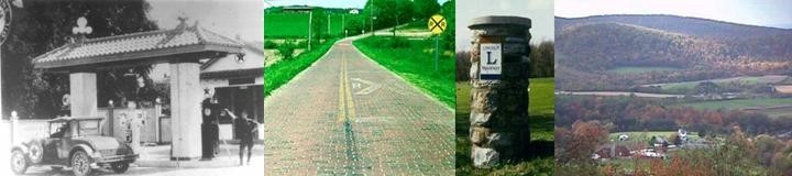
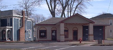
SELECTED ROADSIDE POINTS OF INTEREST Wilmington—General Denver Hotel |
Centerburg—Renovated 1940s Mobil Oil station. |