IN SEARCH OF . . .
U.S. ROUTE 20 IN OHIO
Michael G.
Buettner
February, 2006
Just as Ohio was crossed by four coast-to-coast named auto
trails, so also was the Buckeye State traversed by four nationally
 important
east-west federal routes. While the Lincoln Highway and National Old Trails Road
generally became U.S. Routes 30 and 40, respectively, two other federal
routes—numbered 20 and 50—followed paths with ties to named trails that were
more regional in nature. This article will focus on the route of U.S. 20, which
most closely followed a route known as the Chicago-Buffalo Road.
important
east-west federal routes. While the Lincoln Highway and National Old Trails Road
generally became U.S. Routes 30 and 40, respectively, two other federal
routes—numbered 20 and 50—followed paths with ties to named trails that were
more regional in nature. This article will focus on the route of U.S. 20, which
most closely followed a route known as the Chicago-Buffalo Road.
When the federal highway system was first drawn on the national map in 1925,
U.S. 20 was a transcontinental route from Boston, Massachusetts to Astoria,
Oregon by way of Yellowstone National Park. However, interests in Utah, Idaho,
and Oregon apparently wanted some numerical connection with U.S. 30, which—in
return for the pledge of the Lincoln Highway Association to support the new
federal system—generally had become the important equivalent of the Lincoln
Highway. These three states were successful in their efforts, and as a result,
the course of U.S. 20 was revised to terminate at the east entrance of
Yellowstone Park, while the course of U.S. 30 was routed to Astoria, Oregon—much
like it is today. However, some compromise was evident, because 30-North (via
Pocatello, Idaho) and 30-South (via Ogden, Utah) both appeared in the first
official log of United States numbered highways as diverging routes west of
Granger, Wyoming.
Eventually, U.S. 20 was extended to the Oregon coast. During the 1940s, a newly
improved road was opened to Albany, Oregon. By the 1950s, the terminus had been
shifted another fifty miles westward to meet the Pacific Ocean at Newport,
Oregon. This actually created a rare anomaly in the national numbering scheme,
with U.S. 20 traversing the final western state between U.S. 30 and U.S. 40.
At its maximum length, U.S. 20 reportedly covered over 3400 miles from Boston,
Massachusetts to Newport, Oregon. Then, with the truncation of U.S. 6 in
California during 1965, U.S. 20 became the longest of all the federal routes,
although now listed on the FHWA (Federal Highway Administration) web site at
3365 miles. According to a 1928 report by the Ohio Department of Highways, 263
miles of the route were in Ohio.
When U.S. 20 first appeared on the official Ohio highway map in 1926, it traced
the paths of four state routes that had been designated only three years prior.
The new federal route followed the original course of State Route 2 westerly
from the Pennsylvania line through six Ohio counties to a point eleven miles
west of Fremont at an intersection locally known as Busy Corners. On the Rand
McNally auto trails maps of 1918 and 1921, this is the same path as the
Toledo-Cleveland-Buffalo Trail, and it also compares well with
Main Market Route
Number One. In addition, there was some overlap in this section with the route
of the Yellowstone Trail. After the federal highway was mapped, the resilient
State Route 2 was relocated to its present corridor along Lake Erie.
Curiously, U.S. 20 has historically avoided Toledo, following the original State
Route 102 across the Maumee River at the bridge between Perrysburg and Maumee.
The route then turned north toward Sylvania on a highway originally marked as
State Route 63, before resuming west toward Indiana on a highway originally
marked as State Route 23 (not to be confused with U.S. 23). This westerly course
was also on the path of the Toledo-Angola-Goshen Trail, which met the Lincoln
Highway in northern Indiana to create the shortest route between Toledo and
Chicago.
From the Pennsylvania state line to Cleveland, the first course of U.S. 20 is
much like the route of today. As early as 1947, the state map shows multiple
lanes throughout this same length, but with Interstate 90 (completed in the
early 1960s) and State Route 2 (presently extending east to Painesville) now
providing the same corridor with two major freeways, U.S. 20 has probably seen
little change through Ashtabula County and Lake County in the last sixty years.
Almost all of the road remnants that do survive near today's alignment occur
where new bridges have been built across rivers or where grades have been
separated at railroads. Thus, bits and pieces of old U.S. 20 can be found in
Ashtabula (river bridge), Geneva (grade separation), and Painesville (grade
separation).
In Conneaut, the original version of the present viaduct over the Conneaut River
was completed just in time for the coming of U.S. 20. The builder's plate shows
construction dates from 1922 to 1924. Predecessors of the federal route had
crossed the river on an extension of Main Street—now known as Old Main
Road—which lies just downstream (north) of the present crossing. According to
the 1927 route book, the federal route followed State Street through the
business district before being directionally split in a much later decade.
Today, the westbound traffic of U.S. 20 follows State Street while eastbound
traffic follows Main Street.
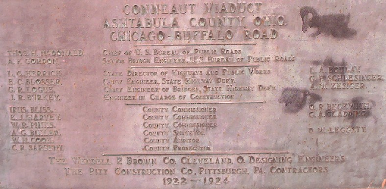 (Click
to enlarge) Builder's plate mounted at the Conneaut Viaduct on U.S. 20, also
known as the Chicago-Buffalo Road.
(Click
to enlarge) Builder's plate mounted at the Conneaut Viaduct on U.S. 20, also
known as the Chicago-Buffalo Road.
In Ashtabula, another new bridge was still under construction in 1927, according
to the line conventions of the Cleveland Automobile Club's route book. Thus, the
original course of U.S. 20 turned left (south) from Ridge Road to jog around a
park (see today's Edgewood Drive) before continuing south on State Road. The
Ashtabula River was then crossed after a right turn (west) onto what is now 46th
Street, which in the 1920s was apparently known as Spring Street. This was
followed by a left turn (south) in downtown onto Main Street, and a right turn
(west) onto Center Street, before another left turn (southwest) onto Prospect
Street took the route out of town. After completion of the new bridge, an
extension of Ridge Road would meet an extension of Prospect Street to eliminate
every one of those previous turns.
There are actually numbered routes following two ridge roads through the
northeasternmost counties of Ohio. The route of U.S. 20 follows the north ridge,
and State Route 84 follows the south ridge—both running parallel with the
shoreline of Lake Erie. According to the 1920 Automobile Blue Book, the
Yellowstone Trail followed the south ridge from Kingsville to Painesville,
skirting the south sides of town in Ashtabula and Geneva. Later maps in that
same decade have the Yellowstone Trail on the same path as U.S. 20 and the
Chicago-Buffalo Highway.
West of Geneva, a railroad underpass on a newer alignment has rendered two short
road remnants on each side of the railroad. A photogenic brick street marked on
the map as West Main Court is on the east side of the tracks, and another
 marked as Romeo Road
is on the west side of the tracks.
marked as Romeo Road
is on the west side of the tracks.
A brick road remnant on the old main street at
the west edge of Geneva, rendered by the construction of a railroad grade
separation.
On the east side of Painesville, another grade separation has eliminated a
second harshly skewed railroad crossing. However, this underpass was built on a
north-south road that required two new right angle turns in the federal route.
Both of these turns have since been reconfigured. A significant stretch of old
roadway may be found along the south side of the railroad and east of this
underpass.
Through the business district of Painesville, the north ridge route of U.S. 20
follows Erie Street and Mentor Avenue. The parallel route on the south ridge
would have passed through downtown on Main Street and Mentor Avenue, with an
interesting jog around a small central park near the Lake County Courthouse.
Mentor Avenue continues through its namesake city on its way to Willoughby. In
Willoughby, the route of U.S. 20 turns onto Euclid Avenue and passes through the
communities of Wickliffe and Euclid with no change of the street name.
Today's version of U.S. 20 enters downtown Cleveland by way of Euclid Avenue,
but this is not the original course of the highway. From 1926 to 1968, the
federal route diverged from Euclid Avenue and reached the Public Square by
following Superior Avenue. When U.S. 6 was certified in 1932, it also followed
Superior Avenue, where it remains today. Between 1936 and 1968, an alternate
U.S. 20 route was awkwardly paired with an alternate U.S. 6 route on the Euclid
Avenue entry. One can only speculate why the highway department waited until
1968 before simplifying this overload of numbers to the present practical
arrangement.
After passing through the Public Square in downtown Cleveland, the original
route of U.S. 20 continued west across the Detroit-Superior Bridge. Beyond the
west end of the bridge, the highway followed a boulevard which passed through
the Edgewater Park neighborhood. Today this same modernized corridor is occupied
by a trio of numbered highways, with State Route 2 and U.S. 6 now joined with
U.S. 20.
At the west end of the boulevard, the 1927 route book of the Cleveland
Automobile Club has the route following Lake Avenue to a point in Lakewood just
beyond Webb Road, where it met the trolley on Clifton Boulevard. After short
southbound stints on Clifton Boulevard and Riverside Drive, the 1927 course
turned west and crossed Rocky River by way of the Hilliard Bridge. After six
tenths of a mile on Hilliard Boulevard, the route turned south on Wooster Road
for half that previous distance before resuming west into then-rural areas with
yet another ridge road known as Center Ridge Road.
Oddly, the reverse course charted in the 1927 route book follows a different
path through the Lakewood and Rocky River area. The eastbound route traces
Hilliard Boulevard to Warren Road, where it turned north to meet the east-west
portion of Clifton Boulevard. The 1927 route then followed Clifton Boulevard
easterly toward downtown Cleveland. Thus, it appears that one-way streets may
have existed in this area as early as the 1920s, with Lake Avenue carrying
westbound traffic and Clifton Boulevard carrying eastbound traffic.
Not surprisingly, the course of U.S. 20 has been changed at least once since
that first pair of alignments. Today the route crosses Rocky River on a section
of Detroit Avenue that lies between a north-south leg of Clifton Boulevard and
Wooster Road. According to straight line diagrams from the highway department,
Sloan Avenue is now also part of the federal route. Moreover, U.S. 20 is now
apparently on a two-way version of the east-west section of Clifton Boulevard,
with Lake Avenue no longer carrying any highway number.
The route of U.S. 20 leaves Cuyahoga County and then passes through North
Ridgeville on its way to Elyria, the seat of Lorain County. On the east side of
Elyria, the present route of U.S. 20 follows a bypass alignment around the east
and south sides of the city before approaching the original route on the
southwest side of the city. The old route through Elyria follows southwesterly
courses on Cleveland Street and Bridge Street before angling westerly onto Broad
Street. After a left turn from Broad Street, the route resumes south with Middle
Avenue, then angles southwesterly onto Oberlin Avenue, which becomes
Oberlin-Elyria Road beyond the city limits. A snippet of roadway marked on the
county map as Hall Road may have been a previous alignment of U.S. 20.
Oberlin appears to be the first town in Ohio to be bypassed with a new alignment
of U.S. 20. The federal route was relocated to new construction around the south
side of Oberlin at some time around 1941. This was an alignment which had first
appeared on the official highway map in 1938, but its designation at that time
was State Route 585. The 1927 route through Oberlin follows what is now State
Route 511 through the heart of the historic college town, where it is marked as
Lorain Street. However, there is some evidence to support that College Street
may also have hosted the federal route in other years.
Beyond Oberlin, State Route 511 bears westerly for several miles before turning
south to pass through the community of Kipton. The east-west road is also known
as Oberlin-Norwalk Road, and the north-south road is also known as Vermilion
Road. One mile south of Kipton, the route of U.S. 20 is rejoined after a
quarter-circle turn to the west. Years ago, the highway department used to add
these curves rather freely at state route intersections, but currently is making
it a practice to eliminate them because of safety concerns in merge areas.
Two miles beyond the quarter-circle turn, the highway enters Huron County and
jogs through the village of Wakeman. It is believed that the present U.S. 20 jog
through Wakeman—which also features quarter-circle turns—is not the location of
the original route. It is more likely that the early version of U.S. 20
zigzagged through town with the highways now marked as State Routes 60 and 303.
Bearing west from Wakeman, the county seat of Norwalk is eleven miles ahead.
Like Elyria, Norwalk has also been bypassed by a modern alignment of U.S. 20.
The Norwalk bypass features a divided set of four lanes and several interchanges
that were completed in the late 1960s. The original route enters the city on
Townsend Avenue, then angles southwesterly onto State Route 61, which is also
marked as Main Street. A second route into the city—now marked as Cleveland
Road—was built in later years to eliminate two railroad grade crossings. It
joins Main Street just three-tenths of a mile from the terminus of Townsend
Avenue.
Norwalk is one of several towns in this part of Ohio that are named after
locations in Connecticut. A quick study of the map also reveals the settlements
of Greenwich, New Haven, and New London, as well as several township names with
Connecticut roots. This is the westernmost part of the Connecticut Western
Reserve, with Huron County and Erie County (Sandusky) making up most of the area
known as the Firelands. In 1792, Connecticut granted the Firelands to sufferers
whose property had been burned by the British during the Revolutionary War. The
traitor Benedict Arnold was part of that episode.
On the southwest side of Norwalk, State Route 61 diverges from Main Street and
interchanges with the present four-lane route of U.S. 20. That portion of Main
Street which turns south and west from the diversion point is a remnant of the
original route. After crossing the East Branch of the Huron River, Main Street
becomes County Road 243, and dead-ends at the interchange. Judging from the U.S.
Geological Survey map, this looks like an interesting area to explore. It would
be an especially fun challenge to find traces of an old roadside rest area
somewhere near here which dates back to at least 1938—the first year those
primitive sites were first shown en masse on the official Ohio highway map.
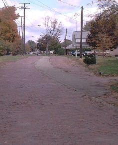
Two miles west of the bypass junction is the small town of Monroeville. Watch
for the wonderfully nostalgic Trail's End Motel not far from town—especially the
colorful sign. Highway improvements in and around Monroeville have rendered old
road remnants in two locations. Near the railroad underpass southeast of town,
short sections of Norwalk Street and Main Street
 survive as bits and pieces of
the original U.S. 20. West of town, County Road 238 is also a remnant of the
federal route.
survive as bits and pieces of
the original U.S. 20. West of town, County Road 238 is also a remnant of the
federal route.
(click)
This photogenic brick road remnant is now part of Norwalk Street in Monroeville.
On the boulder along the roadside, there is a plaque which commemorates the site
of nearby Camp Worcester, where volunteers from Ohio assembled, camped, and
drilled after answering President Lincoln’s call for service in 1861.
Similar highway improvements have also been made at Bellevue, which is seven
miles west of Monroeville. The original route of U.S. 20 followed Monroe Street
into downtown, crossing a pair of busy railroads that were properties of the New
York, Chicago and St. Louis Railroad, commonly known as the Nickel Plate Road.
Not coincidentally, the main line of the Nickel Plate Road had endpoints in
Buffalo and Chicago—major cities that would also become waypoints on the route
of U.S. 20. By 1935, the federal route was moved to its present location on an
easterly extension of Bellevue's Main Street.
Bellevue is still an important railroad town, although the previous railroads
are now properties of the Norfolk Southern Railway. Large shops and sprawling
yards are still active northeast of town. The Mad River and NKP Railroad
Museum—my favorite railroad museum in Ohio—is located close to downtown. Most
railfans could spend at least a couple hours here while exploring the large
static display of locomotives, cars, and hardware, not to mention the fine gift
shop.
Aside from sightseeing, Bellevue is also on the line between Huron County and
Sandusky County, which defines the western limits of the Connecticut Western
Reserve. This makes the location significant as the easternmost point of a state
road that was authorized by the Treaty of Brownstown in 1808. By this treaty,
the Indian tribes of northwest Ohio ceded a strip of land 46 miles long and 120
feet wide from what is now Perrysburg to the west line of the Connecticut
Reserve, together with land a mile wide on each side. Eventually, the square
mile sections that are typical in this part of Ohio were subdivided into long
thin parcels fronting on the state road, although the road was not sufficiently
improved until later.
Seven miles west of Bellevue is the village of Clyde. It is here that I first
noticed a new name on the county map, with the route of U.S. 20 also being shown
as the McPherson Highway. After a successful web search, I learned that General
James Birdseye McPherson was born here in 1828, when Clyde was called Hamers
Corners. General McPherson lost his life while in command of Union forces during
a Civil War battle in Atlanta, tragically becoming the youngest and highest
ranking Union officer to be killed in that war. Clyde is also recognized as the
hometown model for Sherwood Anderson's Winesburg, Ohio books.
Another seven miles beyond Clyde is Fremont, which is the seat of Sandusky
County. The present U.S. 20 bypass around Fremont was completed in about 1960,
and was the first four-lane bypass in Ohio along this federal route. The
antiquity of the bypass is sometimes seen in the narrow median and compact
interchanges that would no longer meet the design standards of today. The
original route follows State Street all the way through the historic town, which
was originally platted in 1816 as Croghanville. It is one of only four towns in
Ohio that were laid out by the federal government—Perrysburg (1816),
Gnadenhutten (1824), and Upper Sandusky (1843) are the others.
Croghanville was named from Major General George Croghan, who led the successful
defense of Fort Stephenson on the west bank of the Sandusky River. In 1813,
General Croghan and 160 men turned back a combined British and Indian force of
more than three thousand with one small six-pound cannon named "Old Betsy."
Croghan ordered his men to fire and then move the cannon around the fort as fast
as possible, giving the impression that the fort was better armed. After taking
the Fremont name, the city later became famous as the home of Rutherford B.
Hayes, 19th President of the United States. His lovely residence and final
resting place at Spiegel Grove—along with a fine library—are now a state
historic site.
Fremont was also previously known as Lower Sandusky, identifying its place on
the Sandusky River. Lower Sandusky was the eastern endpoint of the notorious
Maumee and Western Reserve Road—a thirty-one mile long "bridge" over the Great
Black Swamp that ended at the Maumee River in Perrysburg. The road thus covered
the western two-thirds of the state road that had first been authorized by the
Treaty of Brownstown in 1808. The Maumee and Western Reserve Road was authorized
by Congress in 1823 and completed in 1826. The historically poor conditions of
the road are best recalled in Ardath Dansford's Perrysburg Revisited:
For perhaps two months of the year, July and August, if they were dry enough, the road was passable. The remainder of the time it offered steady employment for inhabitants of the area in helping to pull stalled teams out of mudholes. Roadside taverns did a thriving business in providing accommodations for travelers. In 1834 to 1836, there were thirty-one such establishments, very nearly equaling the distance in miles from Perrysburg to Fremont. In response to the furor over what some called "the worst road on the continent," Ohio officials in 1838 appropriated $40,000 to surface the road with macadam. When finished in 1841 it was one of the first such paved highways, and further expenditure of approximately $125,000 by the state to construct ditches and culverts made the Fremont Pike a major access route east and west.
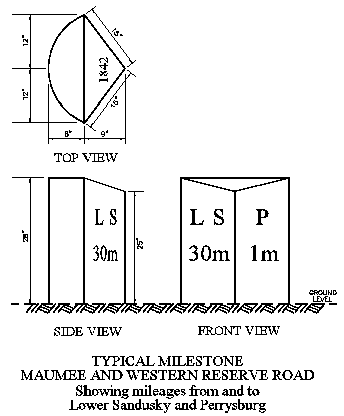
In 1842, one year after the first major improvements were
finished, thirty limestone mileposts were placed along the north side of the
road. The initial letters of Lower Sandusky and Perrysburg are shown on the west
and east face of each milestone, respectively, along with the mileage from and
to those pioneer towns. The first milestone is in front of a residence in
Fremont at 1206 W. State Street. On my last tour of the route on 2/20/2002 (note
the numerical coincidences), I counted twenty-six out of thirty milestones, most
of which were replicas of the originals.
Four miles west of Fremont, the Delorme Ohio Atlas and Gazetteer labels an
intersection as Fourmile House Corner. It is my guess that there may have been a
tollhouse here from the years when the Maumee and Western Reserve Road was also
a turnpike. Ironically, a contemporary toll road now parallels the historic
route—although in 2002, truckers were clogging U.S. 20 to avoid paying the
apparently steep fees required for using the Ohio Turnpike. Thus, I made it a
point not to stop along the side of the busy road any more than I had to.
Near milepost eleven and at the junction with State Route 51 is the intersection
known as Busy Corners. At this point, the original State Route 2, along with the
named auto routes—the Toledo-Cleveland-Buffalo Trail and the Yellowstone
Trail—diverged from the old state road and followed a popular path toward Toledo
that passed through Elmore. The official Ohio map of 1950 actually shows this as
a multiple lane route, which would seem quite redundant today. However, U.S. 20
never followed this option, and continued on the route of the old turnpike
toward Woodville and Perrysburg—which in many places is still two lanes today.
Both Woodville and Perrysburg are proud of their heritage on the Maumee and
Western Reserve Road. At
www.roadsideusa.info Russell Rein reports that the Woodville Historical
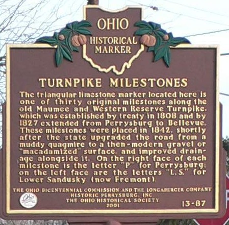
Society was active in placing milestone replicas along the highway. In 1966,
they also erected a sign next to the milestone (LS 15 P 16) in downtown
Woodville. At Perrysburg, there is a Milestone Park at the last marker along the
route, with a new and informative Ohio Historical Society marker placed
 nearby in 2001.
(click) Milestone LS 30 P 1 at Milestone Park in Perrysburg.
(see sign)
Perrysburg is a town steeped in history. Laid out in 1816, it is named for
Commodore Oliver Hazard Perry, whose naval triumph on Lake Erie led to American
victory in the west in the War of 1812. Perrysburg is at the foot of the rapids
of the Maumee River, just downstream from where Fort Meigs was built on the same
south bank by General William Henry Harrison during the winter of 1812 and 1813.
The fort withstood two sieges of the British and Indians in the spring and
summer of 1813. The Ohio Historical Society recently opened an impressive new
Museum and Education Center at the site.
The route of U.S. 20 enters Perrysburg on Fremont Pike and Sandusky Street, then
angles west onto Indiana Avenue. After two blocks, the route then turns north
toward the river for three blocks on Louisiana Avenue, which is one of my
favorite streets in the entire state. The government surveyors that laid out the
city showed great wisdom in platting the right-of-way of Louisiana Avenue at a
width of two chains (132 feet), which now allows for diagonal parking and wide
sidewalks so that patrons can better enjoy their frequent visits to the several
interesting shops and eateries along the way. A memorial statue honoring
Commodore Perry is at the north end of Louisiana Avenue, along the north side of
Front Street.
These three blocks of Louisiana Avenue would have also been the route of the
Dixie Highway, which followed Front Street into town
from Rossford. However, the Dixie Highway may not have joined the route of U.S.
25 until reaching a point in the south part of town. I find it fascinating that
three federal routes once radiated from the square grid of Perrysburg. Along
with U.S. 20 and U.S. 25, the route of U.S. 23 bore south-southeasterly along an
extension of Louisiana Avenue that is still known as the McCutcheonville Pike.
At the Perry Monument, the route of U.S. 20 turns west from Louisiana Avenue
onto Front Street and crosses the Maumee River into the city of Maumee. In
Maumee, the route is also known as Conant Street, and on the way through town,
two more federal highways are intersected—U.S. 24 and an alternate route of U.S.
20. The alternate route, first signed as U.S. 20-South from 1932 to 1934, put
three of the four biggest towns in Fulton County—Swanton, Delta, and Wauseon,
the county seat—on or near its path. It was renumbered as U.S. 20A on the
official Ohio map of 1935, and maintains that designation today.
North of Maumee, Conant Street bends to the north and becomes Reynolds Road.
After a few miles through the busy west side of Toledo, U.S. 20 finally resumes
westerly with a left turn onto Central Avenue and aims toward Indiana on the old
Toledo-Angola-Goshen Trail. Two miles beyond the Fulton County line, the route
quickly passes through the settlement now known as Assumption, which takes it
name from the local parish church. The maps and road guides from the 1920s show
the place name as Caraghar—the surname of the owner of the community's general
store.
Most of the route of U.S. 20 west of Toledo follows earlier roads which traced
section lines and half-section lines. This includes a twenty-two mile
straightaway from Lucas County to the western part of Fulton County. East of
Perrysburg, the route generally followed paths that owed their heritage to
geology and geography, with geometry strongly coming into play where the
shortest possible path across the Great Black Swamp was necessary. The only area
in the eastern part of the state where the road traces a rectangular survey grid
is between Oberlin and Norwalk.
During those years when there was a U.S. 20-South, this part of U.S. 20 was
marked as U.S. 20-North. Although the northern route was an original part of the
federal highway network, there was no southern alternate until 1932. The
important U.S. 20 designation was restored to the favored northern route when
U.S. 20-South was renumbered as U.S. 20-A on the 1935 map.
West of Toledo, communities and villages on the route of U.S. 20 are few and far
between. Like Assumption, the crossroads community of Oakshade is one of the
smallest dots on the map. The incorporated town of Fayette—which thus gets a
splash of yellow on the Ohio map—is located in the northwest corner of Fulton
County, and is supposedly named in honor of the Marquis de Lafayette. Four miles
west of Fayette, U.S. 20 enters Williams County, the tenth and final Ohio county
to be traversed by this version of the federal route.
In Williams County, Alvordton and Pioneer are the only incorporated villages on
the route. There is one significant section of old road remnants southwest of
Pioneer. Now disguised as Road Q and Road 13, an old right angle corner in the
route was
 long
ago replaced by a new curve and bridge crossing at the West Branch of the St.
Joseph River. Another quarter-circle arc that is twelve miles easterly from the
Indiana line returns the route of U.S. 20 to its final westerly bearing.
Ironically, U.S. 20 leaves Ohio within earshot of the Ohio Turnpike—the modern
toll road which opened in 1956, replacing the federal route as the main highway
across the top of the Buckeye State.
long
ago replaced by a new curve and bridge crossing at the West Branch of the St.
Joseph River. Another quarter-circle arc that is twelve miles easterly from the
Indiana line returns the route of U.S. 20 to its final westerly bearing.
Ironically, U.S. 20 leaves Ohio within earshot of the Ohio Turnpike—the modern
toll road which opened in 1956, replacing the federal route as the main highway
across the top of the Buckeye State.
(click) A mechanical drawing of the typical milestone placed between Lower Sandusky and Perrysburg on the north side of the Maumee and Western Reserve Road, an early state road in Ohio that became the route of U.S. 20.
|
A BRIEF HISTORY OF THE MILE The complete article was originally
published in Issue #28 of Buckeye Ramblings, the official newsletter of the
Ohio Lincoln Highway League. |