UNOFFICIAL LIST OF THE NAMED AUTOMOBILE TRAILS OF OHIO
Under Construction
Michael G.
Buettner
January 2006
|
PART ONE—ALPHABETICAL LIST
|
|
| 1. 2-C Highway 2. 3-C Highway 3. ATLANTIC-PACIFIC HIGHWAY 4. Belt Line (1 of 2) 5. Belt Line (2 of 2) 6. Benjamin Franklin Highway 7. Blue and Gray Trail 8. Blue Grass Way 9. Canton-Alliance-Pittsburgh Trail 10. Capitol Trail 11. Chicago-Buffalo Highway 12. Cincinnati-Parkersburg Way 13. DIXIE HIGHWAY 14. French Lick Route 15. HARDING HIGHWAY 16. Harrison Trail 17. Hoosier Highway 18. Hoosier Dixie Highway 19. Hub Highway 20. Huntington-Manitou-Culver Trail |
21. Industrial Way 22. Lakes to Ocean Highway 23. LINCOLN HIGHWAY 24. Marion-Kenton Trail 25. Muncie-Lima-Fremont Trail 26. NATIONAL OLD TRAILS ROAD 27. Ohio-Indiana-Michigan Way 28. PIKES PEAK OCEAN-TO-OCEAN HIGHWAY 29. Rose Trail 30. Scioto Trail 31. Sherman-Sheridan Trail 32. Shore Road 33. Tecumseh Trail 34. Terre Haute-Columbus-Cincinnati Trail 35. Toledo-Angola-Goshen Trail 36. Toledo-Chicago Pike 37. Toledo-Cleveland-Buffalo Trail 38. VICTORY HIGHWAY 39. Wayne Highway 40. YELLOWSTONE TRAIL |
NAMED AUTOMOBILE TRAILS IN OHIO
PART TWO—BRIEF DESCRIPTIONS
1. 2-C Highway
This trail may have been either an inspiration for or a response to the more famous 3-C Highway (see #2 below).
The 2-C Highway was a parallel route, meandering from Columbus to Cleveland by
way of Delaware, Mt. Gilead, Mansfield, Ashland, and Medina. Beyond Delaware,
the route would have followed the original version of U.S. Route 42.
2. 3-C Highway
Perhaps the best remembered auto trail contained entirely within the state’s
borders, this highway connected Ohio’s three largest cities—Cleveland, Columbus,
and Cincinnati. Several years ago, OHIO Magazine did a nice story which highlighted
potential points of interest for travelers on this cross-state highway. Other
cities on the route were Wilmington, Washington C.H., Mt. Vernon, Wooster, and
Medina. When the first state routes were numbered on the official Ohio highways
map of 1923, the 3-C Highway was wisely designated as State Route 3. Unlike most
of the original low-numbered state routes—low numbers being 1 through 10, with a
standard sign assembly that included both a name sign and a number sign—State
Route 3 survives today along much of its original path. Oddly, the state route
never became a differently numbered federal highway like many of the others in
that elite group of ten.
3. ATLANTIC-PACIFIC HIGHWAY
This auto trail seems to be a late entry to the list of transcontinental routes.
Dave
Schul’s auto trails web site has its termini at New York City and Los
Angeles, with intermediate cities including Philadelphia, Baltimore, and
Washington, D.C. Hal Meeks, in his On the Road to Yellowstone book, has
an eastern terminus at Norfolk, Virginia, on a route too far south to touch the
aforementioned three cities. It either case, it parallels the Midland Trail west
of the Appalachians, and parallels the National Old Trails Road beyond the
Mississippi River. On my 1926 auto trails map of Ohio, this highway enters the
state at Ironton, then follows the north side of the Ohio river to and through
Cincinnati. Before reaching Los Angeles, the route passed through St. Louis,
Wichita, and Phoenix. In 1923, the Ohio segment of this highway would have been
part of the original route of State Route 7, also known as the Ohio River
Road—easily the longest numbered route in the state. That portion of this route
which was followed by the Atlantic-Pacific Highway would later be renumbered as
U.S. Route 52.
4. Belt Line (1 of 2)
This is one of two routes in Ohio that have this name. On my 1922 auto trails
map, the route enters the state southwest of Celina (west of Coldwater), then
makes its way to and through Columbus, terminating at Logan. The route also
passed through Wapakoneta, Bellefontaine, and Marysville. East of Celina, this
bears a strong resemblance to a combination of State Route 29 and U.S. Route 33
on the maps of today. Of course, the Belt Line would have been a two-lane route
on the predecessors of the relocated four-lane highways of today.
5. Belt Line (2 of 2)
This is the second of the two routes in Ohio that have this name. On my 1922
auto trails map, this version is in the eastern part of the state—leaving
easterly from Warren on its way into Pennsylvania.
6. Benjamin Franklin Highway
This highway does not show up on any map in my limited collection. This listing
is based on information from Dave Schul’s auto trails web site. According to
Dave, the route had termini in Philadelphia and Akron. No intermediate cities
are listed. The terminal points of this
highway are the same as today’s Interstate Route 76. I have no graphics for
the sign of this highway.
7. Blue and Gray Trail
This is another trail for which I have no map confirmation. Again according to
Dave Schul, this trail had termini in Columbus, Ohio and Charleston, West
Virginia. Based on that description, the route would likely resemble forerunners
of U.S. Route 23 and U.S. Route 35. However, no intermediate cities are listed.
I have no graphics for the sign of this highway.
8. Blue Grass Way
Based on my 1922 auto trails map, this highway went from Cincinnati to Norwalk,
Ohio by way of Lebanon, Xenia, Springfield, Marysville, Marion, Bucyrus, and
Willard. Thus, it appears to be a combination of U.S. 42 to Xenia, U.S. 68 to
Springfield, and State Route 4 most of the rest of the way.
9.
Canton-Alliance-Pittsburgh Trail
This route will be easily recognized by Lincoln Highway fans as the notorious
1924 Detour Route, which is often called for in guide books of that
era—including A Complete Official Guide of the Lincoln Highway.
Louisville, Salem, Columbiana, and East Palestine were waypoints on this popular
diversion from the transcontinental route. This trail is more completely covered
by an article elsewhere on this web site. On an obscure map in the 1925
Clason Touring Atlas, this route, at least in Ohio, is labeled as the Governor
Cox Highway.
10. Capitol Trail
There appears to have been more than one trail with this name in the United
States, but in Ohio, this named trail was between Toledo and Columbus. Cities
along the route were Fostoria, Upper Sandusky, Marion, and Delaware. Thus, the
route was an early version of today’s U.S. Route 23.
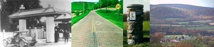
11. Chicago-Buffalo Highway
This route may have been a later combination of numbers 36 and 37 below.
However, at Dave Schul’s auto trails web site, the western terminus of the route
is given at Kendallville, Indiana. Why it doesn’t go all the way to Chicago is a
mystery to
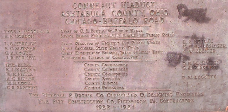 me. Perhaps the cartographer did not draw all the pertinent symbols.
Buffalo is given as the eastern terminus.
me. Perhaps the cartographer did not draw all the pertinent symbols.
Buffalo is given as the eastern terminus.
Probably one of the last references to the Chicago-Buffalo
Road still being used. This may also be one of the earliest references to
long time Bureau of Public Roads chief Thomas
McDonald (1919 to 1953). Please click for a very large photo.
12. Cincinnati-Parkersburg Way
For some reason, this appears on my both my 1921 and 1922 auto trails map only
as a route between Cincinnati and Chillicothe, Ohio, with no extension to
Parkersburg, West Virginia. Assuming the extension, this course could be
followed today by a combination of State Route 28 and U.S. Route 50. However,
Dave Schul’s auto trails web site indicates another version of route, on the
north side of the Ohio River. Given that was the original route of State Route
7, it may have been the better road in the named trails era, but with all the
bends in the river, the route would have been half again as much longer.
An article on the history of this road in Ohio appears elsewhere on this
web site.
13. DIXIE HIGHWAY
The first north-south transcontinental automobile route across Ohio, the Dixie
Highway was actually a network of highways that all funneled to Miami Beach,
Florida. Both the highway and the city in the sun were conceived by Carl G.
Fisher, whose other big ideas included the Lincoln Highway and the Indianapolis
Motor Speedway. In 1923, the route of the Dixie Highway became State Route 6 in
Ohio, earning it both a name sign and number sign in the post assembly. This
designation lasted only three years, with the posting of the U.S. 25 federal
shield. That federal route no longer exists in Ohio, and only a short section of
a State Route 25 near Toledo conjures memories of that once significant
cross-country number. Interstate Route 75 has become the modern equivalent of
Ohio’s branch of the Dixie Highway.
14. French Lick Route
Before basketball icon Larry Bird made this small Indiana community famous as
his home town, French Lick had been a popular destination as a health resort
along the tracks of the Monon Railroad. The named auto trail route which came
later crossed from Indiana into Ohio and terminated in Cincinnati. I have no
location for the route in Indiana. I do have a map showing the sign for this
route, but it is too small for me to reproduce with confidence (it looks like a
guy walking with a bagpipe; I don’t think that’s what it really is).
15.
HARDING HIGHWAY
I almost hesitate to call this route a transcontinental route. However, I have a
copy of a brochure—published by the Chamber of Commerce in Burlington, Iowa [!],
and including a Rand McNally map dated 1931—which implies that the Harding
Highway crossed the country from Washington, D.C. to California. There may have
been two branches of the highway in California, with endpoints at San Francisco
(this one for sure) and Los Angeles (this one a maybe). The brochure focuses on
that part of the route between Pittsburgh and Denver, extolling the virtues of
“a scenic all-weather highway” that was also “a shorter route east and west.” A related story on
this web site covers that portion of the old highway in Ohio between
Galion and Lima, via Marion and Kenton. The
colorful story of U.S. 30-North (Lincoln
Highway) and U.S. 30-South (Harding Highway) is also told in A
History and Road Guide of the Lincoln Highway in Ohio, which can be read
elsewhere at this web site. Galion, Marion (U.S. President Warren G. Harding’s
home town), and Lima (OLHL President Mike Buettner’s home town) are the only
known locations where the Harding name is still attached to this route—Harding
Way in Galion; Harding Highway in Marion and Marion County; and Harding Highway
again in Lima and Allen County.
16. Harrison Trail
I have this trail on a 1922 auto trails map as being between Portsmouth and Port
Clinton, making it one of the longest auto trails entirely within the borders of
Ohio. Other cities on the route were Chillicothe, Circleville, Columbus,
Delaware, Marion, Upper Sandusky, Tiffin, and Fremont. Thus, the trail was later
followed by early versions of U.S. 23 and State Route 53. However, this trail
may have been superseded, at least in part, by the Scioto Trail (see #30 below).
17. Hoosier Highway
This is a significant regional highway that clips the northwest corner of Ohio.
Bryan is the only Ohio county seat on the route, which had termini in
Evansville, Indiana and Detroit, Michigan. In Ohio, parts of today’s State Route
2 and U.S. Route 127 resemble the zigzags of this meandering highway.
18. Hoosier Dixie Highway
This is another regional trail that barely makes it onto the Ohio map. Not
surprisingly, most of the trail is in Indiana, with a northern terminus at
Goshen. It entered Ohio near Harrison and had a southern terminus at Cincinnati,
probably following an early version of U.S. Route 52. It is unclear whether this
trail was considered an element of the Dixie Highway system, but one way or
another, it was likely conceived as a feeder route that would meet the Ohio
branch of the Dixie Highway at Cincinnati. Warsaw, Marion, Anderson, and New
Castle were Indiana cities on the route.
19. Hub Highway
This is one of the shortest trails I have found on my 1922 auto trails map of
Ohio. Its endpoints were at Dayton and Chillicothe, with Xenia and Washington
C.H. as intermediate cities.
20. Huntington-Manitou-Culver Trail
Of all the trails in this list of forty, this may be the ultimate example of the
auto trail excess that led to government intervention and road numbering.
Huntington is a county seat in Indiana, Manitou is a lake near the town of
Rochester, and Culver is a small village most noted for a nearby military
academy. For whatever reason, this unlikely route was extended into Ohio,
terminating in Lima (of all places, the home town of this writer). In the 1920s,
the roads west of Lima on which this trail was marked were so nondescript that
they were never part of any state highway numbering system.
However, the boosters of the trail did manage to come up with a pretty
interesting sign.
21. Industrial Way
Not surprisingly, this was a trail through the heart of the Steel Valley,
connecting Cleveland and Pittsburgh with a convoluted course through Ravenna,
Warren, and Youngstown. In fact, the course was so convoluted that I am not even
going to attempt to retrace it with the numbered routes of today!
22. Lakes to Ocean Highway
Dave Schul’s web site has this highway in his list of national auto trails. It
does not appear on any map in my limited collection. Endpoints are given as
Cleveland and Tampa. There are no intermediate cities listed. I have no
graphics for the sign of this highway.
23. LINCOLN
HIGHWAY
For a comprehensive story about the Lincoln Highway in Ohio, read A History
and Road Guide of the Lincoln Highway in Ohio, which is the featured article
on this web site.
24. Marion-Kenton Trail
This short trail would have been the earliest original part of the
Harding
Highway (see #15 above). Its western terminus was at Lima; its
eastern terminus appears to be north of Mt. Gilead at an intersection with the
2-C Highway. Namesake cities Marion and Kenton were the only other county seats
on the route, which actually became part of the original U.S. 30 in 1926 before
the federal government compromised by renumbering it as U.S. 30-South in 1931.
25. Muncie-Lima-Fremont Trail
This is the only auto trail having my home town of Lima as part of the name.
This is an interesting mix of stair steps and diagonals between Muncie, Indiana
and Fremont, Ohio that essentially displaced passenger traffic on the old Lake
Erie and Western Railroad, which was unfavorably derided as the “Leave Early and
Walk.” Other county seats on the route were Portland (Indiana), Celina, Lima,
and Findlay. This is another route whose boosters came up with an interesting
symbol sign without the tried and true tricolor stripes.
26. NATIONAL OLD TRAILS ROAD
An article on the history of this road in Ohio appears elsewhere on this
web site.
27. Ohio-Indiana-Michigan Way
This is another route that reached Cincinnati after meandering through
Indiana—crossing the border near Hamilton. In Indiana, the route passed
through Richmond, Winchester, Portland, Decatur, Fort Wayne, Kendallville, and
Lagrange before entering Michigan. This compares well to the route of U.S. 27 of
today.
28. PIKES PEAK
OCEAN-TO-OCEAN HIGHWAY
A brief article on the history of this road in Ohio appears elsewhere on this
web site.
29. Rose Trail
This is a nicely linear trail that connects a string of five county seats in
Ohio—Springfield, Urbana, Bellefontaine, Kenton, and Findlay. The endpoint
cities of Springfield (National Old Trails Road) and Findlay (Dixie Highway)
were also waypoints on two of the most important transcontinental routes. This
same route is followed today by U.S. Route 68.
30. Scioto Trail
This trail appears to be a late addition to the auto trails map of Ohio. It does
not appear on either my 1922 map or my 1926 map, but it is listed on Dave
Schul’s auto trails web site. However, Dave has the route going only from
Portsmouth to Chillicothe. By comparison, the Scioto Trail is mentioned both by
name and by numbers (U.S. Route 23 and State Route 4) in a 1927 book published
in part by the Ohio Department of Highways. It is mentioned as one of three
principal north-south traffic routes in the state—the others being the Dixie
Highway (U.S. Route 25) and the Cleveland-Marietta Road (originally parts of
U.S. Route 21 and State Route 8). The Cleveland-Marietta Road—apparently a
name acquired by continuous use—does not seem to be an auto trail in the same
sense as those in this list. Based on the ODH description, the endpoint
cities of the Scioto Trail were Portsmouth and Sandusky. Intermediate county
seats were Waverly, Chillicothe, Circleville, Columbus, Delaware, Marion, and
Bucyrus. The Harrison Trail (see #16 above) had followed this same path as far
north as Marion before diverging to Port Clinton. For some odd reason, the
arrow-straight course of State Route 4 beyond Marion had never been previously
marked as a named trail—despite its ancient and colorful history as the Columbus
and Sandusky Turnpike, an early state road dating back to 1827.
31. Sherman-Sheridan Trail
Bearing the names of two Civil War generals from Ohio, this short trail
connected Zanesville and Circleville. Lancaster (where Sherman was born) and
Somerset (where Sheridan made his home) were the important waypoints on this
route, which today is closely followed by U.S. Route 22.
32. Shore Road
This trail along Lake Erie may have predated the Yellowstone Trail, which was
marked on much of this same path in 1919. The terminal cities for the Shore Road
were Fremont and Cleveland, with Sandusky as an intermediate point. Oddly, two
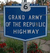 different roads between Fremont and Sandusky are labeled as the Shore Road on my
1922 auto trails map, perhaps in an effort to gain some independence from the
Yellowstone Trail. Today this route can generally be traced by following the
original paths of U.S. 6—which after the end of the auto trails era, gained a
memorial name of its own as the Grand Army of the Republic Highway.
different roads between Fremont and Sandusky are labeled as the Shore Road on my
1922 auto trails map, perhaps in an effort to gain some independence from the
Yellowstone Trail. Today this route can generally be traced by following the
original paths of U.S. 6—which after the end of the auto trails era, gained a
memorial name of its own as the Grand Army of the Republic Highway.
Andover, Ohio
33. Tecumseh Trail
This short trail was named for the great chief of the Shawnee Indians who was
such a major historical figure in this region. Its endpoints were at Jackson,
Michigan and Toledo. In Michigan, much of this route would now be followed by
U.S. Route 223. In the Toledo area, the route would now be generally followed by
the diagonal courses of Monroe Street and State Route 51.
34. Terre Haute-Columbus-Cincinnati Trail
This is another trail which leaves Cincinnati along the north side of the Ohio
River on its way to Indiana. Before terminating at Terre Haute, this route
probably passed through the Indiana cities of Greensburg, Columbus, and
Bloomington. If so, this likely was a better auto trail than many others,
because Indiana’s State Route 46 follows much of that same path today.
35. Toledo-Angola-Goshen Trail
This short trail likely served as a short-cut between two earlier
transcontinental routes, with endpoints at Toledo (Yellowstone Trail) and
Goshen, Indiana (Lincoln Highway). It would also have also offered a shorter
option than the Toledo-Chicago Pike (see below). Most of the
Toledo-Angola-Goshen Trail became the original route of U.S. Route 20, so there
was some wisdom in the development of this trail location. Even today, U.S. 20
is a fine road through small villages in northwestern Ohio, and a passive
toll-free alternative to the Ohio Turnpike.
36. Toledo-Chicago Pike
A route that may have predated the Toledo-Angola-Goshen Trail on better roads at
the time of its inception, the Toledo-Chicago Pike passed through Wauseon and
Bryan before entering Indiana. This route became the original route of Ohio
State Route 2, and was virtually overlapped by the Yellowstone Trail between
Toledo and Bryan. I have no information on the course of this route across
Indiana, but it likely resembles the route of U.S. 6.
37. Toledo-Cleveland-Buffalo Trail
This route seems to be the eastern complement of the two trails immediately
above. However, at some point, it appears that this trail was combined with the
Toledo-Chicago Pike (see above) to form the Buffalo-Chicago Trail (see #11 in
this list).
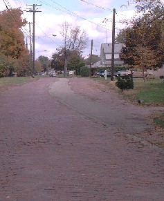 Between Toledo and Cleveland, the subject trail passed through
Fremont, Norwalk, and Elyria, on a course which became the original route of
U.S. 20. East of Cleveland, the route was essentially overlapped by the
Yellowstone Trail, and was also generally followed by the original route of U.S.
20.
Between Toledo and Cleveland, the subject trail passed through
Fremont, Norwalk, and Elyria, on a course which became the original route of
U.S. 20. East of Cleveland, the route was essentially overlapped by the
Yellowstone Trail, and was also generally followed by the original route of U.S.
20.
Old US 20 near Geneva, Ohio.
38. VICTORY HIGHWAY
According to Frank X. Brusca (www.route40.net),
“the Victory Highway was established following World War I as a memorial to
those who fought and died in that conflict.” For some reason, Brusca does not
have the route as a transcontinental route—giving Kansas City and San Francisco
as endpoints. This may have been based on the limits of a great Mohawk-Hobbs
Guide that he has reproduced for the site. However, other evidence indicates
that the route had its eastern terminus at New York City. This conflicting
evidence may be explained by the fact that the eastern half of the Victory
Highway almost perfectly overlapped the National Old Trails Road (see #26 in
this list), which had the senior identity and a route guide of its own. Thus, a
similar guide for the eastern half of the Victory Highway would have been
redundant. The Victory Highway had a more independent alignment in the
West—especially in Utah and Nevada—where its struggles to establish a route are
reminiscent of those of the Lincoln Highway. Today, the route of the Victory
Highway can be traced by following the original courses of U.S. 40—not only in
Ohio, but generally for the length of its path. Please see the referenced web
site for a graphic of the Victory Highway sign.
39. Wayne Highway
General “Mad Anthony” Wayne led the American victory in the Battle of Fallen
Timbers (1794), which led to the signing of the Greenville Treaty (1795). By
this treaty, the Indians ceded the land that makes up most of Ohio, plus parts
of Indiana, Michigan, and Illinois. This auto trail passed through much of the
same area as General Wayne’s armies, and a string of forts erected under his
leadership is recalled by names on the maps of today (Fort Recovery and Fort
Jefferson are examples). Many historical markers in this corridor bear the
symbol of the Anthony Wayne Parkway, but based on their divergent locations, the
parkway doesn’t seem to follow one particular route like the Wayne Highway. The
Wayne Highway had endpoints in Cincinnati and Jackson, Michigan, and passed
through seven county seats in Ohio—Hamilton, Eaton, Greenville, Celina, Van
Wert, Paulding, and Bryan. The original trail would have been marked as State
Route 9 in 1923 (and thus it would also have had a name sign in the post
assembly), but after some early extensions to the federal system, it became U.S.
Route 127.
40. YELLOWSTONE TRAIL
A brief article on the history of this road in Ohio appears elsewhere on this
web site.
NAMED AUTOMOBILE TRAILS IN OHIO
PART THREE—MAP REFERENCES
In compiling the list above, I have generally studied four auto
trails maps in my limited collection, all of which were published at the peak of
auto trails activities in the 1920s:
1. A partial map of Ohio dated 1921 and published by Rand McNally. It appears
that this map is one part of a set, being
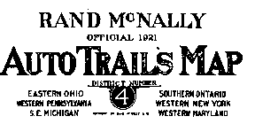 labeled as “District 4” and including
only parts of several states—such as the east two-thirds of Ohio and the west
one-third of Pennsylvania. As I recall, my blueprint copy of the original map
came to me through the courtesy of OLHL founder Esther Oyster. This hard-to-read
map (because of scale) shows 21 auto trails in Ohio.
labeled as “District 4” and including
only parts of several states—such as the east two-thirds of Ohio and the west
one-third of Pennsylvania. As I recall, my blueprint copy of the original map
came to me through the courtesy of OLHL founder Esther Oyster. This hard-to-read
map (because of scale) shows 21 auto trails in Ohio.
2. A 1924 Rand McNally map which I found in the collections of the Ohio
Historical Society in Columbus, Ohio. This is the key map in my collection,
because it shows 31 auto trails in Ohio—more than any other map. I have this map
in the form of two microfilm images,
 which I can take to the local library for
viewing and partial printing.
which I can take to the local library for
viewing and partial printing.
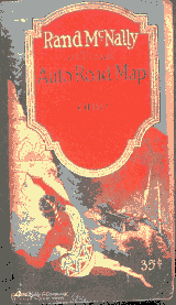
3. A 1926 Rand McNally auto trails map of Ohio which came to me through the
courtesy of Abe Yalom. Abe kindly let me borrow his original long enough to make
11”x17” excerpt copies of this map, plus the wonderful color cover. Only 14 auto
trails appear on this map, but several appear for the first time here.
4. A 1927 Automobile Blue Book map which shows five named trails in Ohio which
were also transcontinental routes. The map is drawn at a larger scale than the
Rand McNally map, making it a very useful tool for tracing the alignments of
both the trails and the early numbered highways. This map also came to me from
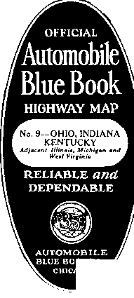 Esther Oyster, in the form of 11”x17” excerpt copies.
The only other major reference that I have specific to the auto
trails in Ohio is Dave Schul’s
web site.
I should also mention that during my several years of research which focused on
the subject of the Lincoln Highway, I also received copies of interesting maps
or road guide excerpts from renowned highway historians and collectors such as
Brian Butko, Dave Cole, Russell Rein, and Mike Weigler. Similarly, the late Hal
Meeks is to be remembered for providing me much of the information that I have
about the Yellowstone Trail, plus other named trails in Indiana.
Given the limited collection on which this named auto trails
work is based, it is very likely that the descriptions for the above routes may
have other variations in other years. It is also very likely that there is some
obscure or short-lived trail that is not in this list of forty. Thus, if you
have an auto trails map for Ohio (or Indiana, in some cases) which shows a named
route with either a variation not described here, or some route not listed here,
please consider making a hard copy reproduction of same so that this work can
become more comprehensive. Please send copied materials to this writer at:
Mike Buettner
c/o Kohli & Kaliher Associates, Inc.
2244 Baton Rouge Avenue
Lima, Ohio 45805
Your contribution will be greatly appreciated and appropriately credited. Please
know that no additions or revisions will be made to this text without a map or
guide reference. It is my experience that no modern text contains information as
reliable as the lines and symbols of the original maps and road guides.