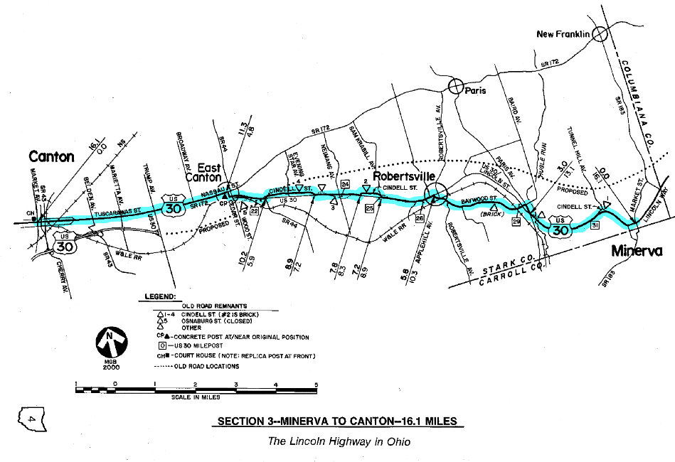
SECTION 3—MINERVA TO CANTON—16.1 MILES
 By studying old roadway plans, LHA members confirmed that this culvert alongside U.S. 30 west of Minerva was part of the Lincoln Highway alignment before 1935.
The route of the 1928 Lincoln Highway between Minerva and Canton includes some of the best old highway remnants in the entire state of Ohio. Within this section are the four Cindell Street segments, plus the splendid brick portions of Baywood Street. Other interesting remnants, such as an old bridge abutment at Hugle Run, have also been recovered. These bypassed alignments became remnants starting in the late 1930s, when U.S. Route 30 was essentially rebuilt between Minerva and East Canton. 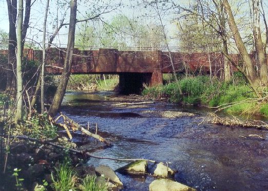
This one-of-a-kind brick bridge is over Hugle Run between Minerva and Robertsville. [Webmaster note: This bridge was replaced in April 2002.]
The four Cindell Street remnants are spread over nine miles of the present route between Minerva and East Canton. Three of these four remnants closely parallel U.S. Route 30—which is marked by Stark County as Lincoln Street—and have two endpoints that intersect at or near the main road. A fourth remnant branches from the main road and dead-ends at an old stream crossing. An extension of this fourth remnant, now reclaimed by weeds, can be accessed from the main road by turning south at Neimans Avenue. The original road crossed Neimans Avenue where the line of utility poles is now located.
One of the Cindell Street remnants is a very good half-mile section of brick, and has been charted as a worthwhile detour from U.S. Route 30. This remnant is immediately north of and parallel with U.S.30 near the Sam Krabill Avenue intersection, between mileposts 24 and 25 on the federal route. Reference should be made to both the strip maps and odometer charts to anticipate the appropriate turns 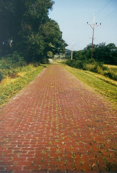 from U.S.Route 30. An interesting report claims that bricks missing from the east end of this remnant are now in the fireplace of one of the nearby homes.
Cindell Street is one of two significant stretches of brick roadway in Stark County. A section of Baywood Street is another.
Another departure from U.S. 30 which is part of the charted course is also the longest of the four Cindell Street remnants. This remnant, 1.3 miles in length, is one to two miles east of East Canton (or nine to ten miles west of Minerva), but has only blacktop pavement at the surface—however, some very small areas of brick can be observed at the east end of this remnant. Much of this remnant is followed by a line of tall utility poles, which tend to follow the north right-of-way line of the road. Eastbound tourists especially can use these poles as an indicator of where to turn from U.S. Route 30, opposite the junction of State Route 44.
The best of all the remnants in this section, and perhaps the best remnant in Ohio, is the part of the original highway now designated as Baywood Street. This photogenic roadway, like two of the Cindell Street remnants, is part of the charted course, and is a definite "must-see." It is 2.4 miles in length, and features the longest stretches of brick paving of any that can still be found on the various Lincoln Highway routes in Ohio. Baywood Street bears westerly from U.S. 30/Lincoln Street near the Paris Avenue intersection, then meanders to a point nearly one mile away from the main road before returning into the southeast side of Robertsville. It could be described as the "high road" to Robertsville, because it reaches an elevation of 1290 feet—the highest point in Stark County on the early Lincoln Highway route. Today's U.S. Route 30 takes a somewhat lower and more level path, and features a significant "cut" just east of Robertsville.
Historically, the eastern part of this section, between Minerva and East Canton, was probably one of the most challenging in Ohio for Lincoln Highway officials to plot on the early maps. Whereas most of the sections in the state were mapped with the routes of Ohio's Inter-County Highway System, there was no such designation to follow here in 1913. Eventually, a designation was given—probably as a result of the Lincoln Highway—which was I.C.H. #493, or Osnaburg-Minerva Road. Osnaburg, which is listed in the Lincoln Highway Road Guides through 1921, was the original name of East Canton, but the name was changed in the late 1910s because of anti-German sentiments resulting from World War I.
It is important to note that Osnaburg-Minerva Road was not part of Main Market Route No. 3, which took a northerly route out of Minerva, turning westerly at the town of New Franklin, then passing through the community of Paris. This variation avoided the large jog in the market route, and appears to be the only part of the Lincoln Highway route in eastern Ohio which did not follow the route of Main Market Route No. 3. In 1918, the citizens of Paris Township questioned this variation, promoting the market route which by then was also known as Governor Cox Market Route Number Three. Much like a similar campaign by the citizens of Marion and Kenton, it was a spirited but unsuccessful effort.
Curiously, there is an "unofficial map" of the Lincoln Highway, dated 1915, which shows the route passing through New Franklin and Paris. This would seem to support the claim of the citizens of Paris Township that the Lincoln Highway had indeed followed the market route at some point in time. However, despite this evidence, the Lincoln Highway Association was firm in denying their claim.
In contrast, the western part of this section, between East Canton and Canton, had been part of a route that was on the first Inter-County Highway maps. This particular segment was part of I.C.H. #72, or Canton-New Franklin Road, a roadway which would compare well with today's State Route 172 and also with yesterday's market route.
While in East Canton, watch for one of the concrete posts placed by the Boy Scouts in 1928. This marker can be found on the south side of Nassau Street—as this part of the Lincoln Highway route is named in East Canton—one-half block west of Cedar Street. This is the first of three concrete posts in Ohio which are at or near their original positions along the route.
The roadway between East Canton and Canton has certainly seen much improvement since those earliest Lincoln Highway days. Thankfully, although much of the route is now multiple lanes, some old highway architecture has survived, including several old-fashioned tourist courts. Within Canton, the city has created a "run-around" in the downtown area by marking State Route 172 on "one way" parallel streets, away from Tuscarawas Street. Tourists should stay with Tuscarawas Street all the way through Canton to follow the route of the Lincoln Highway.
Two major attractions in Canton are the McKinley National Memorial and the Professional Football Hall of Fame, both within a few minutes of Tuscarawas Street. William McKinley—born in nearby Niles, and the 25th president of the United States—was entombed at this impressive monument after his tragic assassination in 1901. In 1904, the scarlet carnation was adopted as Ohio's state flower in memory of McKinley, who often wore his favorite flower on his lapel. 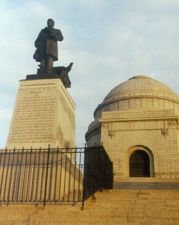
William McKinley—born in nearby Niles, Ohio, and the 25th president of the United States—was entombed at this impressive monument after his assassination in 1901. In 1904, the scarlet carnation was adopted as Ohio's state flower in memory of McKinley, who wore that flower on his lapel.
The monument is part of the McKinley Museum of History, Science and Industry, with the museum building featuring discoveries for kids of all ages, plus a planetarium and research library. The patio area of the monument offers an excellent view of the city, and the park area provides a wonderful spot for a family picnic. At the east side of the north end of the driveway area, a memorial stone was placed in 1949 by the Lincoln Highway Memorial Association. Research has turned up no clues as to the activities and history of this group. According to the inscription on the headstone, the paving on the overlook and the curbing in the motor court are dedicated "to all our soldiers of all wars."
During the first weekend of August, the eyes of the football world are turned toward Canton, which was the birthplace of professional football, and is now home to its hall of fame. The highlight of the weekend is the annual induction of new members to the hall, with parades and the first Monday Night Football game of the National Football League exhibition season rounding out the festivities.
Another point of interest in Canton is the Classic Car Museum, which is six blocks south of the Stark County Court House, on Market Avenue South. The museum has more than 35 antique cars in the showroom of an old Ford-Lincoln dealership. According to the AAA guide, "the automobiles are displayed in an atmosphere of period memorabilia, including fashions, advertisements, a jukebox and a photograph collection of automobile pioneers." Bob Lichty, director of the museum, is also Ohio's State Director for the Lincoln Highway Association.
For those westbound tourists who would prefer to bypass downtown Canton, plus the slow and congested stretch between Canton and Massillon, stay on U.S. 30 where it turns at Trump Avenue. From this point, follow Trump Avenue/U.S. 30 to the interchange with the four-lane bypass around Canton and Massillon. This U.S. 30 bypass will rejoin the 1928 route of the Lincoln Highway at the State Route 172 intersection just east of Dalton. Other options include taking the U.S. Route 30 bypass west to Interstate Route 77, which can be taken northerly into the west part of Canton, or taking the U.S. Route 30 bypass west to State Route 21, which can be taken northerly into downtown Massillon.
Odometer charts for this section
Strip Maps for this section