SECTION 11a—LIMA TO DELPHOS—16.6 MILES
(Second Route via Gomer—18.1 Miles)
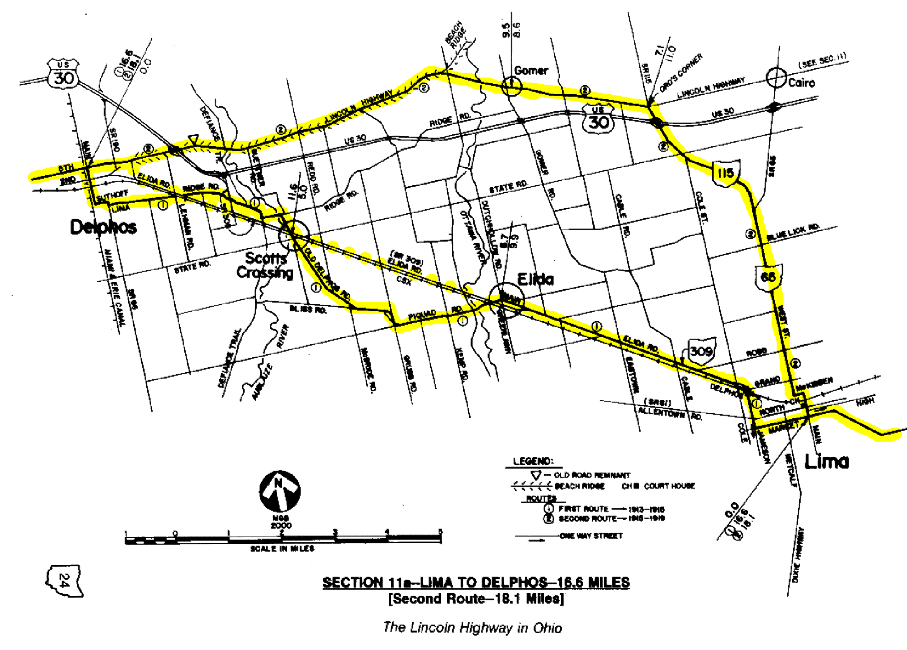
Before 1915, the Lincoln Highway followed a somewhat forgotten route between Lima and Delphos, passing through Elida and Scott's Crossing. This was the original route of Inter-County Highway #127, or Lima-Delphos-Western Road, and yet another part of Main Market Route No. 3. From Lima to Elida, this route is now generally followed by State Route 309, but west of Elida the route is now made up of almost a dozen county roads and city streets.
Bearing west on Market Street from the old Public Square in downtown Lima, the original route turned north on Jameson Avenue, leaving the city by way of Elida Road after crossing the Pennsylvania Railroad tracks at the Delphos Avenue crossing. Today, the Jameson Avenue route can not be perfectly followed for two reasons—first, the street is one way southbound for several blocks south of the North Street intersection; and second, a railroad overpass was built in the mid-1970s which bypassed both the intersection and grade crossing at Delphos Avenue.
Farther west, the route passed through Elida on that town's Main Street, and again crossed the Pennsylvania Railroad west of town. West from Elida, the original route followed roadways now known as Piquad, Grubb, Bliss, McBride, and Old Delphos Roads, again crossing the Pennsylvania tracks at the community of Scott's Crossing. Most highway maps show this location as Auglaize, which was apparently a name used by either the railroad or interurban or both. The first version of U.S. 30 would later follow this same winding path, but in the early 1930s improvements were made in the original Bliss Road corridor which would eliminate four turns.
Beyond Scott's Crossing, the original route continued to Delphos on roads which now include Defiance Trail and Ridge Road. The farm where the author's father and grandfather grew up is on the opposite side of the Auglaize River in this area, and many Buettner forefathers are laid to rest at the Walnut Grove Cemetery along Ridge Road. A dangerous fourth crossing of the Pennsylvania tracks was made one mile west of the cemetery at Pohlman's Crossing on an extension of Ridge Road, but that crossing is now made at Lehman Road. A metal farm building now straddles a short piece of the old alignment east of the Lehman Road/Ridge Road intersection.
It appears that the original skewed crossing at the railroad was eliminated when a new version of U.S. 30-S was built in the mid-1930s between Elida and Delphos. This new alignment was constructed on the right-of-way of an old interurban route between Lima and Fort Wayne, and is the present location of State Route 309 west of Elida, running parallel with the old Pennsylvania tracks. This idea of building a highway on the roadbed of an abandoned interurban has been used in several places in northwest Ohio.
The first Lincoln Highway route entered the southeast side of Delphos on Lima Avenue, which terminates at what is now Spencerville Road and State Route 66. This is also the location of Waterworks Park, which was a free tourist camp in those earliest days of auto travel. The route made its way to Main Street in Delphos by following Spencerville Road north for one block to Suthoff Street, where it turned west for another three blocks to Main Street. Because this is also the route of State Route 66, it is easy to follow this first route into downtown, where for the fifth time in fifteen miles, there is a crossing of the old Pennsylvania Railroad. With two more crossings yet to come in Van Wert County, the 1913 route of the Lincoln Highway actually crossed this same railroad eleven times between Bucyrus and the Indiana line. In 1915, a new Lincoln Highway route was created between Lima and Delphos which would survive until 1919. It appears that this change may have coincided with the opening of both the Lima State Hospital north of the city, and a splendid new stretch of brick paving leading to it. At the same time, major construction was begun on the original Lincoln Highway route, including a new bridge over the Auglaize River north of Scott's Crossing. Thus, it appears that this would have been an appropriate time to move the route, adding only 1.5 miles to the distance, but significantly reducing the number of turns and railroad crossings.
This new route would have left Lima by way of Main Street, McKibben Street and West Street, following what is now State Route 65 out the north side of town. Beyond the State Hospital, the route angled northwesterly with what is now State Route 115, turning west toward Delphos at Ord's Corner. West of this corner, the route would be the same as the traditional Lincoln Highway route established in this section in the summer of 1919 at the coming of the army convoy [see §11].
It is interesting to follow the Lima newspaper accounts as the army convoy approached the area. As late as July 8—the day after the convoy departed Washington, D.C.—one newspaper was reporting that there would be an overnight stop in Lima, with visits to the the local truck plant. However, with the straight route through Beaverdam being the new route of the Lincoln Highway, Lima was instead passed by, and on the night of July 16, Delphos had the honor of hosting the "immense army truck train."
After the passing of the convoy, Lima did try unsuccessfully to get back on the Lincoln Highway route. However, through correspondence with Austin F. Bement, vice-president of the Lincoln Highway Association, they quickly learned that there was "no chance" of persuading the association to change the route back through the city. Lima's recognition, perhaps belatedly, of the importance of the transcontinental route can still be noted as late as 1924. In the fifth and final edition of the Official Road Guide, there is a twelve-page insert in the Ohio section sponsored by the Lima Board of Commerce and/or the Lima Automobile Club, advertising and promoting the local hotels, service stations, and such. Thus, there are more advertisements for businesses in Lima in that Guide than for any other city on or off the Lincoln Highway.
Odometer charts for these sections
Extract or delete HTML tags based on their name or whether or not they contain some attributes or content with the HTML editor pro online program.