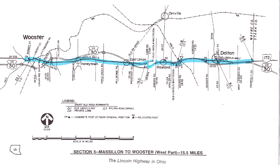
SECTION 5—MASSILLON TO WOOSTER—22.1 MILES
The route of the 1928 Lincoln Highway between Massillon and Wooster includes the first part of the route in Ohio to be bypassed by a multiple-lane highway. Surprising as it may seem, this bypass was at the town of Dalton (pronounced DAL-ton, like the "DAL" sound in Dallas), which at the time of construction in the early 1950s, had a population of just under 1000. One would probably have expected that the first such U.S. 30 bypass would have been around Canton or Mansfield, the two largest cities on the route at that time. Of course, bypasses do now exist at both those places, but the distinction of being the first Lincoln Highway town in Ohio to be bypassed with a superhighway belongs to Dalton.
Today's original route through Dalton is now marked Main Street inside the village, and Old Lincoln Way outside the village. In fact, almost all of the old locations in Wayne County are now marked Old Lincoln Way, plus either County Road 30A or Township Road 30A. The route of U.S. 30 east of Wooster is currently marked as East Lincoln Way.
Interestingly, the relocated route of U.S. 30 west of Wooster [see §6] is marked West Lincoln Way. Because this particular section of roadway was not opened until the mid-1960s, the use of the Lincoln Way name here would be consistent with the state's contention that wherever U.S. Route 30 happens to be at a given time is also the route of the Lincoln Highway. That claim is based on an administrative action of the Director of Highways which is dated August 1, 1930. This action granted approval of a resolution adopted by the commissioners of ten of the eleven Lincoln Highway counties in Ohio, which proposed to designate portions of U.S. Route 30 and all of State Route 5 as the Lincoln Highway. Therefore, based on their nomenclature for the new and old roads, Wayne County appears to be the only county in Ohio that is interpreting the language of the approved resolution "to the letter."
In Dalton, two of the concrete posts set by the Boy Scouts can still be found close to the roadway. Although not in their original locations, these two markers are both in good condition, and can be watched for by referring to the odometer charts. Both posts are on private property, but the post in the middle of town is at the back of the sidewalk, and can be observed more easily. The other post is back farther on a residential lot, and should be viewed without leaving the main road. Another relocated post is not far from here at the northeast corner of the intersection in Riceland.
Dalton is also one of eight Ohio towns where the notion of "Main Street Across America" is faithfully perpetuated. In fact, the Drake Hokanson book that bears that title includes a nice picture of Dalton's tree- lined Main Street in one of its photo sections. If you have the book with you during your travels, try to determine where the picture was taken [the photograph is opposite page 17 of the Hokanson book].
Several other remnants of the early route in this section carry the Old Lincoln Way designation. A little more than two miles west of Dalton, there is a grade separation with a railroad. There are short dead-end segments both northeast and southwest of the present bridge. The segment northeast of the structure gives access to properties there, and is paved and signed. The segment immediately southwest of the structure is unmarked and is now a lane on private property. This lane can be best observed by making a small diversion from the charted course, turning south on Kidron Road (Wayne County Road 52).
This same diversion also provides an access to a driveable "through" remnant of Old Lincoln Way which is opposite the lane area, bearing westerly from Kidron Road for one-half mile to Kohler Road (Sugar Creek Township Road 129). Another concrete post can be observed along this roadway, and is the second of three posts in Ohio which are at or near their original positions. At its west end, this Old Lincoln Way remnant intersects Kohler Road immediately south of an intersection with four-lane U.S. Route 30.
Because of the dangers of leaving and rejoining a busy part of U.S. 30, this particular Lincoln Highway remnant has not been made a part of the charted course. If possible, the tourist is encouraged to make this diversion while traveling eastbound, so that right turns can be made when leaving and rejoining U.S. Route 30. The westbound tourist would have to make two difficult and dangerous left turns—twice crossing the eastbound lanes—which is not recommended. This part of U.S. 30 may be the busiest part of that route in the state, and includes a high percentage of truck traffic.
Another Lincoln Highway remnant, about one mile long, is in the vicinity of the U.S. 30 intersections with Kansas Road (East Union Township Road 189) and Carr Road (Wayne County Road 84), or about four to five miles west of Dalton. This remnant is on the north side of U.S. 30, and runs parallel with the four-lane route. The white-on-green road name signs erected at the west end of this remnant designate this road as East Union Township Road 30A. Like the diversion between Kidron Road and Kohler Road, this segment can be driven end-to-end from points at or near U.S. 30, and again because of dangerous turning movements, is not part of the charted course. In this case, the tourist is advised to make this particular diversion only while traveling westbound.
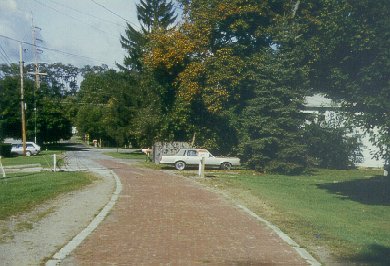 Perhaps the oldest exposed remnant of Lincoln Highway brick is in Wooster, where Sylvan Road dead-ends at the west bank of Apple Creek. To reach this location, turn south from Pittsburgh Avenue onto BauerRoad for 0.1 mile.
The final significant remnant that exists in this section is at the east edge of Wooster. This particular remnant dates back to the early 1920s, and is perhaps the oldest remnant of the Lincoln Highway in the state. It is now marked as part of Sylvan Road, which branches from the south side of Pittsburgh Avenue, and dead-ends at the west bank of Apple Creek. The east end of the roadway is a slightly curving ten-foot wide section of brick pavement with nine-inch wide cement borders, and is a definite "must-see" on any tour of the Lincoln Highway in Ohio. Refer to both the strip maps and the odometer charts for the locations of the best turning movements from the main road. Unfortunately, the construction of the bypasses and interchanges on the opposite side of Apple Creek has destroyed other parts of the original location of Sylvan Road.
 In Wooster, the route of the Lincoln Highway follows Pittsburgh Avenue and Liberty Street into one of the most attractive downtown areas in Ohio. In 1996, this was one of five downtown communities in the United States which received the Great American Main Street Award for downtown improvements and historic preservation. Also of interest is Boyd's Drug Store at the southeast corner of the town square, a turn-of-the-century pharmacy with an old-fashioned interior that has never been modernized.
Constructed in 1878, the Wayne County Court House is in Wooster, in what is arguably the most attractive downtown on Ohio's Lincoln Highway. In 1996, the city received the Great American Main Street Award for downtown improvements and historic preservation.
North of downtown, the College of Wooster is home to one of seven statues of Abraham Lincoln that were "crafted by the William Mullins Co. of Salem, Ohio, for display in towns along the Lincoln Highway." Given to the college in 1915, the statue had stood at three locations on campus, but after years of exposure to the elements—both natural and criminal—was in need of restoration. After resting in the care of local blacksmith Stewart Simonds, the statue was returned to the campus for display in 1997.
East of downtown Wooster, and on the south side of Pittsburgh Avenue, is Lincoln Way Elementary School. The earlier school at this site was named Pittsburgh Avenue School, but after it was combined with the Walnut Street School, the "new" school took its present historic name. Colorful murals in the gymnasium highlight the highway on maps of both Ohio and the Wooster area.

Located on what is now Pittsburgh Avenue, the Lincoln Way Elementary School recalls the name of the historic route through Wooster. Colorful murals in the gymnasium highlight the highway on maps of Ohio and the area.
Historically, this section of the Lincoln Highway was a part of Main Market Route No. 3, and was designated Inter-County Highway #69, or Massillon-Wooster Road. It also carried the typical designation of State Route 5 before inheriting the federal designation of U.S. Route 30.